 Arctic SDI catalogue
Geochemical stream sediment dataset, West and South Greenland
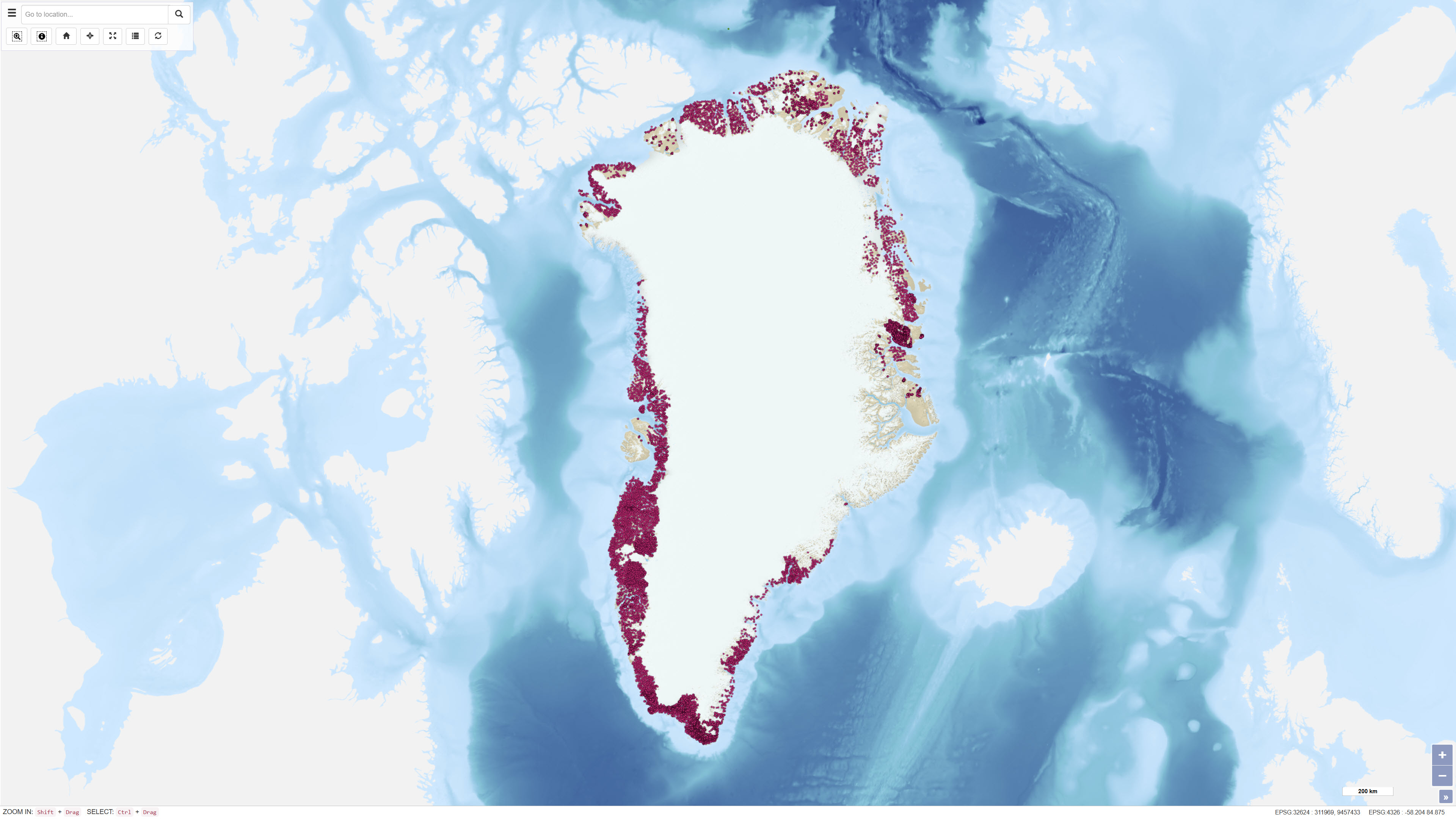
This dataset comprises regional geochemical stream sediment data from West and South Greenland and forms the basis of the Geochemical Atlas of West and South Greenland (Steenfelt, 2001).
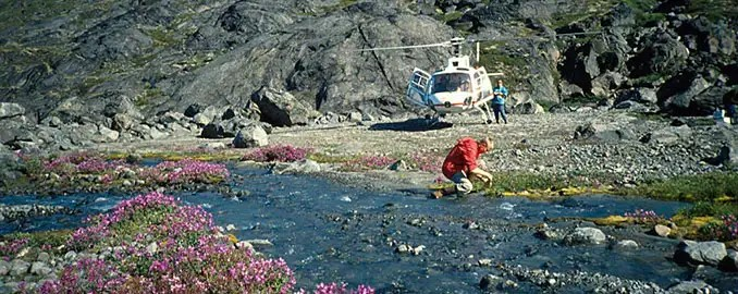
The Geochemical Atlas of West and South Greenland presents the results of a regional stream sediment geochemical mapping programme conducted between 1979 and 1998. A total of 7,122 stream sediment samples were collected from low-order streams with near-uniform spatial coverage across West and South Greenland.
The <0.1 mm grain-size fraction of 500 g samples was analysed for major and trace elements using X-ray fluorescence spectrometry (XRF), instrumental neutron activation analysis (INAA), delayed neutron counting (DNC) and loss on ignition (LOI). After systematic calibration and quality control to eliminate analytical bias between different methods and time periods, a harmonised and internally consistent dataset was established containing up to 43 elements per sample.
The atlas provides a regional overview of the geochemical composition of the minerogenic fraction of stream sediments and constitutes a geochemical baseline dataset for geological mapping and mineral exploration in Greenland.
Simple
- Date ( Publication )
- 2023-11-13
- Identifier
- dk.geus / grl_geochemical_atlas_west_south_greenland
- Presentation form
- Digital map
- Purpose
- To provide a regional geochemical baseline dataset for West and South Greenland to support geological mapping and mineral exploration.
- Status
- Completed
- Maintenance and update frequency
- As needed
- Keywords ( Theme )
-
- Dataset
- Geochemistry
- Stream sediments
- West Greenland
- South Greenland
- Trace elements
- Database
- Forskningsemner Forskningsemner ( Theme )
- Geografisk Geografisk ( Place )
- Access constraints
- Other restrictions
- Use constraints
- Other restrictions
- Other constraints
- CC BY 4.0
- Other constraints
- The dataset represents a regional geochemical baseline and should not be used for detailed local assessments without supplementary investigations.
- Spatial representation type
- Vector
- Denominator
- 1000000
- Metadata language
- en
- Character set
- UTF8
- Topic category
-
- Geoscientific information
- Begin date
- 1979-01-01
- End date
- 1998-12-31
))
- Supplemental Information
- Values below the detection limit are coded as 0 in the dataset. Major element oxides are reported as volatile-free compositions, while loss on ignition (LOI) and other volatile components are listed separately. The dataset represents a harmonised and calibrated compilation of results obtained by different analytical techniques and over different analytical periods. Detailed methodological descriptions and quality assessments are provided in GEUS Report 2001/46.
- Reference system identifier
- WGS 84 / UTM 24N (EPSG:32624)
- Distribution format
-
-
WMS
(
)
-
WFS
(
)
-
GeoJSON
(
)
-
XLSX
(
)
-
SHP
(
)
-
WMS
(
)
- OnLine resource
-
Download
(
WWW:DOWNLOAD-1.0-http--download
)
Download dataset from GEUS' Dataverse
- OnLine resource
-
Interactive webmap
(
WWW:LINK-1.0-http--link
)
Interactive map displaying the dataset.
- OnLine resource
-
Geochemical atlas of Greenland - West and South Greenland
(
DOI
)
Steenfelt, A. (2001). Geochemical atlas of Greenland - West and South Greenland. [2 versions: Printed maps included or 1 CD-Rom included]. GEUS. Danmarks og Grønlands Geologiske Undersøgelse Rapport Vol. 2001 No. 46 https://doi.org/10.22008/gpub/17839
- OnLine resource
-
Compilation of data sets for a geochemical atlas of West and South Greenland based on stream sediment surveys 1977 to 1997
(
DOI
)
Steenfelt, A. (1999). Compilation of data sets for a geochemical atlas of West and South Greenland based on stream sediment surveys 1977 to 1997. GEUS. Danmarks og Grønlands Geologiske Undersøgelse Rapport Vol. 1999 No. 41 https://doi.org/10.22008/gpub/16138
- OnLine resource
-
Calibration of stream sediment data from West and South Greenland A supplement to GEUS Report 1999/41
(
DOI
)
Steenfelt, A. (2001). Calibration of stream sediment data from West and South Greenland A supplement to GEUS Report 1999/41. GEUS. Danmarks og Grønlands Geologiske Undersøgelse Rapport Vol. 2001 No. 47 https://doi.org/10.22008/gpub/17840
- OnLine resource
-
geochemistry_greenland_ss_sw
(
OGC:WMS-1.3.0-http-get-capabilities
)
WMS for Geochemical Atlas of Stream sediment samples from South and West Greenland
- OnLine resource
-
geochemistry_greenland_ss_sw
(
OGC:WFS-1.0.0-http-get-capabilities
)
WFS for Geochemical Atlas of Stream sediment samples from South and West Greenland
- OnLine resource
-
Download
(
WWW:DOWNLOAD-1.0-http--download
)
Download dataset as shapefile
- OnLine resource
-
Download
(
WWW:DOWNLOAD-1.0-http--download
)
Download dataset as GeoJSON
- Hierarchy level
- Dataset
- Statement
-
Stream sediment samples were collected between 1979 and 1998 as part of a regional geochemical mapping programme conducted by the Geological Survey of Greenland (now GEUS). Sampling focused on low-order streams to achieve representative coverage of drainage catchments.
Prior to 1993, sample positions were recorded on 1:100,000 topographic maps and subsequently digitised. After approximately 1993, GPS was used for positioning. Around 2000, positional data were adjusted to a revised topographic reference system.
Laboratory analyses were carried out using multiple analytical techniques. Calibration procedures were applied to remove systematic differences between analytical methods and time periods. After quality control, a consistent dataset comprising 7,122 samples and up to 43 analysed elements was established.
- File identifier
- 019cf744-b02c-4c12-91cc-3ffd5f9c2925 XML
- Metadata language
- Danskda
- Character set
- UTF8
- Hierarchy level
- Dataset
- Date stamp
- 2026-03-02T12:23:59.912879Z
- Metadata standard name
- ISO 19115:2003/19139
- Metadata standard version
- 1.0
Overviews
Spatial extent
Provided by
