 Arctic SDI catalogue
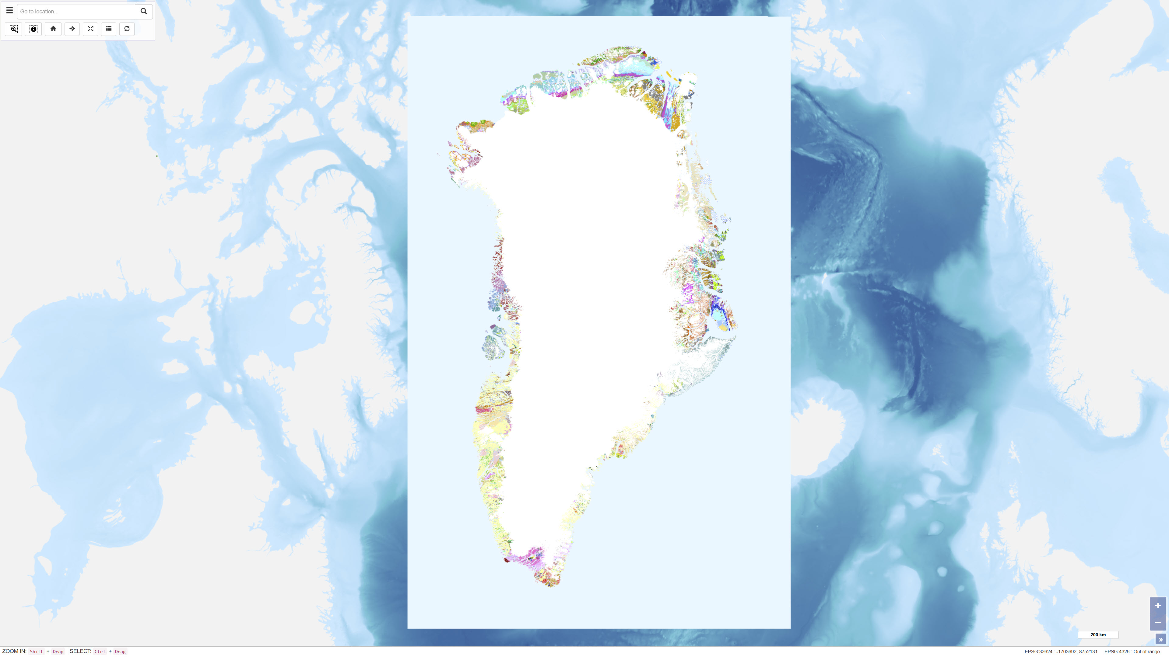
Geological Map of Greenland, 1:500.000
The geological map of Greenland at a scale of 1:500 000 is based on 14 digitised map sheets covering the whole of Greenland, with amendments in specific areas (Pedersen et al. 2013, GEUS Bulletin, DOI: 10.34194/geusb.v28.4727). The original digital version of the map was released through the Greenland Portal in 2012. Continued advances in geological knowledge have necessitated successive revisions in order to keep the map up to date.
During the most recent update, a number of geographical areas were revised based on new geological data and interpretations, including parts of West Greenland, North Greenland, North-East Greenland, East Greenland and South-East Greenland. The updated map incorporates revised stratigraphic interpretations and improved representation of geological units and structures.
The map has undergone extensive quality control, including complete harmonisation of lineaments and structural elements across map-sheet boundaries. The geological legend is dynamic and reflects the content of the current map view. Geological units are supported by descriptive information, and for most map polygons links are provided to a geological unit database containing further descriptions.
Simple
- Date ( Publication )
- 2023-03-09
- Identifier
- dk.geus / grl_geolmap_greenland_500k
- Presentation form
- Digital map
- Purpose
- The purpose of the dataset is to provide an updated regional geological map of Greenland at a scale of 1:500.000 that synthesises existing and new geological knowledge into a consistent map representation. The dataset is intended for use in geological research, education, regional planning and assessment of mineral and other geoscientific resources.
- Status
- Completed
- Maintenance and update frequency
- As needed
- Keywords ( Theme )
-
- Dataset
- Geology
- Greenland
- Stratigraphy
- Structural geology
- ArcGIS
- QGIS
- Forskningsemner Forskningsemner ( Theme )
- Geografisk Geografisk ( Place )
- Access constraints
- Other restrictions
- Use constraints
- Other restrictions
- Other constraints
- CC BY 4.0
- Other constraints
- Use of the dataset requires acknowledgement of the Geological Survey of Denmark and Greenland (GEUS) as the data source.
- Spatial representation type
- Vector
- Denominator
- 500000
- Metadata language
- en
- Character set
- UTF8
- Topic category
-
- Geoscientific information
- Imagery base maps earth cover
- Begin date
- 2012-01-01
- End date
- 2023-03-09
))
- Supplemental Information
- The dataset is a regional geological map product at a scale of 1:500.000 and should be used with consideration of the map scale and level of generalisation. The map forms part of GEUS’ ongoing geological mapping of Greenland and contributes to the national geological map series.
- Reference system identifier
- WGS 84 / UTM 24N (EPSG:32624)
- Distribution format
-
-
WMS
(
)
-
WMTS
(
)
-
REST
(
)
-
WMS
(
)
- OnLine resource
-
Download
(
WWW:DOWNLOAD-1.0-http--download
)
Download dataset from GEUS' Dataverse
- OnLine resource
-
Interactive webmap
(
WWW:LINK-1.0-http--link
)
Interactive map displaying the dataset.
- OnLine resource
-
A new seamless digital 1:500 000 scale geological map of Greenland
(
DOI
)
Pedersen, M., Weng, W. L., Keulen, N. & Kokfelt, T. F. (2013): A new seamless digital 1:500 000 scale geological map of Greenland. GEUS Bulletin, 28, 65–68, DOI: 10.34194/geusb.v28.4727. This article describes the seamless digital 1:500 000 geological map of Greenland, based on 14 digitized map sheets with a harmonised legend and notes that the first version of the seamless map was completed in 2012. The article is published under a Creative Commons CC BY 4.0 license.
- OnLine resource
-
Geological_map_500k
(
ESRI:REST
)
ArcGIS REST Service
- OnLine resource
-
g500_geology_polygon_KLIKINFO
(
OGC:WMS-1.3.0-http-get-capabilities
)
ArcGIS WMS Service
- OnLine resource
-
Greenland_Geological_map_500k
(
OGC:WMTS-1.0.0-http-get-capabilities
)
ArcGIS WMTS Service
- Hierarchy level
- Dataset
- Statement
-
The geological map of Greenland at a scale of 1:500,000 (G500) was produced by vectorising scanned versions of previously published geological maps. Geological information from the maps was integrated with topographic data derived primarily from aerial photographs and other sources, supplemented locally by topography from printed maps.
During the vectorisation process, the scanned geological maps were adjusted to fit a new digital topographic framework. As the original paper maps generally had better local than absolute positional accuracy, this adjustment introduced local geometric differences between the digitised geology and the printed maps. Geological boundaries, structural elements and geological units were digitised and attributed with type and source information, and individual map sheets were combined into a seamless database.
Geometric inconsistencies across map-sheet boundaries were corrected during the compilation process. The geometric quality of the final map varies geographically, with mean positional errors of approximately 50 metres in areas with well-defined topography, and larger uncertainties in areas where topography was derived from paper maps. Harmonisation of geological nomenclature and legend content was undertaken to produce a consistent regional geological map for all of Greenland, taking into account differences in detail and presentation among the original source maps.
- File identifier
- 0343a36d-34d4-4305-89dc-4aea8461095d XML
- Metadata language
- Danskda
- Character set
- UTF8
- Hierarchy level
- Dataset
- Date stamp
- 2026-02-11T10:40:19.401803Z
- Metadata standard name
- ISO 19115:2003/19139
- Metadata standard version
- 1.0
Overviews
Spatial extent
Provided by
