 Arctic SDI catalogue
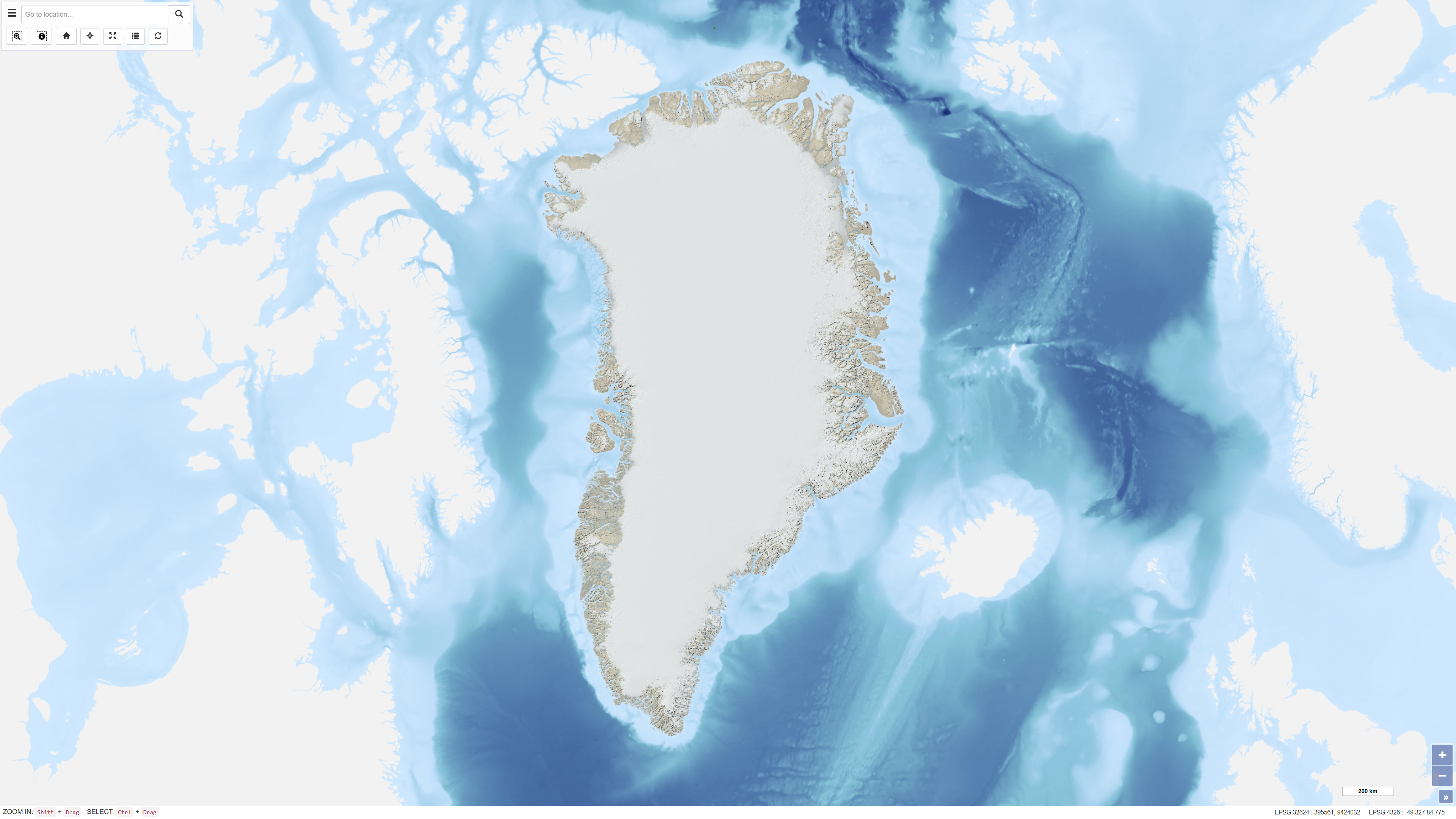
Multidirectional hillshade derived from the GIMP Digital Elevation Model, Greenland
This dataset comprises a multidirectional hillshade raster derived from the Greenland Mapping Project (GIMP) Digital Elevation Model. The hillshade was produced to serve as a semi-transparent overlay for cartographic applications, enhancing terrain depth and surface detail while preserving the original colour characteristics of underlying map layers.
The multidirectional illumination method reveals terrain variation from multiple light directions, providing improved representation of landforms compared to traditional single-direction hillshading. The dataset is intended for visualisation purposes in web maps and other cartographic products.
Simple
- Date ( Publication )
- 2023-03-24
- Identifier
- dk.geus / grl_multidirectional_hillshade_gimp
- Presentation form
- Digital map
- Purpose
- To provide an enhanced cartographic terrain visualisation based on the GIMP DEM for use as a semi-transparent overlay in mapping applications.
- Status
- Completed
- Maintenance and update frequency
- As needed
- Keywords ( Theme )
-
- Dataset
- Hillshade
- Digital elevation model
- Greenland
- GIMP
- Forskningsemner Forskningsemner ( Theme )
- Geografisk Geografisk ( Place )
- Access constraints
- Other restrictions
- Use constraints
- Other restrictions
- Other constraints
- This dataset is derived from the MEaSUREs Greenland Ice Mapping Project (GIMP) Digital Elevation Model (NSIDC-0715). As a condition of use, the original data source must be cited according to NSIDC’s recommended data citation.
- Spatial representation type
- Grid
- Denominator
- 500000
- Metadata language
- Da
- Character set
- UTF8
- Topic category
-
- Elevation
- Imagery base maps earth cover
- Begin date
- 2003-02-01
- End date
- 2009-10-31
))
- Supplemental Information
-
This dataset is derived from the GIMP Digital Elevation Model. Users must cite the original source according to Howat et al. (2014).
Howat, I.M., Negrete, A., & Smith, B.E. (2014): The Greenland Ice Mapping Project (GIMP) land classification and surface elevation datasets. The Cryosphere, 8, 1509–1518. https://doi.org/10.5194/tc-8-1509-2014.
- Reference system identifier
- WGS 84 / UTM 24N (EPSG:32624)
- Distribution format
-
-
WMS
(
)
-
WMTS
(
)
-
REST
(
)
-
WMS
(
)
- OnLine resource
-
Interactive webmap
(
WWW:LINK-1.0-http--link
)
Interactive map displaying the dataset.
- OnLine resource
-
Greenland_hillshade_UTM24N
(
ESRI:REST
)
ArcGIS REST Service
- OnLine resource
-
Hillshade
(
OGC:WMS-1.3.0-http-get-capabilities
)
ArcGIS WMS Service
- OnLine resource
-
Greenland_Greenland_hillshade_UTM24N
(
OGC:WMTS-1.0.0-http-get-capabilities
)
ArcGIS WMTS Service
- OnLine resource
-
MEaSUREs Greenland Ice Mapping Project (GIMP) Digital Elevation Model, Version 1
(
WWW:LINK-1.0-http--link
)
This data set consists of an enhanced resolution digital elevation model (DEM) for the Greenland Ice Sheet. It was constructed by combining ASTER and SPOT 5 DEMs over the ice sheet periphery and margin with AVHRR photoclinometry for the interior and far north, and calibrating the data to approximate mean ICESat/GLAS elevations from 2003 to 2009.
- Hierarchy level
- Dataset
- Statement
-
The multidirectional hillshade was derived from the Greenland Mapping Project (GIMP) Digital Elevation Model (Howat et al., 2014). The GIMP DEM provides surface elevation data for Greenland and forms the topographic basis for this visualisation product.
The hillshade was generated using a multidirectional illumination technique inspired by the cartographic principles of Eduard Imhof. Adjusted scaling suitable for large map extents was applied to enhance terrain variation across multiple scales. A colour ramp with intermediate transparency levels was combined with image processing techniques to preserve both terrain detail and underlying map colours, producing a semi-transparent cartographic overlay.
- File identifier
- 038f976c-f8d1-4102-9bb4-dc8b775e4bae XML
- Metadata language
- Danskda
- Character set
- UTF8
- Hierarchy level
- Dataset
- Date stamp
- 2026-02-24T07:49:42.679317Z
- Metadata standard name
- ISO 19115:2003/19139
- Metadata standard version
- 1.0
Overviews
Spatial extent
Provided by
