 Arctic SDI catalogue
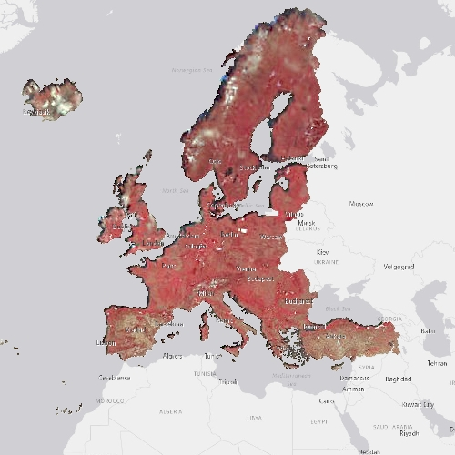
Pan-European High Resolution Image Mosaic 2012 - False Colour, Coverage 1 (20 m), July 2015
The pan-European High Resolution (HR) Image Mosaic 2012 provides HR2 (High Resolution: 20 meter) coverage over Europe.
The surface covered by the image dataset is 5.8 million square kilometres and has a spatial resolution of 20 meters. The imagery is composed during specific acquisition windows between 2011 and 2013. Images are derived from the following satellite sensors:
Resourcesat-1/-2
SPOT-4/-5
The mosaic primarily is used as input data in the production of various Copernicus Land Monitoring Service (CLMS) datasets and services, such as land cover maps and high resolution layers on land cover characteristic and can be also useful for CLMS users for visualizations and classifications on land.
The input imagery for the creation of the mosaic is provided by ESA. Due to license restrictions, HR Image Mosaic 2012 is only available as a web service (WMS), and not for data download.
Simple
- Date ( Creation )
- 2015-07-02T00:00:00
- Date ( Publication )
- 2015-07-02T00:00:00
- Edition
- 01.00
- Identifier
- copernicus_r_3035_20_m_hrim-fc-cov1-2012_i_2011-2013_v01_r00
- Maintenance and update frequency
- As needed
- GEMET - INSPIRE themes, version 1.0 ( Theme )
- Keywords
-
- Keywords
-
- GEMET ( Theme )
- Continents, countries, sea regions of the world. ( Place )
-
- United Kingdom
- EEA38 (from 2020)
- Spatial scope ( Theme )
- Temporal resolution ( Temporal )
-
- As needed
- EEA topics ( Theme )
- Access constraints
- Other restrictions
- Other constraints
- no limitations to public access
- Use constraints
- Other restrictions
- Other constraints
-
The Copernicus component is governed by Regulation (EU) No 2021/696 of the European Parliament and of the Council of 28 April 2021 establishing the Union Space Programme and the European Union Agency for the Space Programme and repealing Regulations (EU) No 912/2010, (EU) No 1285/2013 and (EU) No 377/2014 and Decision No 541/2014/EU. Within the Copernicus component, a portfolio of land monitoring activities has been delegated by the European Union to the European Environment Agency (EEA) and the DG Joint Research Centre of the European Commission.
The Copernicus land monitoring products and services are made available on a principle of full, open and free access, as established by the Commission Delegated Regulation (EU) No 1159/2013 of 12 July 2013.
Free, full and open access to the products and services of the Copernicus Land Monitoring Service is made on the conditions that:
1. When distributing or communicating Copernicus Land Monitoring Service products and services (data, software scripts, web services, user and methodological documentation and similar) to the public, users shall inform the public of the source of these products and services.
2. Where the Copernicus Land Monitoring Service products and services have been adapted or modified by the user, the user shall clearly state this.
3. Users shall make sure not to convey the impression to the public that the user's activities are officially endorsed by the European Union.
- Spatial representation type
- grid Grid
- Distance
- 20 m
- Metadata language
- en
- Topic category
-
- Environment
- Imagery base maps earth cover
))
- Begin date
- 2011-01-01
- End date
- 2013-12-31
- Unique resource identifier
- EPSG:3035
- Distribution format
-
-
GeoTIFF
(
)
-
GeoTIFF
(
)
- OnLine resource
- Product Information & Technical Documentation ( WWW:LINK )
- OnLine resource
- https://copernicus.discomap.eea.europa.eu/arcgis/services/GioLand/2012_Coverage1_20m/MapServer/WMSServer?request=GetCapabilities&service=WMS ( OGC:WMS )
- OnLine resource
- https://copernicus.discomap.eea.europa.eu/arcgis/rest/services/GioLand/2012_Coverage1_20m/MapServer ( ESRI:REST )
- Hierarchy level
- Dataset
Conformance result
- Date ( Publication )
- 2010-12-08
- Explanation
- See the referenced specification
- Statement
-
Original narrow and extended acquisition windows have been progressively reviewed in 2012 and in 2013, in order to meet user requirements:
• Cloud coverage: ≤ 5% per country.
• 20m RMSE/ Geolocation accuracy after orthorectification.
In addition, products should mostly be:
• Without haze
• Snow coverage < 10%: [only for glaciers/perennial snow]
• Instrument incidence/Pointing angle < 30%.
Note: SPOT products are:
• Not atmospherically corrected
• 1% saturated pixels.
- File identifier
- 08b8793b-2815-4902-9163-d353baeb7c96 XML
- Metadata language
- en
- Character set
- UTF8
- Hierarchy level
- Dataset
- Date stamp
- 2025-10-09T10:35:27.660544Z
- Metadata standard name
- ISO 19115/19139
- Metadata standard version
- 1.0
Overviews
Spatial extent
Provided by
