 Arctic SDI catalogue
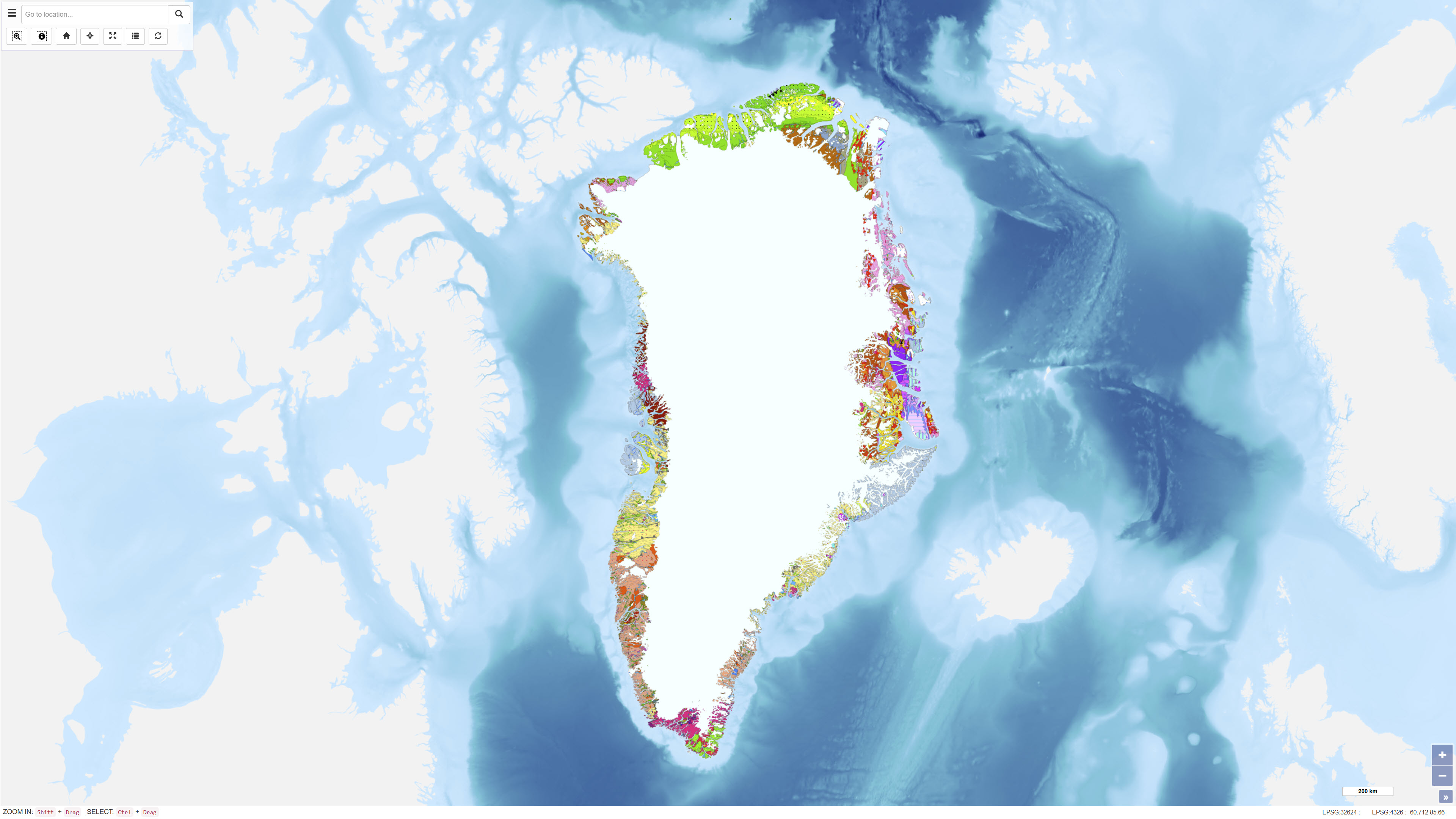
Geological map of Greenland, 1:2.500.000
The Geological Map of Greenland at scale 1:2.500.000 provides a comprehensive regional synthesis of the geological evolution of Greenland from the earliest Archaean to the Quaternary. The map presents an integrated overview of Greenland’s geological framework, including Precambrian crystalline basement provinces, major orogenic belts, Phanerozoic sedimentary basins and widespread volcanic provinces.
Greenland is characterised by large exposures of continental crust dominated by Archaean and early Proterozoic shield rocks that stabilised as part of the Laurentian shield. Younger geological elements are mainly developed along the margins of the shield, where sedimentation, deformation and magmatic activity reflect successive tectonic regimes through time. The map illustrates the distribution and relationships of these geological units and highlights the structural and stratigraphic architecture of Greenland and adjacent offshore areas.
The map integrates onshore and offshore geological information and serves as a regional reference for geological interpretation, research, education and resource-related studies in Greenland.
Simple
- Date ( Publication )
- 2000-12-29
- Identifier
- dk.geus / dk_geolmap_greenland_geology_2500000
- Presentation form
- Digital map
- Purpose
- The purpose of the dataset is to provide a regional geological overview of Greenland that synthesises current geological knowledge of the structure and evolution of the area. The dataset is intended for use in geological interpretation, research, education and regional-scale assessments of mineral and energy resources.
- Status
- Completed
- Maintenance and update frequency
- As needed
- Keywords ( Theme )
-
- Dataset
- Geology
- Greenland
- Stratigraphy
- Structural geology
- Forskningsemner Forskningsemner ( Theme )
- Geografisk Geografisk ( Place )
- Access constraints
- Other restrictions
- Use constraints
- Other restrictions
- Other constraints
- CC BY 4.0
- Other constraints
- The dataset is licensed under the Creative Commons Attribution 4.0 International license (CC BY 4.0). When using the dataset, the Geological Survey of Denmark and Greenland (GEUS) must be cited as data provider.
- Spatial representation type
- Vector
- Denominator
- 2500000
- Metadata language
- Da
- Character set
- UTF8
- Topic category
-
- Geoscientific information
- Imagery base maps earth cover
- Begin date
- 1998-01-01
- End date
- 2000-12-29
))
- Supplemental Information
-
The Geological Map of Greenland at scale 1:2.500.000 provides a comprehensive regional synthesis of the geological evolution of Greenland from the earliest Archaean to the Quaternary. The map presents an integrated overview of Greenland’s geological framework, including extensive Precambrian crystalline basement provinces, major orogenic belts, Phanerozoic sedimentary basins and widespread volcanic provinces.
Greenland is characterised by large exposures of continental crust dominated by Archaean and early Proterozoic shield rocks that stabilised as part of the Laurentian shield. These basement provinces are complemented by younger geological elements developed mainly along the margins of the shield, where sedimentary basin formation, orogenic deformation and magmatic activity reflect successive tectonic regimes. The map illustrates the distribution and relationships of these geological units and highlights the structural and stratigraphic architecture of Greenland and adjacent offshore areas.
Late Proterozoic to Phanerozoic sedimentary basins, Palaeozoic orogenic belts, Mesozoic–Cenozoic rift systems and Tertiary volcanic provinces associated with the opening of the North Atlantic are all represented. Quaternary glaciation, which has profoundly shaped the present-day surface geology, is also reflected in the geological framework shown.
The map integrates onshore and offshore geological information compiled from field mapping, geophysical investigations and geological synthesis and provides a regional reference for geological interpretation, research, education and resource-related studies in Greenland.
- Reference system identifier
- WGS 84 / UTM 24N (EPSG:32624)
- Distribution format
-
-
WMS
(
)
-
WMTS
(
)
-
REST
(
)
-
WMS
(
)
- OnLine resource
-
Download
(
WWW:DOWNLOAD-1.0-http--download
)
Download dataset from GEUS' Dataverse
- OnLine resource
-
Interactive webmap
(
WWW:LINK-1.0-http--link
)
Interactive map displaying the dataset.
- OnLine resource
-
Greenland from Archaean to Quaternary. Descriptive text to the Geological map of Greenland, 1:2 500 000
(
DOI
)
Greenland's geological development spans a period of 4 Ga, from the earliest Archaean to the Quaternary. An overview of the geology was presented in 1995 on a Geological map of Greenland at a scale of 1:2 500 000.
- OnLine resource
-
Geological_map_2500k
(
ESRI:REST
)
ArcGIS REST Service
- OnLine resource
-
g2500k_geology
(
OGC:WMS-1.3.0-http-get-capabilities
)
ArcGIS WMS Service
- OnLine resource
-
Greenland_Geological_map_2500k
(
OGC:WMTS-1.0.0-http-get-capabilities
)
ArcGIS WMTS Service
- Hierarchy level
- Dataset
- Statement
- The map was produced as a synthesis of geological data and interpretations acquired over several decades and is based on field mapping, geological surveys, borehole data, geophysical investigations and offshore studies. The dataset integrates both onshore and offshore geological information and reflects the geological understanding available at the time of publication. The map represents a regional geological interpretation at a scale of 1:2.500.000.
- File identifier
- 09dc0938-f35f-49cb-b37e-3d1c3021e93b XML
- Metadata language
- Danskda
- Character set
- UTF8
- Hierarchy level
- Dataset
- Date stamp
- 2026-06-11T07:21:07.525931Z
- Metadata standard name
- ISO 19115:2003/19139
- Metadata standard version
- 1.0
Overviews
Spatial extent
Provided by
