 Arctic SDI catalogue
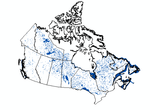
Canada Forest Water (2022)
Wall-to-wall map of water bodies across Canada's forested ecosystems for the year 2022, derived from the "water" class of the annual Virtual Land Cover of Engine (VLCE) product. It is developed within the framework of Canada’s National Terrestrial Ecosystem Monitoring System (NTEMS). The VLCE maps are based on Landsat image time-series composites and represent annual land cover classifications from 1984 to 2022 at a spatial resolution of 30 m. The classification process integrates forest change information and ancillary topographic and hydrologic variables, applying a regional modeling framework based on a 150x150 km tiling system ( Hermosilla et al., 2022). Training data are drawn from multiple land cover sources and selected proportionally to land cover distributions using a distance-weighted approach. Classifications are refined over time using a Hidden Markov Model to ensure consistency and reduce classification noise between years.
Hermosilla, T., Wulder, M.A., White, J.C., Coops, N.C. 2022. Land cover classification in an era of big and open data: Optimizing localized implementation and training data selection to improve mapping outcomes. Remote Sensing of Environment. 268, 112780. https://doi.org/10.1016/j.rse.2021.112780. ( Hermosilla et al., 2022)
Hermosilla, T., Wulder, M.A., White, J.C., Coops, N.C., Hobart, G.W. 2018. Disturbance-Informed Annual Land Cover Classification Maps of Canada's Forested Ecosystems for a 29-Year Landsat Time Series. Canadian Journal of Remote Sensing. 44(1) 67-87. https://doi.org/10.1080/07038992.2018.1437719.( Hermosilla et al., 2018)
Simple
- Date ( RI_367 )
- 2023
- Date ( RI_366 )
- 2023
(250) 363-6004
https://cfs.nrcan.gc.ca/employes/vue/mwulder
- Hours of service
- email only please
- Status
- onGoing; enContinue RI_596
- Maintenance and update frequency
- asNeeded; auBesoin RI_540
- Keywords
-
- National Terrestrial Ecosystem Monitoring System (NTEMS)
- Government of Canada Core Subject Thesaurus Thésaurus des sujets de base du gouvernement du Canada ( RI_528 )
-
- Forests
- Use limitation
- Open Government Licence - Canada (http://open.canada.ca/en/open-government-licence-canada)
- Access constraints
- otherRestrictions; autresRestrictions RI_609
- Use constraints
- intellectualPropertyRights; droitsPropriétéIntellectuelle RI_607
- Spatial representation type
- grid; grille RI_636
- Metadata language
- eng
- Topic category
-
- Geoscientific information
- Begin date
- 2022
- End date
- 2022
))
- Reference system identifier
- http://www.epsg-registry.org / EPSG:3978 / 1.0
- Distribution format
-
-
GeoTIF
(
1.0
)
-
GeoTIF
(
1.0
)
(250) 363-6004
https://ca.nfis.org/index_eng.html
- Hours of service
- email only please
- OnLine resource
-
Satellite Forest Information for Canada (English)
(
HTTPS
)
Application;HTML;eng
- OnLine resource
-
Satellite Forest Information for Canada (French)
(
HTTPS
)
Application;HTML;fra
- OnLine resource
-
Land cover classification in an era of big and open data: Optimizing localized implementation and training data selection to improve mapping outcomes
(
HTTP
)
Supporting Document;HTML;eng
- OnLine resource
-
CA_Water_2022
(
OGC:WMS
)
Web Service;WMS;fra
- OnLine resource
-
CA_Water_2022.zip
(
HTTPS
)
Dataset;ZIP;zxx
- OnLine resource
-
CA_Water_2022
(
OGC:WMS
)
Web Service;WMS;eng
- OnLine resource
-
Disturbance-Informed Annual Land Cover Classification Maps of Canada's Forested Ecosystems for a 29-Year Landsat Time Series
(
HTTPS
)
Supporting Document;PDF;eng
- File identifier
- 0bce352f-6f3f-4a30-9763-c80805fcf272 XML
- Metadata language
- eng; CAN
- Character set
- utf8; utf8 RI_458
- Hierarchy level
- dataset; jeuDonnées RI_622
- Date stamp
- 2026-02-19T13:43:09
- Metadata standard name
- North American Profile of ISO 19115:2003 - Geographic information - Metadata
- Metadata standard version
- CAN/CGSB-171.100-2009
(250) 363-6004
https://cfs.nrcan.gc.ca/employes/vue/mwulder
- Hours of service
- email only please
Overviews
Spatial extent
Provided by
