 Arctic SDI catalogue
Environmental DNA Monitoring in the Eastern Shore Islands Area of Interest - Offshore
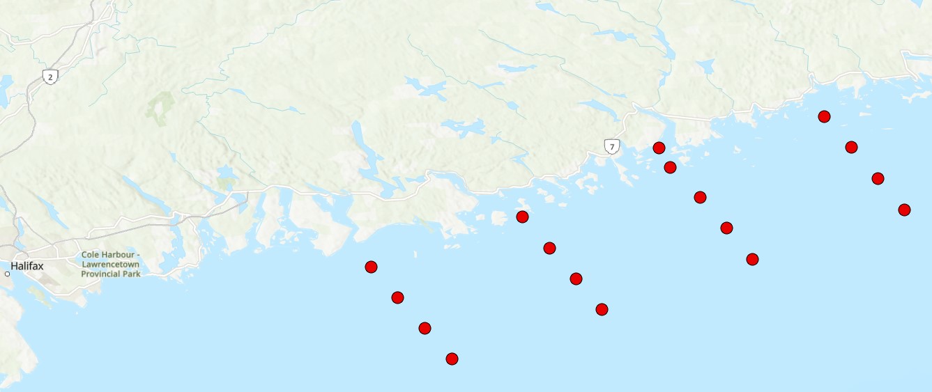
The Eastern Shore Islands Area of Interest (AOI) is a large coastal AOI in the Maritimes Region spanning 2089 km2 and extending along 100 km of coastline. While much of the data that led to the area's designation as an AOI was collected in the nearshore coastal areas (i.e., seagrass and kelp distributions, coastal bird nesting sites, herring spawning areas), there is less information available on the fish and invertebrate community structure in offshore areas of the AOI. Current offshore sampling effort is primarily focused in the Summer multi-species RV survey which covers the Scotian Shelf but does not sample within the depth range covered by the AOI (~ <100m depth). Environmental DNA (eDNA) offers a promising approach for biodiversity monitoring that has been gaining increased attention in the marine realm. Through sampling relatively small volumes of water (~1-5 L), eDNA can capture of millions of fragments of eDNA on filters that can then be sequenced to identify the species composition of an area. eDNA metabarcoding is based on the foundations of DNA barcoding, where species are identified solely by their unique DNA sequences. eDNA metabarcoding relies on a comprehensive reference library of gene sequences from known species to rapidly identify which species are captured in every water sample. This method is relatively simple, efficient (with the ability to characterize both fish and invertebrate diversity), and non-invasive, meaning there is no disruption of sensitive benthic habitats or need to dissect tissue samples from captured fish and invertebrates. eDNA has been shown to be comparable to other biodiversity censusing techniques and has the potential to rapidly conduct biodiversity surveys over a relatively large area, such as the Eastern Shore Islands AOI. Our eDNA sampling in the Eastern Shore Islands targets fish and invertebrates using multiple genetic markers (e.g., 12S and COI) to obtain baseline information on these communities across transects spanning from inshore to offshore in the AOI. Over time, we will investigate changes in species richness and community composition using annual eDNA surveys as an ongoing monitoring tool for this coastal region.
Cite this data as: Jeffery, N.W. Environmental DNA Monitoring in the Eastern Shore Islands Area of Interest - Offshore. Published: April 2026. Coastal Ecosystems Science Division, Maritimes Region, Fisheries and Oceans Canada, Dartmouth NS.
Simple
- Date ( RI_367 )
- 2026-03-16
- Date ( RI_366 )
- 2025-11-28
- Status
- onGoing; enContinue RI_596
- Maintenance and update frequency
- notPlanned; nonPlanifié RI_542
- Keywords
-
- Marine Conservation Target
- Partnerships
- Government of Canada Core Subject Thesaurus Thésaurus des sujets de base du gouvernement du Canada ( RI_528 )
-
- Marine conservation areas
- Genetics
- Oceans
- Use limitation
- Open Government Licence - Canada (http://open.canada.ca/en/open-government-licence-canada)
- Access constraints
- license; licence RI_606
- Use constraints
- license; licence RI_606
- Classification
- unclassified; nonClassifié RI_484
- Spatial representation type
- vector; vecteur RI_635
- Metadata language
- eng; CAN
- Character set
- utf8; utf8 RI_458
- Topic category
-
- Oceans
- Biota
- Environment
- Begin date
- 2022-08-06
- End date
- 2022-08-10
))
- Reference system identifier
- https://epsg.io / EPSG:4326 / 8.2.6
- Distribution format
-
-
ESRI REST
(
2.9.8
)
-
CSV
(
1
)
-
FGDB/GDB
(
2.9.8
)
-
other
(
1
)
-
ESRI REST
(
2.9.8
)
- OnLine resource
-
Metabarcoding results from the12S marker
(
HTTPS
)
Dataset;ZIP;eng
- OnLine resource
-
Metabarcoding results from the 16S marker
(
HTTPS
)
Dataset;ZIP;eng
- OnLine resource
-
Metabarcoding results from the COI marker
(
HTTPS
)
Dataset;ZIP;eng
- OnLine resource
-
12S raw sequences
(
HTTPS
)
Dataset;ZIP;zxx
- OnLine resource
-
16S raw sequences
(
HTTPS
)
Dataset;ZIP;zxx
- OnLine resource
-
COI raw sequences
(
HTTPS
)
Dataset;ZIP;zxx
- OnLine resource
-
Environmental DNA Monitoring in the Eastern Shore Islands Area of Interest - Offshore
(
ESRI REST: Map Service
)
Web Service;ESRI REST;eng
- OnLine resource
-
Environmental DNA Monitoring in the Eastern Shore Islands Area of Interest - Offshore
(
ESRI REST: Map Service
)
Web Service;ESRI REST;fra
- OnLine resource
-
Sampling station metadata from 2022
(
HTTPS
)
Dataset;CSV;eng,fra
- OnLine resource
-
Sampling station metadata from 2022
(
HTTPS
)
Dataset;FGDB/GDB;eng,fra
- OnLine resource
-
Data dictionary
(
HTTPS
)
Supporting Document;CSV;eng,fra
- File identifier
- 0fe7b19d-864c-47fa-b533-c38a09519f9d XML
- Metadata language
- eng; CAN
- Character set
- utf8; utf8 RI_458
- Hierarchy level
- dataset; jeuDonnées RI_622
- Date stamp
- 2026-03-25T09:54:31.411409Z
- Metadata standard name
- North American Profile of ISO 19115:2003 - Geographic information - Metadata
- Metadata standard version
- CAN/CGSB-171.100-2009
Overviews
Spatial extent
Provided by
