 Arctic SDI catalogue
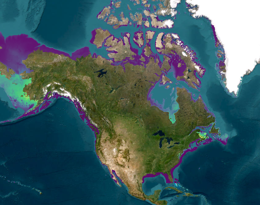
Updated Species Distribution Models for Marine Invasive Species Hotspot Identification
Monitoring data from DFO invasive species monitoring programs, along with occurrence information from online databases and the scientific literature, have been paired with high resolution environmental data and oceanographic models in species distribution models that predict present-day and project future distributions of 24 non-indigenous species (NIS) on North America`s east coast, and 31 NIS on its west coast. Future distributions were predicted for 2100, under Representative Concentration Pathway 8.5 from the Intergovernmental Panel on Climate Change’s fifth Assessment Report. Present-day and future richness of these species (i.e., hotspots) have been estimated by summing the occurrence probabilities of NIS. This data set includes the present-day and year 2100 species distribution modeling results for each species, and the estimated species richness.
Cite this data as: Lyons DA., Lowen JB, Therriault TW., Brickman D., Guo L., Moore AM., Peña MA., Wang Z., DiBacco C. Data of: Updated species distribution models for marine invasive species hotspot identification. Published: November 2023. Coastal Ecosystems Science Division, Fisheries and Oceans Canada, Dartmouth, N.S. https://open.canada.ca/data/en/dataset/1439dcb3-82a6-40fd-a9a4-8f045b20ff5b
Simple
- Date ( RI_367 )
- 2023-11
- Date ( RI_366 )
- 2022-11-08
- Status
- completed; complété RI_593
- Maintenance and update frequency
- notPlanned; nonPlanifié RI_542
- Keywords ( RI_528 )
-
- Aquatic Invasive Species
- Government of Canada Core Subject Thesaurus Thésaurus des sujets de base du gouvernement du Canada ( RI_528 )
-
- Oceans
- Classification
- unclassified; nonClassifié RI_484
- Use limitation
- Open Government Licence - Canada (http://open.canada.ca/en/open-government-licence-canada)
- Access constraints
- license; licence RI_606
- Use constraints
- license; licence RI_606
- Spatial representation type
- grid; grille RI_636
- Metadata language
- eng; CAN
- Character set
- utf8; utf8 RI_458
- Topic category
-
- Oceans
- Environment
- Begin date
- 1857-01-02
- End date
- 2100-12-31
))
- Reference system identifier
- http://www.epsg-registry.org / EPSG:4326 / 8.2.6
- Distribution format
-
-
ESRI REST
(
2.8.8
)
-
TIFF
(
N/A
)
-
CSV
(
N/A
)
-
PDF
(
N/A
)
-
ESRI REST
(
2.8.8
)
- OnLine resource
-
Updated Species Distribution Models for Marine Invasive Species Hotspot Identification
(
HTTPS
)
Dataset;TIFF;zxx
- OnLine resource
-
Updated Species Distribution Models for Marine Invasive Species Hotspot Identification
(
ESRI REST: Map Service
)
Web Service;ESRI REST;eng
- OnLine resource
-
Updated Species Distribution Models for Marine Invasive Species Hotspot Identification
(
ESRI REST: Map Service
)
Web Service;ESRI REST;fra
- OnLine resource
-
Data Dictionary
(
HTTPS
)
Supporting Document;PDF;eng,fra
- File identifier
- 1439dcb3-82a6-40fd-a9a4-8f045b20ff5b XML
- Metadata language
- eng; CAN
- Character set
- utf8; utf8 RI_458
- Hierarchy level
- dataset; jeuDonnées RI_622
- Date stamp
- 2025-02-11T01:21:31.524Z
- Metadata standard name
- North American Profile of ISO 19115:2003 - Geographic information - Metadata
- Metadata standard version
- CAN/CGSB-171.100-2009
Overviews
Spatial extent
Provided by
