 Arctic SDI catalogue
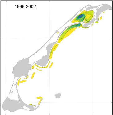
Areas of importance for spring herring in the Magdalen Islands
This cartographic dataset of areas of importance for spring herring in the Magdalen Islands was produced by Fisheries and Oceans Canada (DFO) and the Magdalen Islands ZIP Committee, as part of the work to characterize the Magdalen Islands Lagoons Marine Refuge. The initiative aimed to document fishermen's ecological knowledge of spring herring, including good fishing areas and spawning grounds around the archipelago.
The data comes from interviews conducted between January and April 2024 with the most experienced fishermen in the archipelago. During the interviews, participants identified directly on digital maps the locations associated with four types of observations made throughout their careers:
• Question 8 — Good fishing sites;
• Question 9 — Other observations of high concentrations of the resource;
• Question 13a — Spawning areas and;
• Question 13b — Other observations of signs of spawning.
To facilitate temporal contextualization, a four-period timeline (before 1996, 1996-2002, 2003-2006, and 2007-2021) was used.
The final product is a GeoPackage (.gpkg) containing 16 vector layers composed of four layers per observation type, each corresponding to one of the defined time periods. The polygons were classified according to the number of fishermen who reported each location, making it possible to assess the degree of overlap and the relative importance of the areas over time. The data are projected in NAD83 / MTM zone 4.
For more information on the methodology and data, see Burbank et al. (2025). Additional information specific to the Magdalen Islands lagoons is presented in Grégoire et al. (2026).
Simple
- Date ( RI_367 )
- 2026-03
- Date ( RI_366 )
- 2026-03
- Status
- completed; complété RI_593
- Maintenance and update frequency
- notPlanned; nonPlanifié RI_542
- Keywords
-
- Atlantic Herring
- Clupea harengus
- Spring
- Magdalen Islands
- Fishery
- Spawn
- Local ecological knowledge
- Marine conservation
- Government of Canada Core Subject Thesaurus Thésaurus des sujets de base du gouvernement du Canada ( RI_528 )
-
- Oceans
- Fisheries
- Use limitation
- Open Government Licence - Canada (http://open.canada.ca/en/open-government-licence-canada)
- Access constraints
- license; licence RI_606
- Use constraints
- license; licence RI_606
- Classification
- unclassified; nonClassifié RI_484
- Spatial representation type
- vector; vecteur RI_635
- Metadata language
- fra; CAN
- Topic category
-
- Biota
- Begin date
- 2024-01
- End date
- 2026-09
- Description
- Magdalen Islands
))
- Reference system identifier
- NAD83 / MTM zone 4 / EPSG:32184
- Distribution format
-
-
GPKG
(
1
)
-
GPKG
(
1
)
- OnLine resource
-
Data dictionary for important spring Herring zones
(
HTTPS
)
Supporting Document;CSV;eng,fra
- OnLine resource
-
Supplementary documentation
(
HTTPS
)
Supporting Document;PDF;eng,fra
- OnLine resource
-
Data on important areas for spring Herring
(
HTTPS
)
Dataset;GPKG;eng,fra
- OnLine resource
-
Map service important spring herring zones
(
ESRI REST: Map Service
)
Web Service;ESRI REST;eng
- OnLine resource
-
Map service important spring herring zones
(
ESRI REST: Map Service
)
Web Service;ESRI REST;fra
- File identifier
- 1bab335e-2f3f-4469-98f4-dd10e81c4d30 XML
- Metadata language
- eng; CAN
- Character set
- utf8; utf8 RI_458
- Hierarchy level
- dataset; jeuDonnées RI_622
- Date stamp
- 2026-05-13T14:53:37.376948Z
- Metadata standard name
- North American Profile of ISO 19115:2003 - Geographic information - Metadata
- Metadata standard version
- CAN/CGSB-171.100-2009
Overviews
Spatial extent
Provided by
