 Arctic SDI catalogue
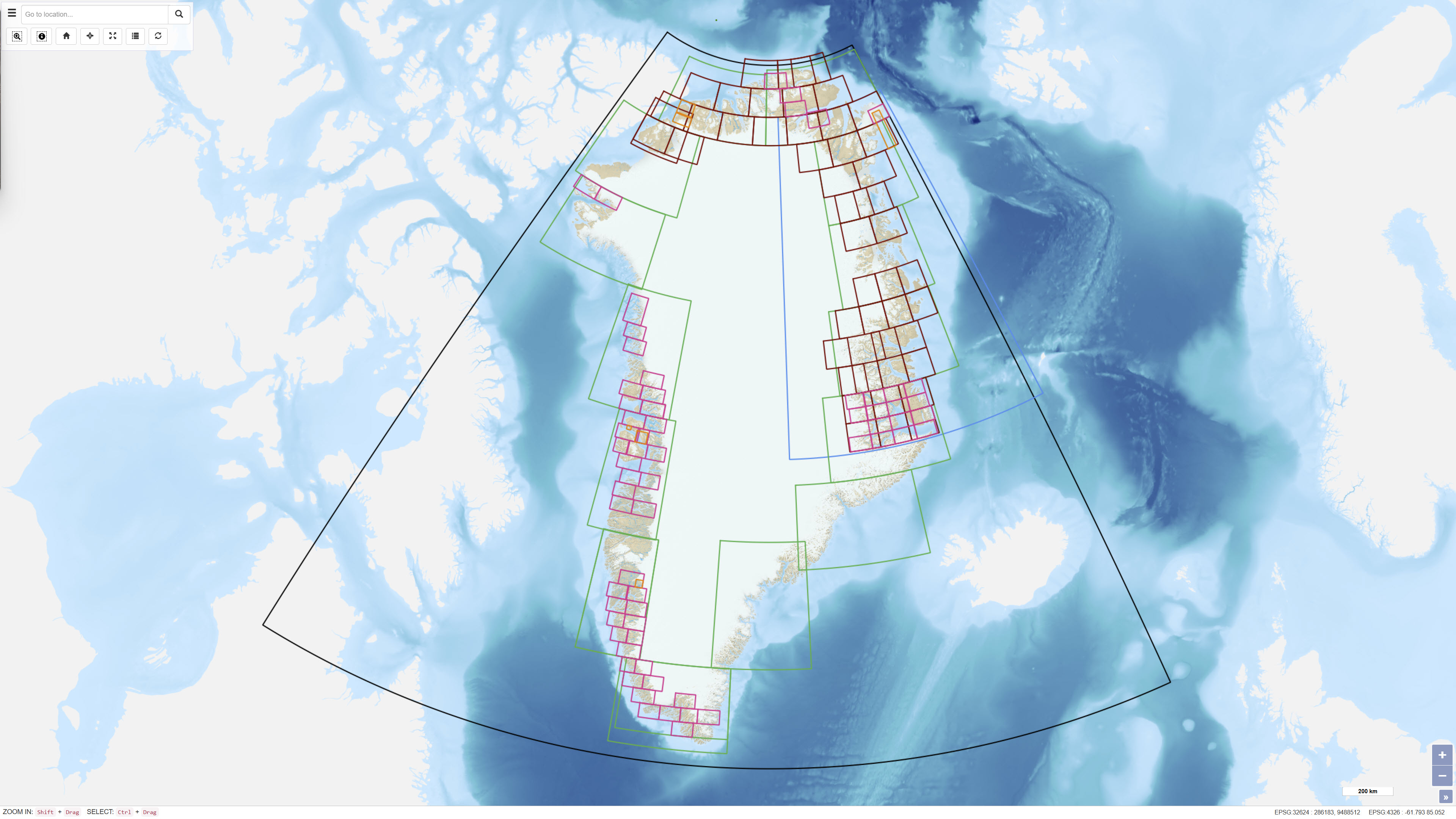
Index Layer of Published Geological Maps of Greenland
Simple
- Date ( Publication )
- 2022-01-01
- Identifier
- dk.geus / grl_published_geological_maps_index
- Presentation form
- Digital map
- Purpose
- The purpose of the dataset is to enable users to locate, identify and access published geological maps of Greenland through a geographic search interface and to support structured access to digital map publications.
- Status
- On going
- Maintenance and update frequency
- As needed
- Keywords ( Theme )
-
- Dataset
- Geological Maps
- Published Maps
- Map Index
- Greenland
- Archive
- Forskningsemner Forskningsemner ( Theme )
- Geografisk Geografisk ( Place )
- Access constraints
- Other restrictions
- Use constraints
- Other restrictions
- Other constraints
- CC BY 4.0
- Other constraints
- The dataset functions as an index of published maps. Rights and terms of use for individual maps are specified in the GEUS Dataverse and associated DOI records.
- Spatial representation type
- Vector
- Denominator
- 500000
- Metadata language
- en
- Character set
- UTF8
- Topic category
-
- Geoscientific information
))
- Supplemental Information
- SUPPLEMENTAL INFORMATION HERE...
- Reference system identifier
- WGS 84 / UTM 24N (EPSG:32624)
- Distribution format
-
-
WMS
(
)
-
WMS
(
)
- OnLine resource
-
Download
(
WWW:DOWNLOAD-1.0-http--download
)
Download scanned maps from GEUS' Dataverse
- OnLine resource
-
Interactive webmap
(
WWW:LINK-1.0-http--link
)
Interactive map displaying the dataset.
- OnLine resource
-
gg_maparchive_published
(
OGC:WMS-1.3.0-http-get-capabilities
)
WMS for published map polygons
- OnLine resource
-
ms:gg_maparchive_published
(
OGC:WFS-1.0.0-http-get-capabilities
)
WFS for published map polygons
- OnLine resource
-
Download
Download dataset as shapefile
- OnLine resource
-
Download
Download dataset as GeoJSON
- Hierarchy level
- Dataset
- Statement
- The dataset has been established as a digital index layer based on records of geological maps published by GGU and GEUS. Geographic outlines have been digitised or registered to represent the spatial coverage of each published map. Each map entry is linked to a DOI in the GEUS Dataverse, where the digital version of the publication can be accessed and downloaded. The dataset does not contain the original map data.
- File identifier
- 1fea0278-d609-4f83-943c-12a8b3b0a14e XML
- Metadata language
- Danskda
- Character set
- UTF8
- Hierarchy level
- Dataset
- Date stamp
- 2026-03-03T13:54:01.387963Z
- Metadata standard name
- ISO 19115:2003/19139
- Metadata standard version
- 1.0
Overviews
Spatial extent
Provided by
