 Arctic SDI catalogue
CGDI Analysis Ready Data Service Kits
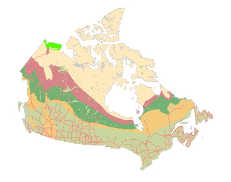
The "Starter Kits" of the Canadian Geospatial Data Infrastructure (CGDI) are curated bundles of geospatial data delivered as a service. These kits are the result of a user needs assessment commissioned by Natural Resources Canada (NRCan), with a primary focus on addressing the specific requirements of Indigenous Peoples. Within these kits, you'll discover a selection of data provided as a service from a collection of over 71,000 datasets falling under the "Nature and Environment" category sourced from CGDI's Federal and Provincial/Territorial partners. These Starter Kits have been thoughtfully crafted into four thematic or geographic areas of Canada:
a) British Columbia,
b) Northwest Territories,
c) Climate Change across Canada,
d) And Water Resources across Canada.
Each of these kits represents diverse areas and data categories, offering new users a compact, comprehensive, and user-friendly gateway to explore a wide array of information provided by the CGDI.
Simple
- Date ( RI_367 )
- 2021-02
- Date ( RI_366 )
- 2020-03
- Status
- completed; complété RI_593
- Maintenance and update frequency
- notPlanned; nonPlanifié RI_542
- Government of Canada Core Subject Thesaurus Thésaurus des sujets de base du gouvernement du Canada ( RI_528 )
-
- Hydrology
- Topography
- Land cover
- Coastal waters
- Climate change
- Meteorology
- Surface water
- Mining industry
- Petroleum industry
- Ice
- Satellite imagery
- Gasoline
- Infrastructures
- Boundaries
- Air quality
- Habitats
- Internet
- Water quality
- Coasts
- Inuit
- Game (Wildlife)
- Conservation areas
- Water
- Precipitation
- Groundwater
- Atlases
- Aquatic animals
- Services
- Oceanography
- Greenhouse gases
- Natural disasters
- Agriculture
- Climate
- Satellite images
- Forestry
- Indigenous peoples
- Land management
- Arctic
- Snow
- Use limitation
- Open Government Licence - Canada (http://open.canada.ca/en/open-government-licence-canada)
- Access constraints
- license; licence RI_606
- Use constraints
- license; licence RI_606
- Spatial representation type
- vector; vecteur RI_635
- Metadata language
- eng; CAN
- Topic category
-
- Geoscientific information
- Begin date
- 2024-01
- End date
- 2024-01
))
- Reference system identifier
- http://www.epsg-registry.org / EPSG:3978 /
- Distribution format
-
-
GPKG
(
unknown
)
-
MXD
(
unknown
)
-
GPKG
(
unknown
)
- OnLine resource
-
4. CGDI Starter Kits National Spatial Water Resource Data GeoPackage English
(
HTTPS
)
Dataset;GPKG;eng
- OnLine resource
-
4. CGDI Starter Kits National Spatial Water Resource Data Map Package English (.MPKX)
(
HTTPS
)
Dataset;other;eng
- OnLine resource
-
2. CGDI Starter Kits Technical Troubleshooting English
(
HTTPS
)
Supporting Document;PDF;eng
- OnLine resource
-
4. CGDI Starter Kits Territorial Spatial Data NWT GeoPackage English
(
HTTPS
)
Dataset;GPKG;eng
- OnLine resource
-
4. CGDI Starter Kits National Spatial Climate Data GeoPackage English
(
HTTPS
)
Dataset;GPKG;eng
- OnLine resource
-
4. CGDI Starter Kits National Spatial Climate Data Map Package English (.MPKX)
(
HTTPS
)
Dataset;other;eng
- OnLine resource
-
3. CGDI Starter Kits National Spatial Climate Data Catalogue English
(
HTTPS
)
Supporting Document;XLSX;eng
- OnLine resource
-
3. CGDI Starter Kits Provincial Data Catalogue English
(
HTTPS
)
Supporting Document;XLSX;eng
- OnLine resource
-
3. CGDI Starter Kits National Spatial Water Resource Data Catalogue English
(
HTTPS
)
Supporting Document;XLSX;eng
- OnLine resource
-
4. CGDI Starter Kits Provincial Spatial Data BC GeoPackage English
(
HTTPS
)
Dataset;GPKG;eng
- OnLine resource
-
4. CGDI Starter Kits Provincial Spatial Data BC Map Package English (.MPKX)
(
HTTPS
)
Dataset;other;eng
- OnLine resource
-
4. CGDI Starter Kits Territorial Spatial Data NWT Map Package English (.MPKX)
(
HTTPS
)
Dataset;other;eng
- OnLine resource
-
5 CGDI Primer French
(
FTP
)
Supporting Document;PDF;fra
- OnLine resource
-
5 CGDI Primer English
(
FTP
)
Supporting Document;PDF;eng
- OnLine resource
-
5 CGDI Factsheet French
(
FTP
)
Supporting Document;PDF;fra
- OnLine resource
-
5 CGDI Factsheet English
(
FTP
)
Supporting Document;PDF;eng
- OnLine resource
-
5 CGDI Cookbook French
(
FTP
)
Supporting Document;PDF;fra
- OnLine resource
-
5 CGDI Cookbook English
(
FTP
)
Supporting Document;PDF;eng
- OnLine resource
-
2. CGDI Starter Kits Technical Troubleshooting French
(
HTTPS
)
Supporting Document;PDF;fra
- OnLine resource
-
1. CGDI Starter Kits Read Me File ArcGIS English
(
HTTPS
)
Supporting Document;PDF;eng
- OnLine resource
-
1. CGDI Starter Kits Read Me File ArcGIS French
(
HTTPS
)
Supporting Document;PDF;fra
- OnLine resource
-
2. CGDI Starter Kits Read Me QGIS English
(
HTTPS
)
Supporting Document;PDF;eng
- OnLine resource
-
2. CGDI Starter Kits Read Me QGIS French
(
HTTPS
)
Supporting Document;PDF;fra
- OnLine resource
-
3. Opening CGDI Data Kits for ArcGIS Pro
(
HTTPS
)
Supporting Document;PDF;eng
- OnLine resource
-
3. Opening CGDI Data Kits for ArcGIS Pro
(
HTTPS
)
Supporting Document;PDF;fra
- File identifier
- 2364749d-70a0-4874-956d-a636401ac5a6 XML
- Metadata language
- eng; CAN
- Character set
- utf8; utf8 RI_458
- Hierarchy level
- dataset; jeuDonnées RI_622
- Date stamp
- 2024-02-06T10:55:57
- Metadata standard name
- North American Profile of ISO 19115:2003 - Geographic information - Metadata
- Metadata standard version
- CAN/CGSB-171.100-2009
Overviews
Spatial extent
Provided by
