 Arctic SDI catalogue
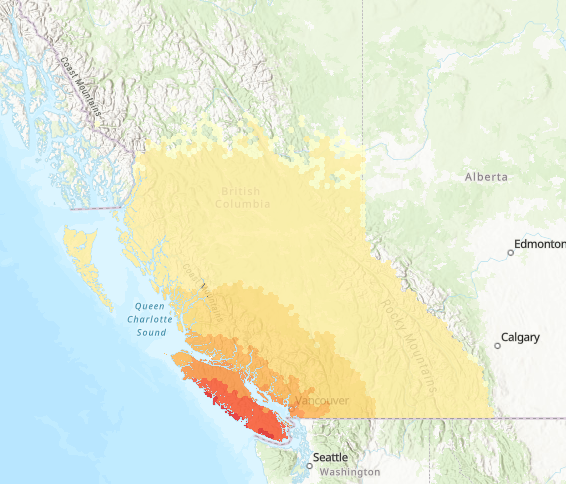
Canada's National Earthquake Scenario Catalogue - Cascadia Interface Best Fault - Magnitude 9.0
Simple
- Date ( RI_367 )
- 2021-07-06
- Date ( RI_366 )
- 2021-07-06
- Status
- onGoing; enContinue RI_596
- Maintenance and update frequency
- asNeeded; auBesoin RI_540
- Government of Canada Core Subject Thesaurus Thésaurus des sujets de base du gouvernement du Canada ( RI_528 )
-
- Earth sciences
- Emergency preparedness
- Earthquakes
- Geological maps
- Use limitation
- Open Government Licence - Canada (http://open.canada.ca/en/open-government-licence-canada)
- Access constraints
- license; licence RI_606
- Use constraints
- license; licence RI_606
- Spatial representation type
- vector; vecteur RI_635
- Metadata language
- eng; CAN
- Topic category
-
- Geoscientific information
- Begin date
- 2021-07-06
))
- Reference system identifier
- http://www.epsg-registry.org / EPSG:4326 /
- Distribution format
-
-
GPKG
(
1.2
)
-
GPKG
(
1.2
)
- OnLine resource
-
GitHub Repository
(
HTTPS
)
Supporting Document;HTML;eng
- OnLine resource
-
Geological Survey of Canada Open File
(
FTP
)
Supporting Document;PDF;eng
- OnLine resource
-
Cascadia Interface Best Fault - Magnitude 9.0 (Points)
(
HTTPS
)
Dataset;GPKG;eng,fra
- OnLine resource
-
Cascadia Interface Best Fault - Magnitude 9.0 (Polygons)
(
HTTPS
)
Dataset;GPKG;eng,fra
- OnLine resource
-
Cascadia Interface Best Fault - Magnitude 9.0 Shake Map
(
HTTPS
)
Dataset;GPKG;eng,fra
- OnLine resource
-
Data Dictionary
(
HTTPS
)
Supporting Document;XLSX;fra
- OnLine resource
-
Data Dictionary
(
HTTPS
)
Supporting Document;XLSX;eng
- OnLine resource
-
M9.0 Cascadia Full Rupture Subduction Earthquake (BC)
(
ESRI REST: Map Server
)
Web Service;ESRI REST;eng
- OnLine resource
-
Séisme de subduction de magnitude 9,0, rupture complète de la faille de Cascadia (Colombie-Britannique)
(
ESRI REST: Map Server
)
Web Service;ESRI REST;fra
- OnLine resource
-
M9.0 Cascadia Full Rupture Subduction Earthquake (BC)
(
OGC:WMS
)
Web Service;WMS;eng
- OnLine resource
-
Séisme de subduction de magnitude 9,0, rupture complète de la faille de Cascadia (Colombie-Britannique)
(
OGC:WMS
)
Web Service;WMS;fra
- File identifier
- 26c57e53-2646-491b-b385-5813b23d8a96 XML
- Metadata language
- eng; CAN
- Character set
- utf8; utf8 RI_458
- Parent identifier
- Canada's National Earthquake Scenario Catalogue 085024ac-5a48-427a-a2ea-d62af73f2142
- Hierarchy level
- series; série RI_623
- Date stamp
- 2023-04-27T16:37:34
- Metadata standard name
- North American Profile of ISO 19115:2003 - Geographic information - Metadata
- Metadata standard version
- CAN/CGSB-171.100-2009
Overviews
Spatial extent
Provided by
