 Arctic SDI catalogue
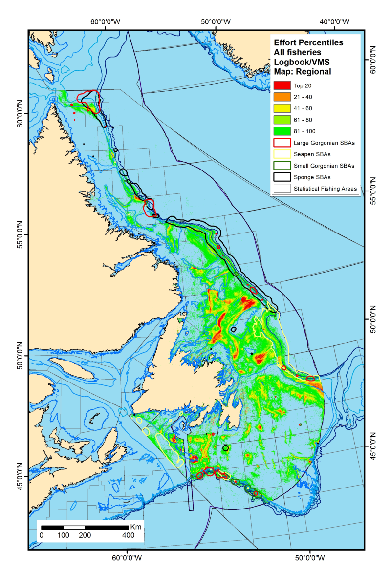
Fishing Effort in Canada’s Atlantic and Eastern Arctic Waters
In 2009, Fisheries and Oceans Canada published the Policy on Managing the Impacts of Fishing on Sensitive Benthic Areas. To support the implementation of this policy, a Canadian Science Advisory Secretariat (CSAS) process was initiated to: assess the distribution of fishing effort in Canada’s Atlantic and Eastern Arctic waters from 2005-2014, evaluate the overlap between fishing effort and Significant Benthic Areas (SiBAs), and identify areas of potential conservation concern. Although Research Document 2018/15 (Koen-Alonso et al. 2018), detailing this work, has not been updated since publication, the methodology outlined within it is still used to generate updated fishing effort layers as new data becomes available.
This record illustrates cumulative fishing effort in Canada’s Atlantic and Eastern Arctic waters from 2005-2023, and is based on commercial logbook and vessel monitoring system (VMS) data. Fishing effort has been standardized into percentiles, whereby the top 20th percentile of intensity (cell values ≥20) represent cells containing the most intense fishing activities.
Simple
- Date ( RI_366 )
- 2018-06-08
- Date ( RI_367 )
- 2024
- Status
- completed; complété RI_593
- Maintenance and update frequency
- notPlanned; nonPlanifié RI_542
- Government of Canada Core Subject Thesaurus Thésaurus des sujets de base du gouvernement du Canada ( RI_528 )
-
- Aquatic animals
- Conservation areas
- Oceans
- Environmental sciences
- Fisheries
- Environmental impact
- Conservation
- Aquatic wildlife
- Marine biology
- Marine conservation areas
- Classification
- unclassified; nonClassifié RI_484
- Use limitation
- Open Government Licence - Canada (http://open.canada.ca/en/open-government-licence-canada)
- Access constraints
- license; licence RI_606
- Use constraints
- license; licence RI_606
- Spatial representation type
- grid; grille RI_636
- Metadata language
- eng; CAN
- Character set
- utf8; utf8 RI_458
- Topic category
-
- Oceans
- Environment
- Begin date
- 2005-01-01
- End date
- 2019-12-31
))
- Reference system identifier
- https://epsg.io / EPSG:3857 /
- OnLine resource
-
Science Advisory Report 2017/007
(
HTTPS
)
Supporting Document;HTML;eng,fra
- OnLine resource
-
Fishing Effort Layers Explained_EN.pdf
(
HTTPS
)
Supporting Document;PDF;eng
- OnLine resource
-
Percentiles_EN.zip
(
HTTPS
)
Dataset;TIFF;eng
- OnLine resource
-
Percentiles_FR.zip
(
HTTPS
)
Dataset;TIFF;fra
- OnLine resource
-
DataDictionary-DictionnaireDonnées_EN.csv
(
HTTPS
)
Supporting Document;CSV;eng
- OnLine resource
-
DataDictionary-DictionnaireDonnées_FR.csv
(
HTTPS
)
Supporting Document;CSV;fra
- OnLine resource
-
Fishing Effort in Canada’s Atlantic and Eastern Arctic Waters (EN)
(
ESRI REST: Map Service
)
Web Service;ESRI REST;eng
- OnLine resource
-
Fishing Effort in Canada’s Atlantic and Eastern Arctic Water (FR)
(
ESRI REST: Map Service
)
Web Service;ESRI REST;fra
- OnLine resource
-
Research Document 2018/015
(
HTTPS
)
Supporting Document;HTML;eng,fra
- OnLine resource
-
Fishing Effort Layers Explained_FR.pdf
(
HTTPS
)
Supporting Document;PDF;eng
- File identifier
- 273df20a-47ae-42c0-bc58-01e451d4897a XML
- Metadata language
- eng; CAN
- Character set
- utf8; utf8 RI_458
- Hierarchy level
- dataset; jeuDonnées RI_622
- Date stamp
- 2025-10-07T15:33:54.9Z
- Metadata standard name
- North American Profile of ISO 19115:2003 - Geographic information - Metadata
- Metadata standard version
- CAN/CGSB-171.100-2009
Overviews
Spatial extent
Provided by
