 Arctic SDI catalogue
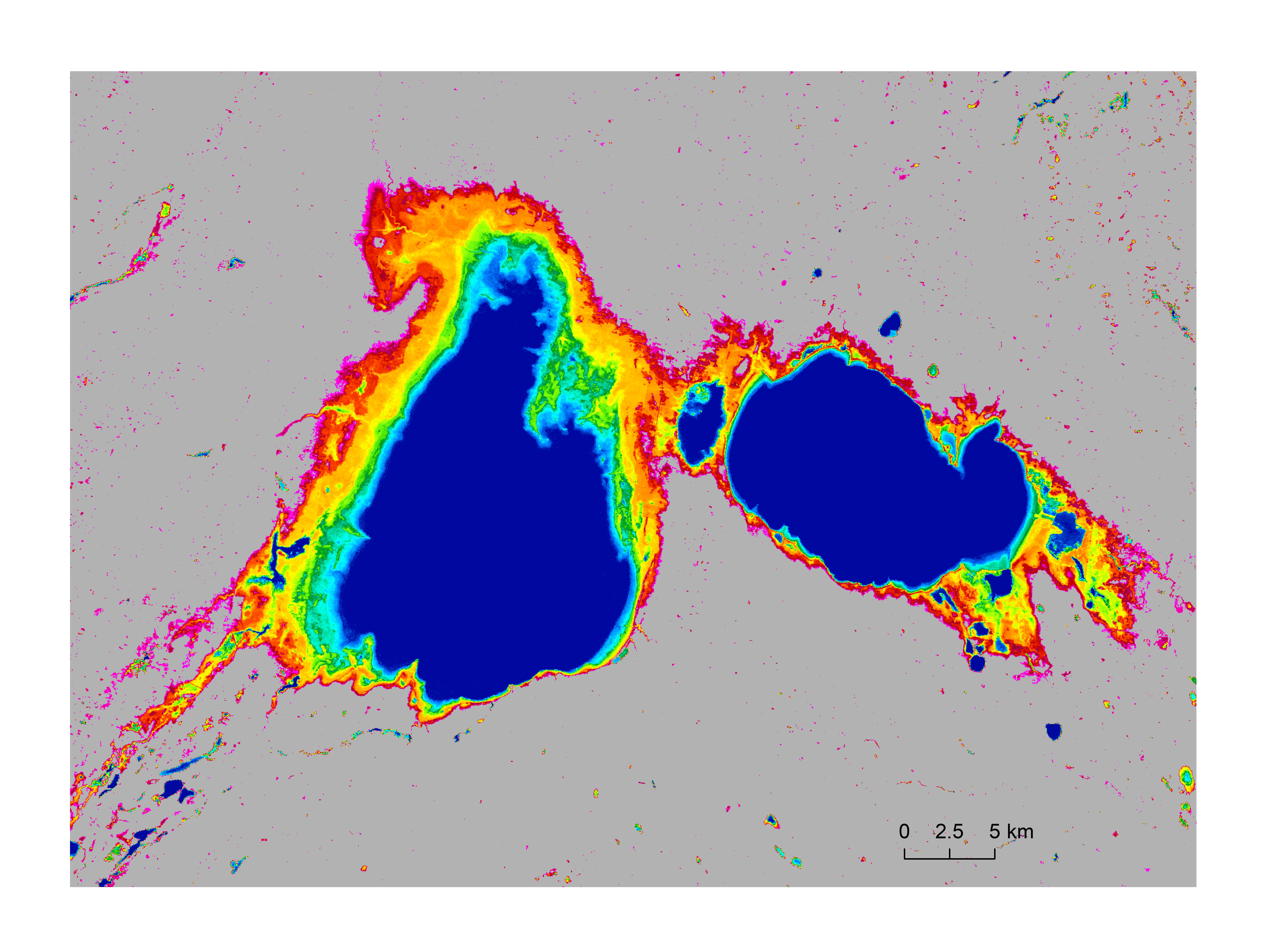
Canada's surface water frequency
Data represents surface water occurrence frequency (percentage), which describes the frequency for each grid appeared as water in the 30 years time period of 1991 to 2020. The data covers Canada’s entire landmass including all transboundary watersheds, and is at 30-meter spatial resolution. The surface water occurrence frequency is derived using the surface water model of Wang et al. (2023) from all-available monthly water data observed by the Landsat satellites (Pekel et al., 2016). Here, permanent waters are represented by 100%, and permanent land surfaces by 0%, of water occurrence for a 30-meter by 30-meter grid.
References:
Pekel, J.-F., A. Cottam, N. Gorelick, A.S. Belward, 2016, High-resolution mapping of global surface water and its long-term changes. Nature, 540, 418-422.
Wang, S., J. Li, and H. A. J. Russell, 2023, Methods for Estimating Surface Water Storage Changes and Their Evaluations. Journal of Hydrometeorology, DOI: https://doi.org/10.1175/JHM-D-22-0098.1.
Simple
- Date ( RI_367 )
- 2023-02-16
- Date ( RI_366 )
- 2023-02-16
- Status
- completed; complété RI_593
- Maintenance and update frequency
- irregular; irrégulier RI_541
- Keywords ( RI_530 )
-
- geoscientific information
- Government of Canada Core Subject Thesaurus Thésaurus des sujets de base du gouvernement du Canada ( RI_528 )
-
- Water
- Remote sensing
- Surface water
- Inland waters
- Lakes
- Hydrology
- Climate
- Databases
- Use limitation
- Open Government Licence - Canada (http://open.canada.ca/en/open-government-licence-canada)
- Access constraints
- license; licence RI_606
- Use constraints
- license; licence RI_606
- Spatial representation type
- grid; grille RI_636
- Metadata language
- eng; CAN
- Topic category
-
- Imagery base maps earth cover
- Begin date
- 1991
- End date
- 2020
))
- Reference system identifier
- http://www.epsg-registry.org / EPSG:3979 /
- Distribution format
-
-
GeoTIF
(
N/A
)
-
WMS
(
1.3.0
)
-
WCS
(
1.1.1
)
-
GeoTIF
(
N/A
)
- OnLine resource
-
STAC API
(
HTTPS
)
API;Web App;eng,fra
- OnLine resource
-
Surface Water Frequency Maps of Canada from 1991-2020
(
OGC:WMS
)
Web Service;WMS;eng
- OnLine resource
-
Surface Water Frequency Maps of Canada from 1991-2020
(
OGC:WMS
)
Web Service;WMS;fra
- OnLine resource
-
Surface Water Frequency Maps of Canada from 1991-2020
(
HTTPS
)
Dataset;TIFF;zxx
- OnLine resource
-
Surface Water Frequency Maps of Canada from 1991-2020
(
HTTPS
)
Web Service;WCS;eng,fra
- File identifier
- 2b76d117-d940-4ebb-bf26-91f768081c5f XML
- Metadata language
- eng; CAN
- Character set
- utf8; utf8 RI_458
- Hierarchy level
- series; série RI_623
- Date stamp
- 2023-05-02T08:46:58
- Metadata standard name
- North American Profile of ISO 19115:2003 - Geographic information - Metadata
- Metadata standard version
- CAN/CGSB-171.100-2009
Overviews
Spatial extent
Provided by
