 Arctic SDI catalogue
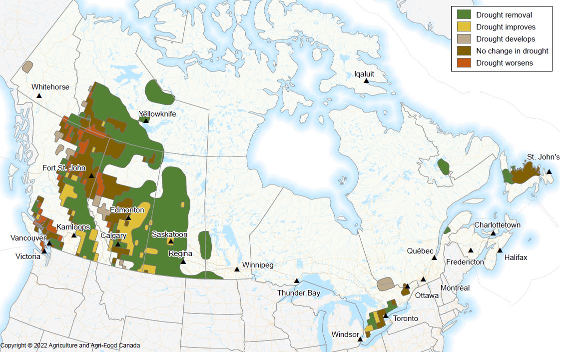
Canadian Drought Outlook
Agriculture is an important primary production sector in Canada. Agricultural production, profitability, sustainability and food security depend on many agrometeorological factors, including drought. The Canadian Drought Outlook predicts whether drought across Canada will emerge, stay the same or get better over the target month. The drought outlook is issued on the first Thursday of each calendar month and is valid for 32 days from that date.
This series of datasets has been created by AAFC’s National Agroclimate Information Service (NAIS) of the Agro-Climate, Geomatics and Earth Observations (ACGEO) Division of the Science and Technology Branch. The Canadian Drought Outlook maps are generated using Environment and Climate Change Canada’s (ECCC) Global Ensemble Prediction (GEPs) forecast data. Agroclimate indices, such as the Standard Precipitation Index (SPI), the Standard Precipitation Evaporation Index (SPEI), and the Palmer Drought Severity Index (PDSI) are calculated using the GEPs forecast data. These indices are then combined with the current Canadian drought assessment to predict future changes in drought.
Simple
- Date ( RI_367 )
- 2020-12-01
- Date ( RI_366 )
- 2020-09-01
- Presentation form
- mapDigital;carteNumérique RI_391
- Status
- onGoing; enContinue RI_596
- Maintenance and update frequency
- daily; quotidien RI_533
- Keywords ( RI_528 )
-
- Drought Forecast
- Government of Canada Core Subject Thesaurus Thésaurus des sujets de base du gouvernement du Canada ( RI_528 )
-
- Climate
- Weather
- Weather forecasts
- Farmlands
- Meteorology
- Temperature
- Agriculture
- Drought
- Use limitation
- Open Government Licence - Canada (http://open.canada.ca/en/open-government-licence-canada)
- Access constraints
- license; licence RI_606
- Use constraints
- license; licence RI_606
- Spatial representation type
- grid; grille RI_636
- Metadata language
- english; french CAN
- Topic category
-
- Climatology, meteorology, atmosphere
- Farming
- Begin date
- 2020-12-04
))
- Reference system identifier
- http://www.epsg-registry.org / EPSG:4326 / 8.3.4
- Distribution format
-
-
FGDB/GDB
(
10.1
)
-
GEOJSON
(
1
)
-
SHP
(
1
)
-
FGDB/GDB
(
10.1
)
- OnLine resource
-
Data Product Specification (English)
(
HTTPS
)
Supporting Document;PDF;eng
- OnLine resource
-
Pre-packaged FGDB files
(
HTTPS
)
Dataset;FGDB/GDB;eng,fra
- OnLine resource
-
Pre-packaged geoJSON files
(
HTTPS
)
Dataset;GEOJSON;eng,fra
- OnLine resource
-
Pre-packaged SHP files
(
HTTPS
)
Dataset;SHP;eng,fra
- OnLine resource
-
Pre-packaged Maps (English)
(
HTTPS
)
Dataset;PDF;eng
- OnLine resource
-
Pre-packaged Maps (French)
(
HTTPS
)
Dataset;PDF;fra
- OnLine resource
-
Canadian Drought Outlook (English)
(
HTTPS
)
Web Service;ESRI REST;eng
- OnLine resource
-
Canadian Drought Outlook (French)
(
HTTPS
)
Web Service;ESRI REST;fra
- OnLine resource
-
Data Product Specification (French)
(
HTTPS
)
Supporting Document;PDF;fra
- File identifier
- 2c82daab-f6d9-4b19-96b5-238249e09fb9 XML
- Metadata language
- eng; CAN
- Character set
- utf8; utf8 RI_458
- Hierarchy level
- dataset; jeuDonnées RI_622
- Date stamp
- 2022-12-19T13:25:42
- Metadata standard name
- North American Profile of ISO 19115:2003 - Geographic information - Metadata
- Metadata standard version
- CAN/CGSB-171.100-2009
Overviews
Spatial extent
Provided by
