 Arctic SDI catalogue
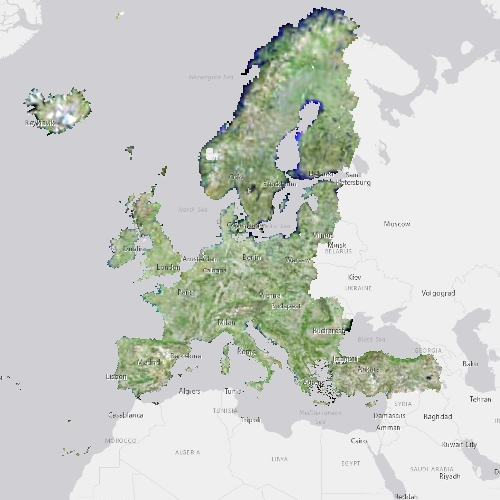
Pan-European Very High Resolution Image Mosaic 2012 - True Colour (2,5 m), June 2015
The pan-European Very High Resolution (VHR) Image Mosaic 2012 provides optical VHR2 (Very High Resolution: > 1m and <= 4m) coverage over Europe.
The surface covered by the image dataset is 7,3 million square kilometres and has a spatial resolution of 2,5 m. The acquisition window of the imagery is January 2011 to December 2013. Images are derived from the following satellite sensors:
• SPOT-5 at 2.5m pan-sharpened
• SPOT-6 at 1.5 m pan-sharpened
• FORMOSAT-2 at 2m pan-sharpened
The mosaic primarily is used as input data in the production of various Copernicus Land Monitoring Service (CLMS) datasets and services, such as land cover maps and high resolution layers on land cover characteristic and can be also useful for CLMS users for visualizations and classifications on land.
The input imagery for the creation of the mosaic is provided by ESA. Due to license restrictions, VHR Image Mosaic 2012 is only available as a web service (WMS), and not for data download.
Simple
- Date ( Creation )
- 2015-06-18T00:00:00
- Date ( Publication )
- 2015-06-18T00:00:00
- Edition
- 01.00
- Identifier
- copernicus_r_3035_2-5_m_vhrim-tc-2012_i_2011-2013_v01_r00
- Maintenance and update frequency
- As needed
- GEMET - INSPIRE themes, version 1.0 ( Theme )
- Keywords
-
- Keywords
-
- GEMET ( Theme )
-
- mosaic
- environmental policy
- general
- satellite image
- raster
- Continents, countries, sea regions of the world. ( Place )
-
- EEA38 (from 2020)
- United Kingdom
- Spatial scope ( Theme )
-
- European
- Temporal resolution ( Temporal )
-
- As needed
- EEA topics ( Theme )
-
- Land use
- Access constraints
- Other restrictions
- Other constraints
- no limitations to public access
- Use constraints
- Other restrictions
- Other constraints
-
The Copernicus component is governed by Regulation (EU) No 2021/696 of the European Parliament and of the Council of 28 April 2021 establishing the Union Space Programme and the European Union Agency for the Space Programme and repealing Regulations (EU) No 912/2010, (EU) No 1285/2013 and (EU) No 377/2014 and Decision No 541/2014/EU. Within the Copernicus component, a portfolio of land monitoring activities has been delegated by the European Union to the European Environment Agency (EEA) and the DG Joint Research Centre of the European Commission.
The Copernicus land monitoring products and services are made available on a principle of full, open and free access, as established by the Commission Delegated Regulation (EU) No 1159/2013 of 12 July 2013.
Free, full and open access to the products and services of the Copernicus Land Monitoring Service is made on the conditions that:
1. When distributing or communicating Copernicus Land Monitoring Service products and services (data, software scripts, web services, user and methodological documentation and similar) to the public, users shall inform the public of the source of these products and services.
2. Where the Copernicus Land Monitoring Service products and services have been adapted or modified by the user, the user shall clearly state this.
3. Users shall make sure not to convey the impression to the public that the user's activities are officially endorsed by the European Union.
- Spatial representation type
- grid Grid
- Distance
- 2.5 m
- Metadata language
- en
- Topic category
-
- Environment
- Imagery base maps earth cover
))
- Begin date
- 2011-01-01
- End date
- 2013-12-31
- Unique resource identifier
- EPSG:3035
- Distribution format
-
-
GeoTIFF
(
)
-
GeoTIFF
(
)
- OnLine resource
- Product Information & Technical Documentation ( WWW:LINK )
- OnLine resource
- https://copernicus.discomap.eea.europa.eu/arcgis/rest/services/GioLand/VeryHighResolution2012/MapServer ( ESRI:REST )
- Hierarchy level
- Dataset
Conformance result
- Date ( Publication )
- 2010-12-08
- Explanation
- See the referenced specification
- Statement
-
The source data are based mainly on Spot-5 scenes, with additional SPOT-6 scenes over northern Europe, provided by Astrium/Airbus DS. The original SPOT-5 data allow only a display in false-colour band combination due to the missing blue band. For the usage inside a public view services however a natural-colour-like display is strongly preferred. The JRC processed the Core003 source data and created a seamless mosaic with a natural-colour display, calculating the blue band based on the available bands. A cloud-free optimization and histogram equalization were applied for best visual impression in a view service.
The SPOT-5 2,5 m product is constructed out of the 5 m pan and 10 m MS (and 20 m on SWIR) of SPOT-5. It is obtained by merging two separate images, one in panchromatic mode at 2,5 m resolution and the other in three-band multispectral mode at 10-metre resolution. The 2,5 m image is itself generated by merging two 5 m images, for which one of the HRG instruments has to acquire three images simultaneously to produce a 2,5 m colour image. Images thus obtained are like a three-band colour image, with a resolution of 2,5 m and panchromatic viewing geometry.
• Cloud coverage: ≤ 5% per NUTS unit, (mostly).
• Without haze
• Seasonal snow
• 1% max saturated pixels.
• 8 bit per pixel
• Maximum Instrument Incidence angle 20° (upon criticality of acquisition success extension to 30° may be added to increase probability of success). L3/Orthorectified with geolocation accuracy <5 m RMSE.
- File identifier
- 2d291b41-9ec8-4bf7-9582-b24c130deffe XML
- Metadata language
- en
- Character set
- UTF8
- Hierarchy level
- Dataset
- Date stamp
- 2025-10-09T10:43:12.218333Z
- Metadata standard name
- ISO 19115/19139
- Metadata standard version
- 1.0
Overviews
Spatial extent
Provided by
