 Arctic SDI catalogue
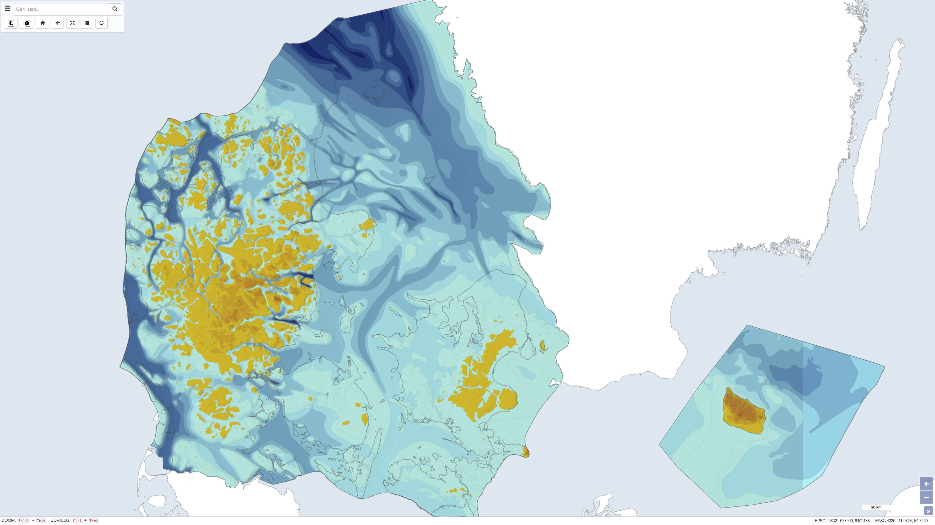
Pre-Quaternary surface topography of Denmark – Geological map of Denmark 1:500.000
Simple
- Date ( Publication )
- 1993-12-12
- Identifier
- dk.geus / praekvartaer_hoejdeforhold
- Presentation form
- Digital map
- Purpose
- The purpose of this dataset is to depict the topography of the pre-Quaternary surface in Denmark before Quaternary sediment deposition, providing a geologically informed basis for geological, hydrogeological and geotechnical analysis. The dataset is used for assessing Quaternary cover thickness, structural interpretation and as reference in subsurface models.
- Status
- Completed
- Maintenance and update frequency
- As needed
- Keywords ( Theme )
-
- Dataset
- Geology
- Pre-Quaternary
- Topography
- Denmark
- Subsurface
- ArcGIS
- QGIS
- Forskningsemner Forskningsemner ( Theme )
- Geografisk Geografisk ( Place )
- Access constraints
- Other restrictions
- Use constraints
- Other restrictions
- Other constraints
- CC0 1.0
- Spatial representation type
- Grid
- Denominator
- 500000
- Metadata language
- Da
- Character set
- UTF8
- Topic category
-
- Geoscientific information
- Elevation
- Begin date
- 1926-01-01
- End date
- 1993-12-19
))
- Supplemental Information
- The dataset relies on traditional hand-drawn map compilations at 1:250,000 scale digitized for modern use. It depicts the elevation of the sub-Quaternary surface and is particularly useful when combined with standard elevation models for cover thickness assessment, as well as in geotechnical and hydrogeological modelling.
- Reference system identifier
- ETRS 89 / UTM 32N (EPSG:25832)
- Distribution format
-
-
WMS
(
)
-
Rest
(
)
-
WMTS
(
)
-
WMS
(
)
- OnLine resource
-
Download
(
WWW:DOWNLOAD-1.0-http--download
)
Download dataset from GEUS' Dataverse
- OnLine resource
-
Interactive webmap
(
WWW:LINK-1.0-http--link
)
Interactive map displaying the dataset.
- OnLine resource
-
DGU map series No. 44, 1994
(
DOI
)
Geological map of Denmark. Geological map of Denmark 1:500 000. Altitude ratio of the Pre-Quaternary surface. The Danish land area as well as the Kattegat, inland waters and the waters around Bornholm. Denmark's pre-Quaternary surface topography
- OnLine resource
-
Hojdeforhold
(
OGC:WMS-1.3.0-http-get-capabilities
)
ArcGIS WMS Service
- OnLine resource
-
Praekvartaer_hoejdeforhold
(
ESRI:REST
)
ArcGIS REST Service
- OnLine resource
-
Denmark_Praekvartaer_hoejdeforhold
(
OGC:WMTS-1.0.0-http-get-capabilities
)
ArcGIS WMTS Service
- Hierarchy level
- Dataset
- Statement
- The dataset is documented in DGU Map Series no. 44, published by the Geological Survey of Denmark in 1993/1994 with ISBN 87-89640-98-1 and DOI 10.22008/FK2/TZLEKA/LAEPNZ. The map portrays pre-Quaternary topography based on borehole records from the DGU Bore Archive, seismic surveys, and topographic control. It results from consolidated geological and geophysical data to produce a nationwide paleotopographic map. Further revisions may be incorporated as new borehole and geophysical information becomes available.
- File identifier
- 2eb3b1d3-ff45-40f7-99e1-f55ca42efaf2 XML
- Metadata language
- Danskda
- Character set
- UTF8
- Hierarchy level
- Dataset
- Date stamp
- 2026-03-19T14:45:59.433565Z
- Metadata standard name
- ISO 19115:2003/19139
- Metadata standard version
- 1.0
Overviews
Spatial extent
Provided by
