 Arctic SDI catalogue
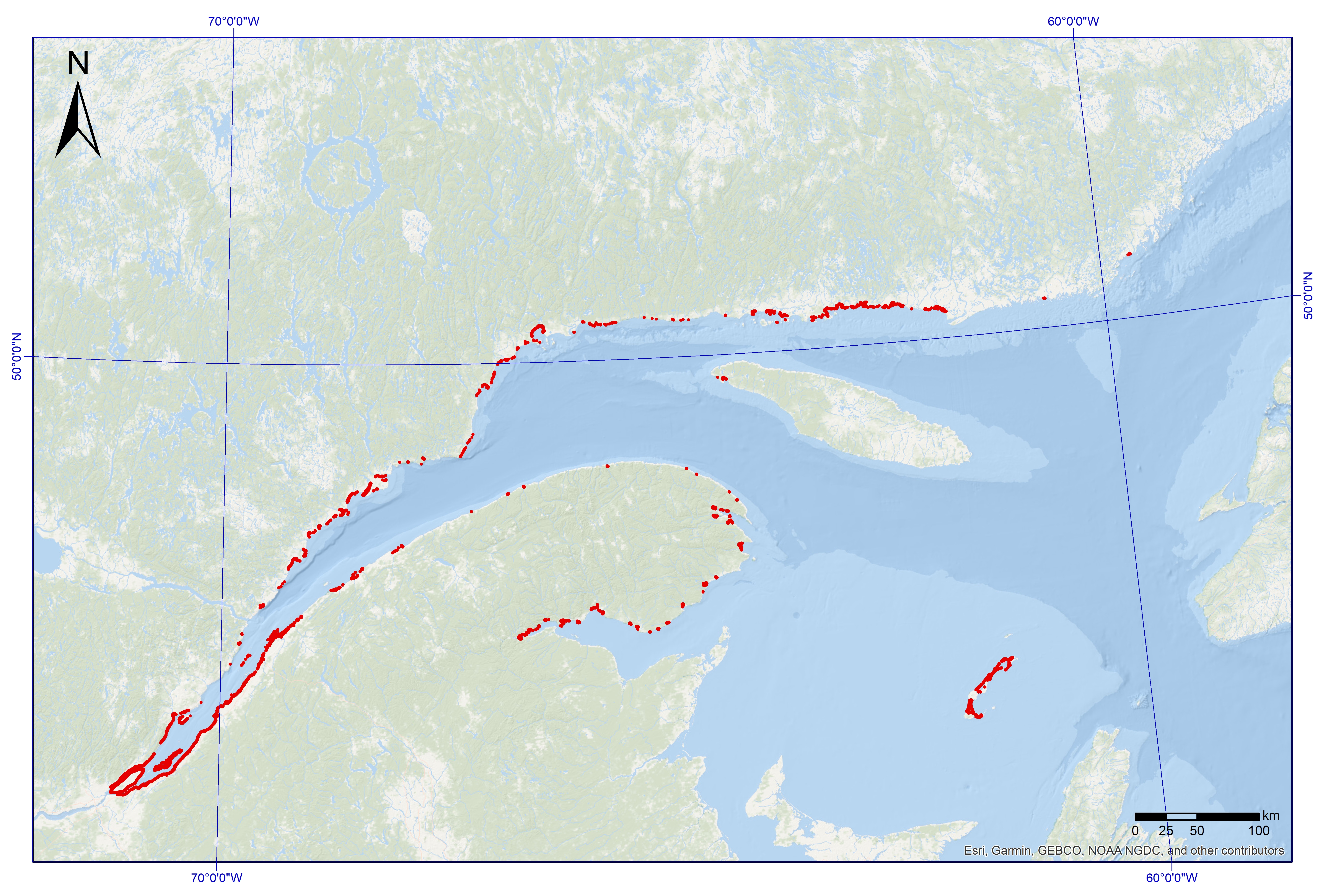
Tidal marshes in the maritime coastal zone of Quebec
This dataset was designed for Environment and Climate Change Canada's (ECCC) National Environmental Emergencies Center (NEEC) for oil spill preparedness and response. The polygons from this layer come from the coastal ecosystems geodatabase as part of the Mapping of coastal ecosystems of the Estuary and Gulf of St. Lawrence project. This layer represents semi-vegetated (25-75%) and vegetated (75-100%) zones of which marsh vegetation is the dominant. The study area includes all of the estuarine and maritime coasts of Quebec, with the exception of certain sectors, including most of the Lower North Shore and Anticosti Island, with the exception of villages of Kegaska, la Romaine, Chevery, Blanc-Sablon and Port-Menier. Some islands off the estuary and gulf coasts are part of the region covered, such as Île d'Orléans, Isle-aux-Coudres, Île Verte and Île Bonaventure.
The mapping of coastal ecosystems was carried out jointly by the Laboratory for Dynamics and Integrated Coastal Zone Management (LDGIZC) of the University of Quebec at Rimouski as part of the Coastal Resilience Project (https: //ldgizc.uqar.ca/Web/projets/projet-resilience-cotiere) funded by the MELCC; and by the Fisheries and Oceans Canada team, as part of its Integrated marine response planning (IMRP) component of the Oceans Protection Plan (OPP), with the objective of updating the Marine Oil Spill Preparedness and Response Regime of Canada. The master geodatabase of coastal ecosystems is hosted and distributed by UQAR on their SIGEC-Web mapping platform: https://ldgizc.uqar.ca/Web/sigecweb
The characterization of marshes was mainly carried out using photo-interpretation of RVBI aerial photos acquired by DFO (2015-2020) and oblique photos taken by helicopter acquired by UQAR in 2017. This dataset also includes the information from validation stations visited by UQAR (2018-2020), used to validate and refine the photo-interpretation.
Simple
- Date ( RI_367 )
- 2024-03-11
- Date ( RI_366 )
- 2024-03-11
- Status
- completed; complété RI_593
- Maintenance and update frequency
- asNeeded; auBesoin RI_540
- Keywords ( RI_528 )
-
- Quebec, Gulf of St. Lawrence, Estuary of St. Lawrence, Marsh, Tidal marsh, Salt marsh, Schorre
- Thésaurus des sujets de base du gouvernement du Canada Government of Canada Core Subject Thesaurus ( RI_528 )
-
- Aquatic ecosystems
- Aquatic wildlife
- Classification
- unclassified; nonClassifié RI_484
- Use limitation
- Open Government Licence - Canada (http://open.canada.ca/en/open-government-licence-canada)
- Access constraints
- license; licence RI_606
- Use constraints
- license; licence RI_606
- Spatial representation type
- grid; grille RI_636
- Metadata language
- eng; CAN
- Metadata language
- fre
- Topic category
-
- Environment
- Oceans
- Begin date
- 2015-01-01
- End date
- 2021-12-31
))
- Reference system identifier
- https://epsg.io / EPSG:104602
- Distribution format
-
-
SHP
(
1
)
-
SHP
(
1
)
- OnLine resource
-
Parent project publication
(
HTTPS
)
Supporting Document;HTML;eng,fra
- OnLine resource
-
Tidal marshes Dataset
(
HTTPS
)
Dataset;SHP;eng,fra
- OnLine resource
-
Translation Dictionary of Tidal Marshes
(
HTTPS
)
Supporting Document;CSV;eng,fra
- OnLine resource
-
Tidal Marshes Data Dictionary
(
HTTPS
)
Supporting Document;CSV;eng,fra
- OnLine resource
-
Tidal Marshes map data
(
ESRI REST: Map Service
)
Web Service;ESRI REST;eng
- OnLine resource
-
Tidal Marshes map data
(
ESRI REST: Map Service
)
Web Service;ESRI REST;fra
- OnLine resource
-
Credit and references
(
HTTPS
)
Supporting Document;PDF;eng,fra
- OnLine resource
-
Biological Sensitivity Mapping for Oil Spill Planning and Response, Quebec Region
(
HTTPS
)
Supporting Document;HTML;eng,fra
- File identifier
- 30515586-404d-4e4b-8da1-b81ec0e32ac1 XML
- Metadata language
- fra; CAN
- Character set
- utf8; utf8 RI_458
- Parent identifier
- Biological Sensitivity Mapping for Oil Spill Planning and Response, Quebec Region d8a6c6fd-76cc-4d68-a949-c4d80eb2f296
- Hierarchy level
- dataset; jeuDonnées RI_622
- Date stamp
- 2025-04-10T19:38:10.222Z
- Metadata standard name
- North American Profile of ISO 19115:2003 - Geographic information - Metadata
- Metadata standard version
- CAN/CGSB-171.100-2009
Overviews
Spatial extent
Provided by
