 Arctic SDI catalogue
DK model 2019 – Water resources assessment
Simple
- Date ( Publication )
- 2022-01-01
- Identifier
- dk.geus / dk_dkmodel2019_vandressourceopgoerelse
- Presentation form
- Digital map
- Purpose
- The purpose of the dataset is to provide access to GEUS’ model-based assessment of groundwater resources using DK model 2019 and thereby support assessment of water balance, exploitation rate, drawdown and risk of impact on the quantitative status of groundwater bodies. The dataset may be used as documentation and screening input for regional water resource management, planning, research and consultancy.
- Status
- Completed
- Maintenance and update frequency
- As needed
- Keywords ( Theme )
-
- Dataset
- Water resources assessment
- Groundwater
- Exploitation rate
- Water balance
- Drawdown
- Quantitative status
- Forskningsemner Forskningsemner ( Theme )
- Geografisk Geografisk ( Place )
- Access constraints
- Other restrictions
- Use constraints
- Other restrictions
- Other constraints
- CC BY 4.0
- Other constraints
- The data are made available under the Creative Commons Attribution 4.0 International licence (CC BY 4.0). GEUS must be cited as the source when using the data. The dataset comprises model-based results from DK model 2019 and must be used with due consideration of the regional purpose, input data, calibration, calculation assumptions and uncertainties of the model. The results are not direct observations and should not be used as the sole basis for local-scale decisions or administrative decisions without a separate assessment. Use is at the user’s own responsibility.
- Spatial representation type
- Vector
- Spatial representation type
- Grid
- Denominator
- 1000000
- Metadata language
- Da
- Character set
- UTF8
- Topic category
-
- Geoscientific information
- Begin date
- 2011-01-01
- End date
- 2017-12-31
))
- Supplemental Information
- The dataset describes a model-based assessment of groundwater resources and should be interpreted as regional assessment and screening information. The results are not direct observations, but calculated values based on DK model 2019, associated input data and the applied calculation assumptions. The assessment should be used together with the documentation of the model basis, calibration statistics and simulation results. For specific local-scale issues, such as assessment of individual abstractions, local streamflow impacts or detailed abstraction catchments, a separate assessment of model suitability should be carried out and, where relevant, supplemented with local data or detailed modelling.
- Reference system identifier
- ETRS 89 / UTM 32N (EPSG:25832)
- Distribution format
-
-
WMS
(
)
-
MPKX
(
)
-
WMS
(
)
- OnLine resource
-
Download
(
WWW:DOWNLOAD-1.0-http--download
)
Download dataset from GEUS' Dataverse
- OnLine resource
-
Interactive webmap
(
WWW:LINK-1.0-http--link
)
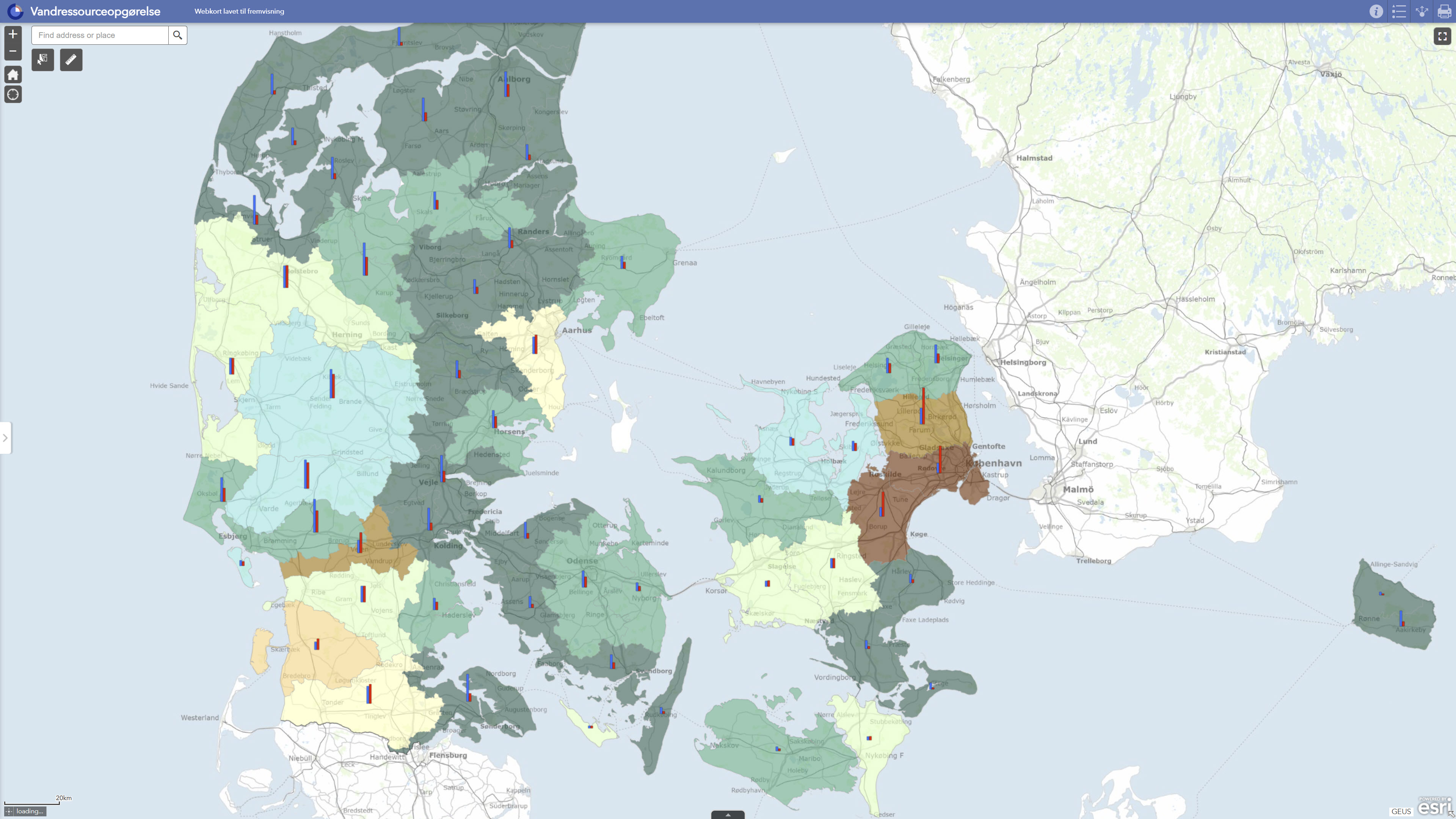
Interactive map displaying the dataset.
- OnLine resource
-
Report
(
DOI
)
Search for publications by GEUS researchers in GEUS' Publications
- OnLine resource
-
Data exhibition
(
WWW:LINK-1.0-http--link
)
GEUS displays data and results calculated with DK-model 2019 via GIS web portals. The data can be downloaded individually or together in GIS packages from Dataverse.
- OnLine resource
-
National Water Resource Model. Calculation of utilization rates, lowering and stream impact with DK model 2019
(
DOI
)
Henriksen, H. J., Voutchkova, D., Troldborg, L., Ondracek, M., Schullehner, J., & Hansen, B. (2019). National Water Resources Model. Calculation of utilization rates, lowering and watercourse impact with DK model 2019. GEUS. Geological Survey of Denmark and Greenland Report Vol. 2019 No. 32 https://doi.org/10.22008/gpub/32632
- OnLine resource
-
Vandressourceopgoerelse
(
ESRI:REST
)
ArcGIS REST Service
- OnLine resource
-
Grundvandsressource_(ALT)6560
(
OGC:WMS-1.3.0-http-get-capabilities
)
ArcGIS WMS Service
- Hierarchy level
- Dataset
- Statement
- The water resources assessment is derived from dynamic model calculations with DK model 2019, GEUS’ national hydrological model for Denmark. The model was updated with new groundwater bodies, new hydrogeological mapping information and a new calibration against observed groundwater heads and stream discharge. For each groundwater body, inflow and groundwater recharge were assessed on the basis of the hydrogeological model, including downward, upward and horizontal flow components. Water abstractions were incorporated for the individual groundwater bodies for the same calculation period. Exploitation rates were calculated as the ratio between total abstraction and total groundwater recharge for the period 2011–2017. The results were used for water balance testing and assessment of groundwater bodies where the exploitation rate under current abstraction conditions may indicate a risk of poor quantitative status. The assessment has subsequently been published as GIS layers and webGIS through GEUS’ data portal.
- File identifier
- 30d749e4-ce38-4a59-a4e8-c8e66f044f58 XML
- Metadata language
- Danskda
- Character set
- UTF8
- Hierarchy level
- Dataset
- Date stamp
- 2026-05-08T09:26:48.024925Z
- Metadata standard name
- ISO 19115:2003/19139
- Metadata standard version
- 1.0
Overviews
Spatial extent
Provided by
