 Arctic SDI catalogue
Trends and Extremes - Flood Susceptibility Mapping
This collection of flood susceptibility products captures temporal patterns of historic flood events from 2000 to 2023, derived from flood susceptibility maps. The layers are designed to support decision-making by providing easily interpretable information for planning, screening, and other management purposes.
This collection contains several datasets which explore the suite of rasters from 2000 to 2023:
- Extreme wet and extreme dry years and the associated average flood susceptibility, processed by NHN WU, as found by Generalized Extreme Value (GEV) analysis
- Flood susceptibility envelope, which is derived from the above wet and dry years
- Trend slope, for each pixel the value for each year is extracted and the linear trend is computed, greater than 1000 is increasing flood susceptibility and below 1000 is decreasing flood susceptibility.
- Trend Class, as identified by wet and dry scores, applied to NHN WU
- Current flood susceptibility, which represents the estimated average value of present-day flood susceptibility
- Current interquartile range, which provides and indication of the temporal variability of a given pixel under the current regime.
This dataset forms part of a broader collection of flood susceptibility datasets, offering related information and analyses. The collection includes an overview page with associated publications, historic susceptibility values, temporal trends, and future projections.
- **[Collection - Flood Susceptibility Mapping](https://open.canada.ca/data/en/dataset/1074f781-85d3-4c86-86cb-fd1c339197dc)**
- **[Historic - Flood Susceptibility Mapping](https://open.canada.ca/data/en/dataset/ea1384df-bf4a-4743-97bb-870dc43f8d77)**
- **[Future - Flood Susceptibility Mapping](https://open.canada.ca/data/en/dataset/c00f95a3-7bab-4d28-b9cc-b30f06b5afd2)**
Simple
- Date ( RI_367 )
- 2026-03
- Date ( RI_366 )
- 2026-03
- Purpose
-
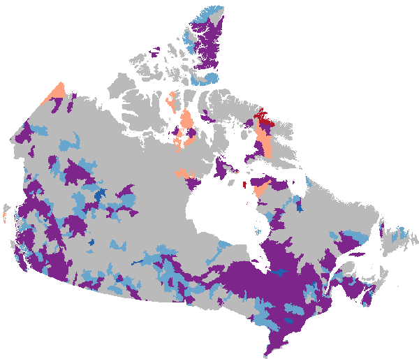
The following “decision-ready” products are derived from the full time series of flood susceptibility maps from 2000 to 2023. Each layer provides an easy-to-understand summary of long-term patterns, current conditions, or year-to-year variability.
- Extreme Wet and Dry Years (GEV Analysis): Identifies the years with unusually high and unusually low flood‑related conditions, along with the average flood susceptibility during those years. Helps users understand how extreme conditions shape long‑term patterns. Values range: 0 to 100
- Flood Susceptibility Envelope: Combines the extreme wet and extreme dry years to show the full range of possible flood susceptibility values for each location. Pixel Values: 0 = Non-flooded, 1 = Dry extreme years, 2 = Wet extreme years (higher probability of wet conditions), 3= Wet extreme years with low confidence
- Trend Slope (2000–2023): Examines each pixel over the full time span and calculates whether susceptibility is increasing or decreasing. Values above 1000 indicate increasing susceptibility and values below 1000 indicate decreasing susceptibility.
- Trend Class: Groups pixels into classes based on how consistently they show wet‑year or dry‑year behaviour over time. Helps highlight areas with clear long‑term patterns. Pixel values: 6=Strong Wetting, 5=Moderate Wetting, 4=Inconclusive, 3=Mixed Significant, 2=Moderate Drying, 1=Strong Drying, 255=NoData.
- Current Flood Susceptibility: Shows the estimated average conditions for the most recent period—useful for understanding how things look today. Values range: 0 to 100
- Current Interquartile Range (IQR): Measures how much flood susceptibility varies from year to year under current conditions. Higher values indicate locations with more variability. Coloured by range: 0 - 4 = Very stable, 5 - 9 = Light Interannual Variability, 5 - 9 = Moderate Interannual Variability, 10-19 = Strong Interannual Variability, 20-29 = Very Strong Interannual Variability, 30-52 = High instability
- Credit
- Canada Centre for Remote Sensing (CCRS)/Canada Centre for Mapping and Earth Observation (CCMEO), Natural Resources Canada (NRCan)
- Status
- onGoing; enContinue RI_596
- Maintenance and update frequency
- asNeeded; auBesoin RI_540
- Keywords ( RI_528 )
-
- flood susceptibility
- flood likelihood
- flood screening
- extremes
- trends
- Keywords ( RI_525 )
-
- Mid-latitude
- Western Hemisphere
- Northern Hemisphere
- North America
- Canada
- Government of Canada Core Subject Thesaurus Thésaurus des sujets de base du gouvernement du Canada ( RI_528 )
-
- Earth sciences
- Surface water
- Hydrology
- Floods
- Water management
- Use limitation
- Open Government Licence - Canada (http://open.canada.ca/en/open-government-licence-canada)
- Access constraints
- license; licence RI_606
- Use constraints
- license; licence RI_606
- Spatial representation type
- grid; grille RI_636
- Metadata language
- eng; CAN
- Character set
- utf8; utf8 RI_458
- Topic category
-
- Climatology, meteorology, atmosphere
- Environment
- Geoscientific information
- Inland waters
- Begin date
- 2000
- End date
- 2023
))
- Reference system identifier
- https://www.epsg-registry.org / EPSG:3979 /
- Distribution format
-
-
COG
(
Unknown
)
-
COG
(
Unknown
)
- OnLine resource
-
Scientific Publication
(
HTTPS
)
Supporting Document;HTML;eng
- OnLine resource
-
SpatioTemporal Asset Catalog (STAC) browser Application Programming Interface (API)
(
HTTPS
)
API;JSON;eng
- OnLine resource
-
SpatioTemporal Asset Catalog (STAC) browser
(
HTTPS
)
Application;HTML;zxx
- OnLine resource
-
Layers / Couches
(
OGC:WMS
)
Web Service;WMS;eng
- OnLine resource
-
Layers / Couches
(
OGC:WMS
)
Web Service;WMS;fra
- OnLine resource
-
Present day (FS 2000-2023 estimate)
(
HTTPS
)
Dataset;COG;zxx
- File identifier
- 3202e0a0-0afb-4120-b102-b0c41f0fb9eb XML
- Metadata language
- eng; CAN
- Character set
- utf8; utf8 RI_458
- Parent identifier
- Collection - Flood Susceptibility Mapping 1074f781-85d3-4c86-86cb-fd1c339197dc
- Hierarchy level
- dataset; jeuDonnées RI_622
- Date stamp
- 2026-05-07T11:41:11
- Metadata standard name
- North American Profile of ISO 19115:2003 - Geographic information - Metadata
- Metadata standard version
- CAN/CGSB-171.100-2009
Overviews
Spatial extent
Provided by
