 Arctic SDI catalogue
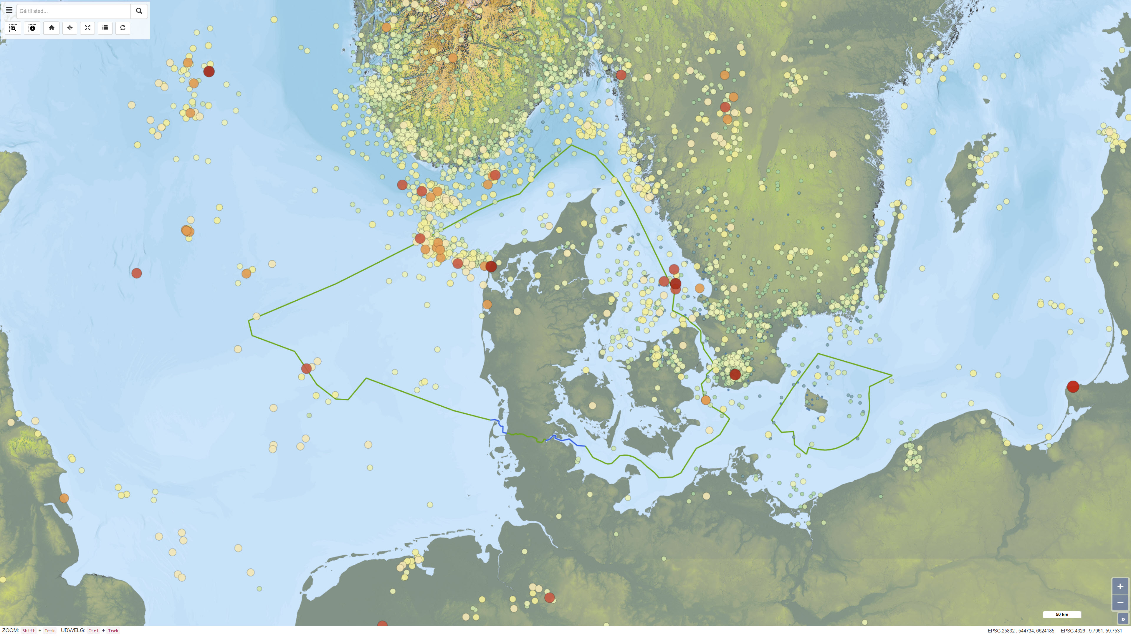
Recorded earthquakes in Denmark
Simple
- Date ( Publication )
- 2025-05-20
- Identifier
- dk.geus / earthquake_denmark
- Presentation form
- Digital map
- Purpose
- The purpose of this dataset is to support scientific analysis, regulatory advice and public information on seismic activity in Denmark. The dataset is used to map where and when tremors occur, to analyze their strength and depth, and for hazard assessments and planning related to buildings and infrastructure.
- Status
- On going
- Maintenance and update frequency
- As needed
- Keywords ( Theme )
-
- Dataset
- Seismology
- Earthquake
- Database
- Forskningsemner Forskningsemner ( Theme )
- Geografisk Geografisk ( Place )
- Access constraints
- Other restrictions
- Use constraints
- Other restrictions
- Other constraints
- CC BY 4.0
- Spatial representation type
- Vector
- Denominator
- 100000
- Metadata language
- Da
- Character set
- UTF8
- Topic category
-
- Geoscientific information
- Begin date
- 1930-10-31
))
- Supplemental Information
- The dataset is based on the GEUS earthquake database and is updated daily. Event times, locations and magnitudes may therefore change over time as new data are added and existing events are revised. Continuous quality control is carried out to identify and remove non-seismic events, such as explosions caused by military exercises or mine clearance. The dataset may therefore change over time, and some uncertainty is associated with the determination of epicentre and depth. Only confirmed and probable earthquakes are included.
- Reference system identifier
- ETRS 89 / UTM 32N (EPSG:25832)
- Distribution format
-
-
GeoJSON
(
)
-
WFS
(
)
-
WMS
(
)
-
SHP
(
)
-
GeoJSON
(
)
- OnLine resource
-
GEUS earthquake database
GeoJSON for GEUS earthquake database. Data is extracted automatically and quality assured continuously, where other detections are removed e.g. explosions from the military defense. Information such as time, position and size may therefore change. Earthquakes and detections in our neighboring countries are not reviewed by GEUS.
- OnLine resource
-
Earthquakes and seismology
(
WWW:LINK-1.0-http--link
)
GEUS is responsible for monitoring and registration of earthquakes and other seismic activities in Denmark and Greenland.
- OnLine resource
-
Interactive webmap
(
WWW:LINK-1.0-http--link
)
GEUS' Earthquake portal contains all registered earthquakes across Denmark, extracted from GEUS' earthquake database.
- OnLine resource
-
earthquakes_denmark
(
OGC:WMS-1.3.0-http-get-capabilities
)
WMS for Earthquakes Denmark
- OnLine resource
-
ms:earthquakes_denmark
(
OGC:WFS-1.0.0-http-get-capabilities
)
WFS for Earthquakes Denmark
- OnLine resource
-
Download
Download dataset as shapefile
- Hierarchy level
- Dataset
- Statement
- The dataset is based on observations from GEUS’ national seismic network and associated seismographs that continuously record seismic activity in Denmark and surrounding areas. The recordings are automatically collected in the GEUS earthquake database and subsequently subjected to both automated and manual quality control performed by seismologists. As part of the quality-assurance process, non-seismic events, including explosions caused by military activities or other anthropogenic sources, are identified and removed. The dataset represents an ongoing interpretation of seismic measurements and reflects the data basis, instrumentation and analysis methods applied at the time of registration.
- File identifier
- 38176720-bb29-4e8d-889c-eddad17a0545 XML
- Metadata language
- Danskda
- Character set
- UTF8
- Hierarchy level
- Dataset
- Date stamp
- 2026-03-02T08:06:09.799108Z
- Metadata standard name
- ISO 19115:2003/19139
- Metadata standard version
- 1.0
Overviews
Spatial extent
Provided by
