 Arctic SDI catalogue
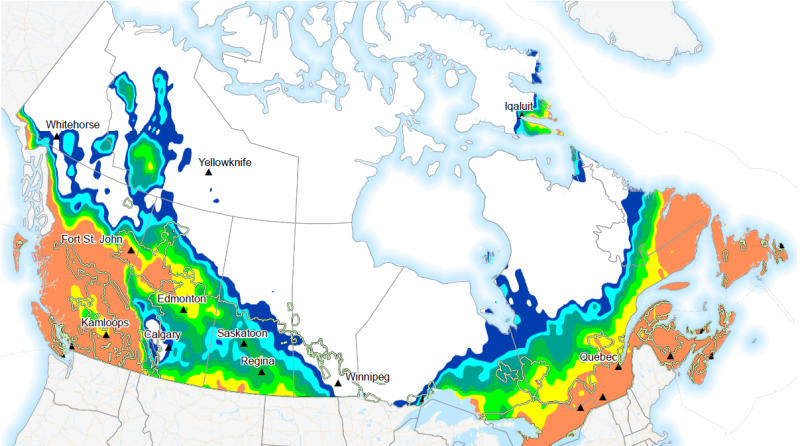
Probability of 10-day precipitation above 10mm
Probability of 10-day precipitation total above 10mm (p10d_prob10).
Week 1 and week 2 forecasted probability is available daily from September 1 to August 31.
Week 3 and week 4 forecasted probability is available weekly (Thursday) from September 1 to August 31.
Precipitation (moisture availability) establishes the economic yield potential and product quality of field crops. Both dry and wet precipitation extremes have the ability to inhibit proper crop growth. The greatest daily precipitation index covers the risk of excessive precipitation in the short term, while the other indices pertain to longer term moisture availability.
Agriculture and Agri-Food Canada (AAFC) and Environment and Climate Change Canada (ECCC) have together developed a suite of extreme agrometeorological indices based on four main categories of weather factors: temperature, precipitation, heat, and wind. The extreme weather indices are intended as short-term prediction tools and generated using ECCC’s medium range forecasts to create a weekly index product on a daily and weekly basis.
Simple
- Date ( RI_367 )
- 2019-01-31
- Date ( RI_366 )
- 2018-11-01
- Status
- onGoing; enContinue RI_596
- Maintenance and update frequency
- daily; quotidien RI_533
- Keywords ( RI_529 )
-
- Extreme Weather Indices
- Government of Canada Core Subject Thesaurus Thésaurus des sujets de base du gouvernement du Canada ( RI_528 )
-
- Farmlands
- Weather
- Weather forecasts
- Agriculture
- Climate
- Meteorology
- Precipitation
- Use limitation
- Open Government Licence - Canada (http://open.canada.ca/en/open-government-licence-canada)
- Access constraints
- license; licence RI_606
- Use constraints
- license; licence RI_606
- Spatial representation type
- grid; grille RI_636
- Metadata language
- eng; CAN
- Topic category
-
- Climatology, meteorology, atmosphere
- Begin date
- 2018-11-01
))
- Reference system identifier
- http://www.epsg.org/ / EPSG:3857 / 8.3.4
- Distribution format
-
-
GeoTIF
(
6.0
)
-
GeoTIF
(
6.0
)
- OnLine resource
-
Data Product Specification (French)
(
HTTPS
)
Supporting Document;PDF;fra
- OnLine resource
-
Data Product Specification (English)
(
HTTPS
)
Supporting Document;PDF;eng
- OnLine resource
-
Pre-packaged GeoTIF files (No linguistic component)
(
HTTPS
)
Dataset;GeoTIF;zxx
- OnLine resource
-
Pre-packaged Maps (English)
(
HTTPS
)
Supporting Document;PDF;eng
- OnLine resource
-
Pre-packaged Maps (French)
(
HTTPS
)
Supporting Document;PDF;fra
- File identifier
- 385255f7-3218-4f31-9121-7143b8d0d236 XML
- Metadata language
- eng; CAN
- Character set
- utf8; utf8 RI_458
- Parent identifier
- Extreme Weather Indices: Precipitation 0a2e22a2-a7a1-47d4-9249-3eaafe1c815b
- Hierarchy level
- dataset; jeuDonnées RI_622
- Date stamp
- 2023-01-03T11:05:07
- Metadata standard name
- North American Profile of ISO 19115:2003 - Geographic information - Metadata
- Metadata standard version
- CAN/CGSB-171.100-2009
Overviews

Spatial extent
Provided by
