 Arctic SDI catalogue
Coastal Infrastructure Vulnerability Index 2.0
The Coastal Infrastructure Vulnerability Index (CIVI) was developed by Fisheries and Oceans Canada (DFO) to provide a standardized, evidence‑based approach for assessing the relative vulnerability of Small Craft Harbours (SCH) infrastructure to climate change. Building on the first‑generation CIVI released in 2018, this report presents the second‑generation framework, CIVI 2.0, which incorporates updated climate projections and additional engineering information. CIVI 2.0 adopts the widely used vulnerability framework of sensitivity, exposure, and adaptive capacity, enabling greater alignment with current climate‑risk science and enhancing interpretability for decision‑makers.
The methodology integrates national datasets on coastal geomorphology, relative sea‑level change, ice‑climate projections, harbour condition, facility protection, replacement cost, harbour utilization, and geographic proximity. Indicators are normalized and combined using a geometric‑mean approach to reduce the influence of outliers while preserving regional variability. CIVI 2.0 also incorporates new contextual information—including fishery‑reliant communities, Indigenous communities, commercial landings, and species‑level climate‑risk estimates—to support more holistic decision‑making, while maintaining a strictly indicator‑based index for vulnerability scoring.
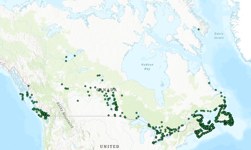
Results highlight substantial regional variation in infrastructure vulnerability across Canada. Marine sites in the Gulf of St. Lawrence generally exhibit high exposure due to projected increases in relative sea level and reductions in ice days, whereas many British Columbia and inland sites exhibit lower overall vulnerability. The updated framework improves national consistency, enhances transparency, and provides a reproducible methodology to support adaptive planning and prioritization under changing climate conditions.
CIVI 2.0 is intended as an operational tool for SCH program managers, engineers, and policy analysts, guiding capital planning, risk reduction, and long‑term climate‑resilience strategies across Canada’s fishing harbour network.
Cite this data as: Greenan, B., Shackell, N., Daigle, R., Harbin, J., Ferguson, K., Brickman, D., Boyce, D. Coastal Infrastructure Vulnerability Index 2.0.
Published August 2026. Ocean Ecosystem Science Division, Fisheries and Oceans Canada, Dartmouth, N.S. https://open.canada.ca/data/en/dataset/38923004-919c-4446-9824-fb99fd1a4368
Simple
- Date ( RI_367 )
- 2026-08-06
- Date ( RI_366 )
- 2018-01-01
- Status
- completed; complété RI_593
- Maintenance and update frequency
- notPlanned; nonPlanifié RI_542
- Keywords
-
- climate change adaptation
- coastal infrastructure
- Government of Canada Core Subject Thesaurus Thésaurus des sujets de base du gouvernement du Canada ( RI_528 )
-
- Oceans
- Use limitation
- Open Government Licence - Canada (http://open.canada.ca/en/open-government-licence-canada)
- Access constraints
- license; licence RI_606
- Use constraints
- license; licence RI_606
- Classification
- unclassified; nonClassifié RI_484
- Spatial representation type
- vector; vecteur RI_635
- Metadata language
- eng; CAN
- Character set
- utf8; utf8 RI_458
- Topic category
-
- Oceans
- Begin date
- 2000-01-01
- End date
- 2100-12-31
))
- Reference system identifier
- https://epsg.io / EPSG:4326 / 8.2.6
- Distribution format
-
-
ESRI REST
(
2.9.8
)
-
CSV
(
N/A
)
-
FGDB/GDB
(
2.9.8
)
-
ESRI REST
(
2.9.8
)
- OnLine resource
-
Coastal Infrastructure Vulnerability Index 2.0
(
HTTPS
)
Dataset;FGDB/GDB;eng,fra
- OnLine resource
-
Data Dictionary
(
HTTPS
)
Supporting Document;CSV;eng,fra
- OnLine resource
-
Coastal Infrastructure Vulnerability Index 2.0
(
HTTPS
)
Dataset;CSV;eng,fra
- OnLine resource
-
Technical Report
(
HTTPS
)
Supporting Document;PDF;eng,fra
- OnLine resource
-
Coastal Infrastructure Vulnerability Index 2.0
(
ESRI REST: Map Service
)
Web Service;ESRI REST;eng
- OnLine resource
-
Coastal Infrastructure Vulnerability Index 2.0
(
ESRI REST: Map Service
)
Web Service;ESRI REST;fra
- File identifier
- 38923004-919c-4446-9824-fb99fd1a4368 XML
- Metadata language
- eng; CAN
- Character set
- utf8; utf8 RI_458
- Hierarchy level
- dataset; jeuDonnées RI_622
- Date stamp
- 2026-08-07T15:35:30.169735Z
- Metadata standard name
- North American Profile of ISO 19115:2003 - Geographic information - Metadata
- Metadata standard version
- CAN/CGSB-171.100-2009
Overviews
Spatial extent
Provided by
