 Arctic SDI catalogue
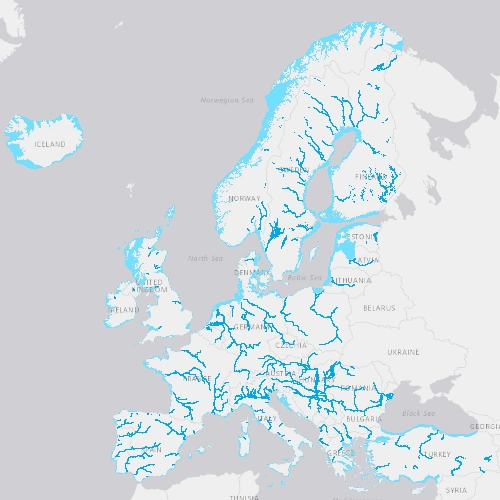
EU-Hydro River Network Database 2006-2012 (vector), Europe - version 1.3, Nov. 2020
EU-Hydro is a dataset for all EEA38 countries and the United Kingdom providing photo-interpreted river network, consistent of surface interpretation of water bodies (lakes and wide rivers), and a drainage model (also called Drainage Network), derived from EU-DEM, with catchments and drainage lines and nodes.
The EU-Hydro dataset is distributed in separate files (river network and drainage network) for each of the 35 major basins of the EEA38 + UK area, in GDB and GPKG formats.
The production of EU-Hydro and the derived layers was coordinated by the European Environment Agency in the frame of the EU Copernicus programme.
Simple
- Date ( Creation )
- 2019-11-19
- Date ( Publication )
- 2019-11-19
- Date ( Revision )
- 2020-11-25
- Edition
- 01.03
- Identifier
- copernicus_v_3035_50_k_hydro-rn_p_2006-2012_v01_r03
- Identifier
- DAT-194-en
- Unique resource identifier
- 10.2909/393359a7-7ebd-4a52-80ac-1a18d5f3db9c
- Maintenance and update frequency
- Continual
- GEMET - INSPIRE themes, version 1.0 ( Theme )
-
- Hydrography
- Land cover
- Keywords
-
- Continents, countries, sea regions of the world. ( Place )
-
- United Kingdom
- EEA38 (from 2020)
- Keywords
-
- GEMET ( Theme )
-
- river
- environment
- ocean
- catchment area
- land
- hydrographic network
- drainage system
- hydrology
- landscape alteration
- inland water
- canal
- drainage
- catchment
- water body
- Spatial scope ( Theme )
- EEA topics ( Theme )
-
- Land use
- EEA Management Plan ( Theme )
-
- 2017 3.6.1
- Access constraints
- Other restrictions
- Other constraints
- no limitations to public access
- Use constraints
- Other restrictions
- Other constraints
-
The Copernicus component is governed by Regulation (EU) No 2021/696 of the European Parliament and of the Council of 28 April 2021 establishing the Union Space Programme and the European Union Agency for the Space Programme and repealing Regulations (EU) No 912/2010, (EU) No 1285/2013 and (EU) No 377/2014 and Decision No 541/2014/EU. Within the Copernicus component, a portfolio of land monitoring activities has been delegated by the European Union to the European Environment Agency (EEA) and the DG Joint Research Centre of the European Commission.
The Copernicus land monitoring products and services are made available on a principle of full, open and free access, as established by the Commission Delegated Regulation (EU) No 1159/2013 of 12 July 2013.
Free, full and open access to the products and services of the Copernicus Land Monitoring Service is made on the conditions that:
1. When distributing or communicating Copernicus Land Monitoring Service products and services (data, software scripts, web services, user and methodological documentation and similar) to the public, users shall inform the public of the source of these products and services.
2. Where the Copernicus Land Monitoring Service products and services have been adapted or modified by the user, the user shall clearly state this.
3. Users shall make sure not to convey the impression to the public that the user's activities are officially endorsed by the European Union.
- Aggregate Datasetindentifier
- a4613aeb-ec3e-49c5-adca-69cd1c9204a3
- Association Type
- revisionOf
- Spatial representation type
- vector Vector
- Denominator
- 50000
- Metadata language
- en
- Character set
- utf8 UTF8
- Topic category
-
- Environment
- Imagery base maps earth cover
- Begin date
- 2006-01-01
- End date
- 2012-12-31
))
))
))
))
))
- Supplemental Information
- Spatial Resolution information: Minimum Mapping Unit (MMU): 1 ha
- Unique resource identifier
- EPSG:3035
- Distribution format
-
-
GDB
(
9.3
)
-
Geopackage
(
)
-
GDB
(
9.3
)
- OnLine resource
- https://doi.org/10.2909/393359a7-7ebd-4a52-80ac-1a18d5f3db9c ( DOI )
- OnLine resource
- EU-Hydro - River Network Database ( OGC:WMS )
- OnLine resource
- Product Information & Technical Documentation ( WWW:LINK )
- OnLine resource
- https://image.discomap.eea.europa.eu/arcgis/rest/services/EUHydro/EUHydro_RiverNetworkDatabase/MapServer ( ESRI:REST )
- OnLine resource
-
CLMS Website
(
WWW:DOWNLOAD
)
Download (requires authentication)
- Hierarchy level
- Dataset
Conformance result
- Date ( Publication )
- 2010-12-08
- Explanation
- See the referenced specification
- Statement
- Space imagery SP05 (resolution 2.5 m) and SP06 (resolution 2.5 m), space imagery IMAGE2009 (resolution 20 m), EEA member countries WFD reporting data on water bodies: for Türkiye (EEA member), Albania, Bosnia-Herzegovina, North Macedonia, Montenegro, Kosovo (UNSCR 1244/99) and Serbia (all EEA cooperating countries) no spatial data for any category of water bodies was available, European Catchments and Rivers Network System (ECRINS); ancillary data: European Lakes and Reservoirs database (Eldred), Russian topographic maps. The upgrade of the EU-Hydro beta version includes improvements of the usability of the dataset, of its topological and logical consistency and the River network characteristics. Catchments layers were also modified to fit the River networks. Topological overlapping and gaps between River Basin Districts were corrected. The EU-Hydro V1.1 upgrade includes the reclassification of polygons between InlandWater, Coastal-p, Transit_p and River_Net_p classes, the upgrade of the WFD codes using the WISE geospatial dataset for these feature classes, the improvement of logical consistency of attribute tables (deletion of irrelevant fields, recalculation of OBJECT_ID field, recalculation of geometry properties field). In Version 1.2 the Drainage network derived from EUDEM was incorporated to the river network of EU hydro: four feature classes were generated: River_Net_l_DN, Canals_l_DN, Ditches_l_DN and Nodes_DN. River names were updated using WISE geospatial database, except for Thames, Tweed and Türkiye where ECRINS was used instead. In version 1.3, 'River_Net_l' topology was adjusted to fit Coastal_p and Transit_p: polylines were deleted for Gota, Skjern, Shannon, Tweed. Polylines were added in Skjern, Mesima and Tajo on areas overlapping Transit_p. Nodes were modified accordingly. CUM_LEN, LONGPATH, LENGTH GEO fields were recalculated.
- File identifier
- 393359a7-7ebd-4a52-80ac-1a18d5f3db9c XML
- Metadata language
- en
- Character set
- UTF8
- Hierarchy level
- Dataset
- Date stamp
- 2025-10-09T10:45:20.507499Z
- Metadata standard name
- ISO 19115/19139
- Metadata standard version
- 1.0
Overviews
Spatial extent
Provided by
