 Arctic SDI catalogue
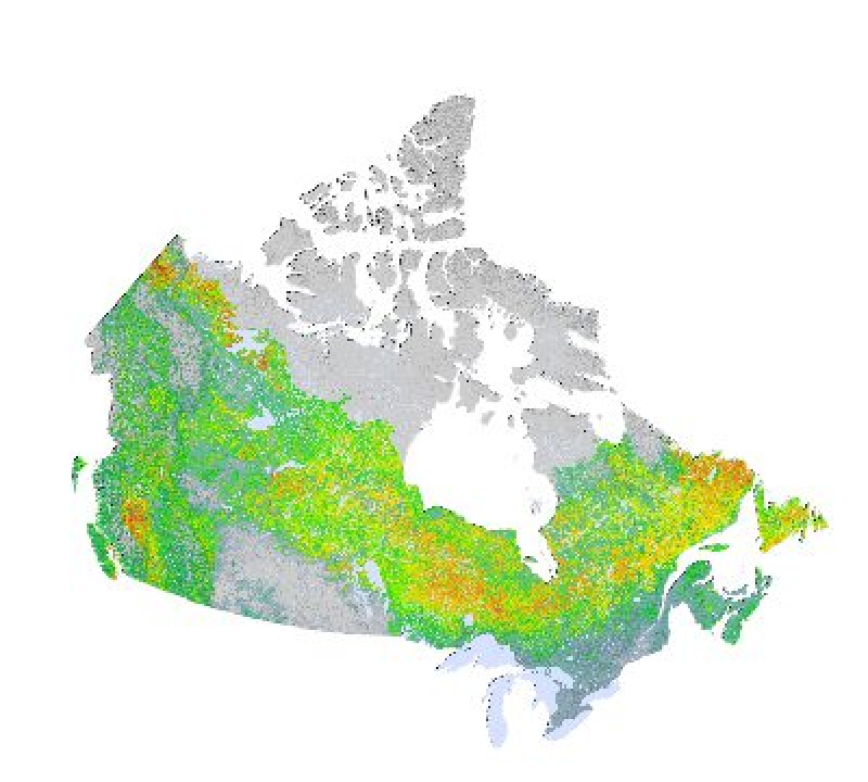
Needle-leaved species in Canada 2006
Canada's National Forest Inventory (NFI) sampling program is designed to support reporting on forests at the national scale. On the other hand, continuous maps of forest attributes are required to support strategic analyses of regional policy and management issues. We have therefore produced maps covering 4.03 × 10⁶ km2 of inventoried forest area for the 2001 base year using standardised observations from the NFI photo plots (PP) as reference data. We used the k nearest neighbours (kNN) method with 26 geospatial data layers including MODIS spectral data and climatic and topographic variables to produce maps of 127 forest attributes at a 250 × 250 m resolution. The stand-level attributes include land cover, structure, and tree species relative abundance. In this article, we report only on total live aboveground tree biomass, with all other attributes covered in the supplementary data (http://nrcresearchpress.com/doi/suppl/10.1139/cjfr-2013-0401). In general, deviations in predicted pixel-level values from those in a PP validation set are greater in mountainous regions and in areas with either low biomass or sparse PP sampling. Predicted pixel-level values are overestimated at small observed values and underestimated at large ones. Accuracy measures are improved through the spatial aggregation of pixels to 1 km2 and beyond. Overall, these new products provide unique baseline information for strategic-level analyses of forests (https://nfi.nfis.org)
Collection:
- **[Canada's National Forest Inventory (NFI) 2006](https://open.canada.ca/data/en/dataset/e2fadaeb-3106-4111-9d1c-f9791d83fbf4)**
Simple
- Date ( RI_367 )
- 2016-05-13
- Date ( RI_366 )
- 2016
1-418-648-5849
https://www.rncan.gc.ca/science-et-donnees/centres-de-recherche-et-laboratoires/centre-recherche-forets/centre-foresterie-laurentides/13474
- Status
- completed; complété RI_593
- Maintenance and update frequency
- asNeeded; auBesoin RI_540
- Government of Canada Core Subject Thesaurus Thésaurus des sujets de base du gouvernement du Canada ( RI_528 )
-
- Forests
- Forestry
- Use limitation
- Open Government Licence - Canada (http://open.canada.ca/en/open-government-licence-canada)
- Access constraints
- licenseUnrestricted; licenceSansRestriction RI_610
- Use constraints
- otherRestrictions; autresRestrictions RI_609
- Other constraints
-
How can this data be used?
The resolution and accuracy of these map products are best suited for strategic-level forest reporting and informing policy and decision making at regional to national scales. As these maps also offer a coherent set of quantitative values for a large suite of forest attributes, they can be used as baseline information for modelling and in calculations such as merchantable forest volume or percentage of tree species. It is also possible to overlay these maps with other maps produced on the same pixel grid to make assessments of disturbance impacts, such as fire and harvests.
- Spatial representation type
- grid; grille RI_636
- Metadata language
- eng
- Character set
- utf8; utf8 RI_458
- Topic category
-
- Environment
- Begin date
- 2001
- End date
- 2006
))
- Reference system identifier
- http://www.epsg-registry.org / EPSG:3978 /
- Distribution format
-
-
GeoTIF
(
1
)
-
GeoTIF
(
1
)
https://nfi.nfis.org
- Hours of service
- 08:00 - 16:00
- OnLine resource
-
TAR packages at tree.pfc.forestry.ca
(
HTTP
)
Dataset;GeoTIF;eng
- OnLine resource
-
Mapping attributes of Canada’s forests at moderate resolution through kNN and MODIS imagery
(
HTTPS
)
Supporting Document;HTML;eng
- OnLine resource
-
Needle-leaved species in Canada
(
OGC:WMS
)
Web Service;WMS;eng
- OnLine resource
-
Needle-leaved species in Canada
(
OGC:WMS
)
Web Service;WMS;fra
- OnLine resource
-
Canada's National Forest Inventory (NFI) (English)
(
HTTPS
)
Application;HTML;eng
- OnLine resource
-
Canada's National Forest Inventory (NFI) (French)
(
HTTPS
)
Application;HTML;fra
- File identifier
- 39ffee48-f89b-4b65-af03-58a706bac7a1 XML
- Metadata language
- eng; CAN
- Character set
- utf8; utf8 RI_458
- Parent identifier
- Canada's National Forest Inventory (NFI) 2006 e2fadaeb-3106-4111-9d1c-f9791d83fbf4
- Hierarchy level
- dataset; jeuDonnées RI_622
- Date stamp
- 2021-05-20T17:56:40
- Metadata standard name
- North American Profile of ISO 19115:2003 - Geographic information - Metadata
- Metadata standard version
- CAN/CGSB-171.100-2009
http://nfis.org
Overviews


Spatial extent
Provided by
