 Arctic SDI catalogue
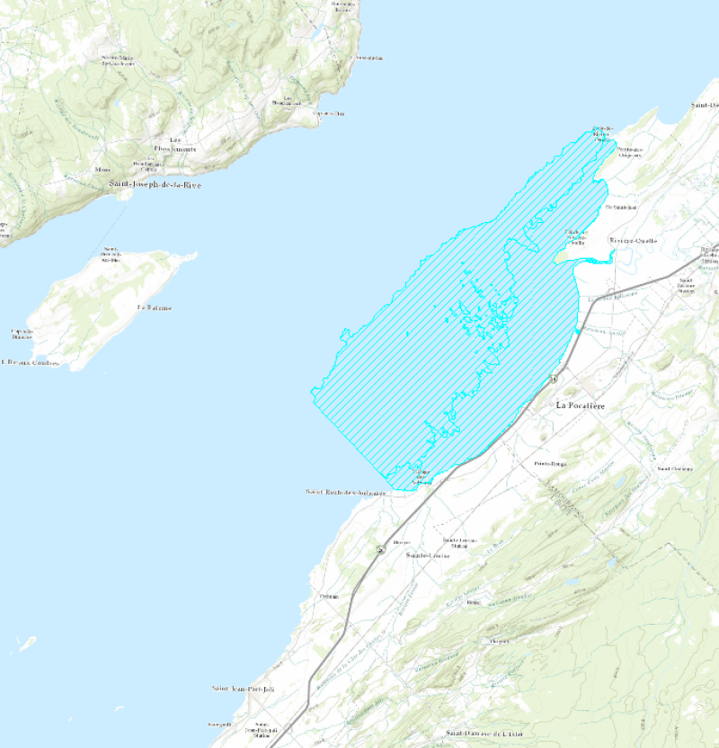
Critical habitat of the St. Lawrence estuary population of Striped Bass
Striped Bass critical habitat (St. Lawrence estuary population) defined by the analysis of available knowledge in 2011 and a scientific advice.
Purpose
The status of the Striped Bass population of the St. Lawrence Estuary is in constant evolution. It went from indigenous population until the end of 1960 to designated extirpated in Canada under the Species at Risk Act (SARA) in 2011.
Still in 2011, the status of the population of the St. Lawrence Estuary was reassessed by the Committee on the Status of Endangered Wildlife in Canada (COSEWIC) following the Ministère des Ressources naturelles et de la Faune du Québec re-introduction efforts and was designated endangered (COSEWIC 2012). Under SARA, critical habitat must be designated for all threatened, endangered or extirpated species.
Additional Information
The analysis of available knowledge on habitat quality assessment and its use by the Striped Bass was realized using two research documents: Pelletier et al. (2010) and Robitaille (2010). These documents were then reviewed during a scientific peer review meeting in April 2010. A Recovery Strategy was also established in 2011.
Pelletier, A.-M., G. Verrault, G. Bourget and J. Dussureault. 2010. Utilisation de l’habitat par les différents stades de développement de la population réintroduite de bars rayés (Morone saxatilis) de l’estuaire du Saint-Laurent. Ministère des Ressources naturelles et de la Faune du Québec, Direction de l’Expertise Faune-Forêt-Territoire du Bas-Saint-Laurent. 50 p.
Robitaille, J. 2010. Assessment of Habitat Quality and Habitat Use by the Extirped Striped Bass Population (Morone saxatilis) of St. Lawrence Estuary, Quebec DFO Canadian Science Advisory Secretariat. Research Document. 2010/052. 22 p.
DFO. 2011. Assessment of Habitat Quality and Habitat Use by the Striped Bass (Morone saxatilis) Population of the St. Lawrence Estuary, Quebec. DFO Can. Sci. Advis. Sec. Sci. Advis. Rep. 2010/069.
DFO. 2011. Robitaille, J., M. Bérubé, A. Gosselin, M. Baril, J. Beauchamp, J. Boucher, S. Dionne, M. Legault, Y. Mailhot, B. Ouellet, P. Sirois, S. Tremblay G. Trencia, G. Verreault and D. Villeneuve. 2011. Recovery Strategy for the Striped Bass (Morone saxatilis), St. Lawrence Estuary Population, Canada. Species at Risk Act Recovery Strategy Series. Ottawa : Fisheries and Oceans Canada. xi + 51 p.
The available information on habitat used and frequented by the St. Lawrence Estuary striped bass population has been reviewed later than 2011 and can be consulted at:
https://open.canada.ca/data/en/dataset/db177a8c-5d7d-49eb-8290-31e6a45d786c
Simple
- Date ( RI_366 )
- 2011
- Date ( RI_367 )
- 2011
- Status
- completed; complété RI_593
- Maintenance and update frequency
- asNeeded; auBesoin RI_540
- Keywords ( RI_530 )
-
- Critical Habitat
- Striped Bass
- Morone saxatilis
- Keywords ( RI_525 )
-
- St. Lawrence Estuary
- La Pocatière
- Rivière-Ouelle
- Government of Canada Core Subject Thesaurus Thésaurus des sujets de base du gouvernement du Canada ( RI_528 )
-
- Earth sciences
- Aquatic wildlife
- Marine biology
- Fish
- Classification
- unclassified; nonClassifié RI_484
- Use limitation
- Open Government Licence - Canada (http://open.canada.ca/en/open-government-licence-canada)
- Access constraints
- license; licence RI_606
- Use constraints
- license; licence RI_606
- Spatial representation type
- vector; vecteur RI_635
- Metadata language
- fra; CAN
- Character set
- utf8; utf8 RI_458
- Topic category
-
- Biota
- Environment
- Begin date
- 1943
- End date
- 2009
))
- Reference system identifier
- EPSG / EPSG:4617 / 7.4.1
- Distribution format
-
-
ESRI REST
(
10.3.1
)
-
ESRI REST
(
10.3.1
)
- OnLine resource
-
Critical Habitat of Species at Risk
(
HTTPS
)
Supporting Document;HTML;fra
- OnLine resource
-
Critical Habitat of Species at Risk
(
HTTPS
)
Supporting Document;HTML;eng
- OnLine resource
-
Striped bass essential habitat
(
HTTPS
)
Dataset;SHP;eng,fra
- OnLine resource
-
Striped bass essential habitat
(
ESRI REST: Map Service
)
Web Service;ESRI REST;eng
- OnLine resource
-
Striped bass essential habitat
(
ESRI REST: Map Service
)
Web Service;ESRI REST;fra
- File identifier
- 3a389738-dbc7-418b-af79-bcb05f61b576 XML
- Metadata language
- fra; CAN
- Character set
- utf8; utf8 RI_458
- Parent identifier
- Significant parameters for different species with status under the Species at Risk Act (SARA) 4c7880ac-cb01-4e12-8305-2ae8eb675390
- Hierarchy level
- dataset; jeuDonnées RI_622
- Date stamp
- 2025-02-06T12:39:26.771Z
- Metadata standard name
- North American Profile of ISO 19115:2003 - Geographic information - Metadata
- Metadata standard version
- CAN/CGSB-171.100-2009
Overviews
Spatial extent
Provided by
