 Arctic SDI catalogue
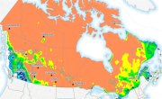
Probability of frost for warm season crops ( <0°C)
The Probability (likelihood) of frost occurring. The number of days in the forecast period with a minimum temperature below the frost temperature, the temperature at which frost damage occurs. This temperature is 0°C for warm season crops (ffd_warm_prob).
Week 1 and week 2 forecasted probability is available daily from April 1 to October 31.
Week 3 and week 4 forecasted probability is available weekly (Thursday) from April 1 to October 31.
Warm season crops require a relatively warm temperature condition. Typical examples include bean, soybean, corn and sweet potato. They normally grow during the summer season and early fall, then ripen in late fall in southern Canada only. Other agricultural regions in Canada do not always experience sufficiently long growing seasons for these plants to achieve maturity. The optimum temperature for such crops is 30°C.
Agriculture and Agri-Food Canada (AAFC) and Environment and Climate Change Canada (ECCC) have together developed a suite of extreme agrometeorological indices based on four main categories of weather factors: temperature, precipitation, heat, and wind. The extreme weather indices are intended as short-term prediction tools and generated using ECCC’s medium range forecasts to create a weekly index product on a daily and weekly basis.
Simple
- Date ( RI_367 )
- 2018-11-01
- Date ( RI_366 )
- 2018-11-01
- Status
- onGoing; enContinue RI_596
- Maintenance and update frequency
- daily; quotidien RI_533
- Keywords ( RI_529 )
-
- Extreme Weather Indices
- Government of Canada Core Subject Thesaurus Thésaurus des sujets de base du gouvernement du Canada ( RI_528 )
-
- Weather forecasts
- Climate
- Weather
- Meteorology
- Agriculture
- Temperature
- Farmlands
- Use limitation
- Open Government Licence - Canada (http://open.canada.ca/en/open-government-licence-canada)
- Access constraints
- license; licence RI_606
- Use constraints
- license; licence RI_606
- Spatial representation type
- grid; grille RI_636
- Metadata language
- eng; CAN
- Topic category
-
- Climatology, meteorology, atmosphere
- Begin date
- 2018-11-01
))
- Reference system identifier
- http://www.epsg.org/ / EPSG:3857 / 8.3.4
- Distribution format
-
-
GeoTIF
(
6.0
)
-
GeoTIF
(
6.0
)
- OnLine resource
-
Data Product Specification (French)
(
HTTPS
)
Supporting Document;PDF;fra
- OnLine resource
-
Data Product Specification (English)
(
HTTPS
)
Supporting Document;PDF;eng
- OnLine resource
-
Pre-packaged GeoTIF files (No linguistic component)
(
HTTPS
)
Dataset;GeoTIF;zxx
- OnLine resource
-
Pre-packaged Maps (English)
(
HTTPS
)
Supporting Document;PDF;eng
- OnLine resource
-
Pre-packaged Maps (French)
(
HTTPS
)
Supporting Document;PDF;fra
- File identifier
- 3f210c61-103c-4668-ad3f-b4949d15b032 XML
- Metadata language
- eng; CAN
- Character set
- utf8; utf8 RI_458
- Parent identifier
- Extreme Weather Indices: Temperature b7e2321b-056d-4121-b3b5-556c6b85d9a6
- Hierarchy level
- dataset; jeuDonnées RI_622
- Date stamp
- 2023-01-03T14:41:53
- Metadata standard name
- North American Profile of ISO 19115:2003 - Geographic information - Metadata
- Metadata standard version
- CAN/CGSB-171.100-2009
Overviews

Spatial extent
Provided by
