 Arctic SDI catalogue
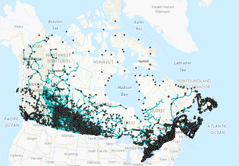
The Canadian Ecumene (CanEcumene) 3.0 GIS Database
“Ecumene” is a term used by geographers, meaning “inhabited lands.” Populated places in the ecumene database are referenced using natural boundaries, as opposed to administrative or census boundaries, and provide a more suitable means for integrating socio-economic data with ecological and environmental data in a region.
The Canadian Ecumene GeoDatabase 3.0 includes the custom boundaries for more than 3,000 populated areas across Canada, many of which were derived from remote-sensing “night-lights” imagery. Each ecumene place has a corresponding set of attributes pertaining to place name, province, ecozone, indigenous communities, and other descriptive information, as well as an initial custom set of demographic variables derived from Statistics Canada Census and National Household Survey data for 2001, 2006, 2011 and 2016. A number of additional layers are also included that map the extents of Canada's ecumene in alternate ways, using transportation and utility networks, nightlights imagery, and population density.
(NOTE: In the list below, the V2 Shape, KML, and TIFF files have not changed for the CanEcumene 3.0)
Provided layer: The Canadian Ecumene (CanEcumene) 3.0 GIS Database
============================================================================================
Database Citation (Update):
Eddy, B.G., Muggridge, M., LeBlanc, R., Osmond, J., Kean, C., and Boyd, E. 2023. The CanEcumene 3.0 GIS Database. Federal Geospatial Platform (FGP), Natural Resources Canada. https://open.canada.ca
Methods Publication Citation:
Eddy B, Muggridge M, LeBlanc R, Osmond J, Kean C, Boyd E (2020) An Ecological Approach for Mapping Socio-Economic Data in Support of Ecosystems Analysis: Examples in Mapping Canada’s Forest Ecumene. One Ecosystem 5: e55881. https://doi.org/10.3897/oneeco.5.e55881
Simple
- Date ( RI_367 )
- 2020
- Date ( RI_366 )
- 2016
- Status
- onGoing; enContinue RI_596
- Maintenance and update frequency
- asNeeded; auBesoin RI_540
- Keywords ( RI_525 )
-
- ecumene, populated places, indigenous communities, census, labour force, socio-economic, demographic, ecosystems
- Government of Canada Core Subject Thesaurus Thésaurus des sujets de base du gouvernement du Canada ( RI_528 )
-
- Socioeconomic data
- Ecosystems
- Census data
- Demographic maps
- Population
- Demographic data
- Population distribution
- Indigenous peoples
- Use limitation
- Open Government Licence - Canada (http://open.canada.ca/en/open-government-licence-canada)
- Access constraints
- license; licence RI_606
- Use constraints
- license; licence RI_606
- Spatial representation type
- vector; vecteur RI_635
- Metadata language
- eng
- Metadata language
- fra
- Topic category
-
- Environment
- Begin date
- 2001
- End date
- 2021
))
- Reference system identifier
- http://www.epsg-registry.org / EPSG:3978 /
- Reference system identifier
- http://www.epsg-registry.org / EPSG:3347 /
- Distribution format
-
-
SHP
(
unknown
)
-
ESRI REST
(
10.3.1
)
-
KML
(
unknown
)
-
FGDB/GDB
(
10.3.1
)
-
SHP
(
unknown
)
- OnLine resource
-
06. CanEcumene-V3 - Shape Files (SHP)
(
HTTPS
)
Dataset;SHP;eng,fra
- OnLine resource
-
10. CanEcumene-V3 - WMS - EN
(
HTTPS
)
Web Service;WMS;eng
- OnLine resource
-
11. CanEcumene-V3 - WMS - FR
(
HTTPS
)
Web Service;WMS;fra
- OnLine resource
-
09. CanEcumene-V3 - Raster Files (GeOTIFF)
(
HTTPS
)
Dataset;TIFF;zxx
- OnLine resource
-
02. CanEcumene-V3 - Référence technique - FR (PDF)
(
HTTP
)
Supporting Document;PDF;fra
- OnLine resource
-
04. CanEcumene-V3 - MXD - FR
(
HTTPS
)
Supporting Document;MXD;fra
- OnLine resource
-
07. CanEcumene-V3 - ESRI REST - EN
(
ESRI REST: Map Server
)
Web Service;ESRI REST;eng
- OnLine resource
-
08. CanEcumene-V3 - ESRI REST - FR
(
ESRI REST: Map Server
)
Web Service;ESRI REST;fra
- OnLine resource
-
03. CanEcumene-V3 - MXD - EN
(
HTTPS
)
Supporting Document;MXD;eng
- OnLine resource
-
05. CanEcumene-V3 - GDB/FGDB
(
HTTPS
)
Dataset;FGDB/GDB;eng,fra
- OnLine resource
-
01. CanEcumene-V3 - Technical Reference EN (PDF)
(
HTTPS
)
Supporting Document;PDF;eng
- File identifier
- 3f599fcb-8d77-4dbb-8b1e-d3f27f932a4b XML
- Metadata language
- eng; CAN
- Character set
- utf8; utf8 RI_458
- Hierarchy level
- dataset; jeuDonnées RI_622
- Date stamp
- 2024-06-03T10:27:46
- Metadata standard name
- North American Profile of ISO 19115:2003 - Geographic information - Metadata
- Metadata standard version
- CAN/CGSB-171.100-2009
Overviews
Spatial extent
Provided by
