 Arctic SDI catalogue
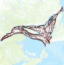
Annual multidisciplinary survey for assessing groundfish and shrimp in the Estuary and northern Gulf of St. Lawrence (CCGS Teleost 2004 - 2022)
Fisheries and Oceans Canada (DFO) conducts an annual summer multidisciplinary scientific survey with a bottom trawl in the Estuary and the northern Gulf of St. Lawrence since 1984. Over the years this survey has been conducted on four vessels: the MV Lady Hammond (1984-1990), the CCGS Alfred Needler (1990-2005), the CCGS Teleost (2004-2022) and the CCGS Cabot (2022-present). It is important to note that the objectives, the methods used and the identification of the species during these surveys have improved over time in response to DFO requests and mandates. The data are therefore not directly comparable between these surveys. However, comparative analyses have been carried out between vessels, and conversion factors are available on request for a number of species. The specificities of the missions onboard the CCGS Teleost are described below.
Objectives:
1. Assess groundfish and northern shrimp population abundance and condition
2. Assess environmental conditions
3. Conduct a biodiversity inventory of benthic and demersal megafauna
4. Assess phytoplankton and mesozooplankton abundance
5. Monitor the pelagic ecosystem
6. Inventory marine mammals populations
7. Inventory seabirds populations
8. Collect samples for various research projects
Survey description
The survey covers the Estuary and the northern Gulf of St. Lawrence, that is the divisions 4R, 4S and the northern part of division 4T of the Northwest Atlantic Fisheries Organization (NAFO). Since 2008, coverage of division 4T has been increased in the upstream part of the Lower Estuary in order to sample the depths between 37 and 183 m. A stratified random sampling strategy is used for this survey and the area of the study area is 118,587 km². The fishing gear used on the CCGS Teleost is a four-sided Campelen 1800 shrimp trawl equipped with a Rockhopper footgear (“bicycle”). The trawl lengthening and codend are equipped with a 12.7-mm knotless nylon lining. Standard trawling tows last 15 minutes, starting from the time the trawl touches the sea floor. The target towing speed is 3 knots.
Data
For each fishing tow, the catch is sorted and weighed by taxa; individuals are then counted and biological data are collected on a subsample. For fish, crab and squid, size and weight are measured by individual and, for some species, sex, gonad maturity, and the weight of certain organs (stomach, liver, gonads) are also evaluated. The soft rays of the anal fin are counted for redfish, and the otoliths are sampled for several species such as Atlantic cod, Atlantic halibut, Greenland halibut, and witch flounder. A roughly 2-kg shrimp sample is sorted and weighed by species (and by stage of maturity for northern shrimp). The shrimps are measured individually. The other invertebrates are counted (no individual measurements) and photographed.
The biological data are divided into 4 files: a “Metadata” file containing set information, a “Catches” file containing catches per set for fish taxa, a a “Carbio” file containing biological and morphometric measurements per individual and a “Shrimps” file containing information on shrimp catches.
It's important to note that this is raw data. Only set considered successful are retained. In each set, all species are kept, with a few exceptions. For more information please contact the data management team (gddaiss-dmsaisb@dfo-mpo.gc.ca ).
Simple
- Date ( RI_367 )
- 2019
- Date ( RI_366 )
- 2019
- Date ( RI_368 )
- 2025
- Status
- onGoing; enContinue RI_596
- Maintenance and update frequency
- asNeeded; auBesoin RI_540
- Keywords ( RI_525 )
-
- St. Lawrence Estuary
- Gulf of St. Lawrence
- Keywords ( RI_530 )
-
- Groundfish, Shrimp, Multidisciplinary survey, Teleost
- Government of Canada Core Subject Thesaurus Thésaurus des sujets de base du gouvernement du Canada ( RI_528 )
-
- Fish
- Fisheries management
- Oceans
- Marine biology
- Aquatic wildlife
- Aquatic ecosystems
- Classification
- unclassified; nonClassifié RI_484
- Use limitation
- Open Government Licence - Canada (http://open.canada.ca/en/open-government-licence-canada)
- Access constraints
- license; licence RI_606
- Use constraints
- license; licence RI_606
- Spatial representation type
- vector; vecteur RI_635
- Metadata language
- fra; CAN
- Metadata language
- eng; CAN
- Character set
- utf8; utf8 RI_458
- Topic category
-
- Biota
- Begin date
- 2004
- End date
- 2022
))
- Reference system identifier
- http://www.epsg-registry.org / EPSG:4326 /
- Distribution format
-
-
CSV
(
unknown
)
-
CSV
(
unknown
)
- OnLine resource
-
Preliminary results from the groundfish and shrimp multidisciplinary survey in August 2018 in the Estuary and northern Gulf of St. Lawrence
(
HTTPS
)
Supporting Document;PDF;eng,fra
- OnLine resource
-
Data dictionary
(
HTTPS
)
Supporting Document;CSV;eng,fra
- OnLine resource
-
Données du Teleost
(
HTTPS
)
Dataset;CSV;fra
- OnLine resource
-
Data Teleost
(
HTTPS
)
Dataset;CSV;eng
- OnLine resource
-
Teleost Map data
(
ESRI REST: Map Service
)
Web Service;ESRI REST;eng
- OnLine resource
-
Teleost Map data
(
ESRI REST: Map Service
)
Web Service;ESRI REST;fra
- OnLine resource
-
Bottom water temperature and salinity in the Estuary and Gulf of St. Lawrence
(
HTTPS
)
Supporting Document;HTML;eng,fra
- OnLine resource
-
Deep water dissolved oxygen in the Estuary and Gulf of St. Lawrence
(
HTTPS
)
Supporting Document;HTML;eng,fra
- OnLine resource
-
Bottom water pH in the Estuary and Gulf of St.Lawrence
(
HTTPS
)
Supporting Document;HTML;eng,fra
- OnLine resource
-
Summer surface conditions – Multidisciplinary surveys
(
HTTPS
)
Supporting Document;HTML;eng,fra
- OnLine resource
-
Demersal fish total biomass in the Estuary and Gulf of St. Lawrence
(
HTTPS
)
Supporting Document;HTML;eng,fra
- OnLine resource
-
Pelagic fish total biomass in the Estuary and Gulf of St.Lawrence
(
HTTPS
)
Supporting Document;HTML;eng,fra
- OnLine resource
-
Demersal fish group richness in the Estuary and Gulf of St. Lawrence
(
HTTPS
)
Supporting Document;HTML;eng,fra
- OnLine resource
-
Pelagic fish group richness in the Estuary and Gulf of St. Lawrence
(
HTTPS
)
Supporting Document;HTML;eng,fra
- OnLine resource
-
Demersal fish species abondance in the Esturay and Gulf of St. Lawrence between 2008 and 2017
(
HTTPS
)
Supporting Document;HTML;eng,fra
- OnLine resource
-
Pelagic fish species abondance in the Esturay and Gulf of St. Lawrence between 2008 and 2017
(
HTTPS
)
Supporting Document;HTML;eng,fra
- File identifier
- 40381c35-4849-4f17-a8f3-707aa6a53a9d XML
- Metadata language
- eng; CAN
- Character set
- utf8; utf8 RI_458
- Hierarchy level
- dataset; jeuDonnées RI_622
- Date stamp
- 2025-04-10T19:16:07.75Z
- Metadata standard name
- North American Profile of ISO 19115:2003 - Geographic information - Metadata
- Metadata standard version
- CAN/CGSB-171.100-2009
Overviews

Spatial extent
Provided by
