 Arctic SDI catalogue
Coastal Environmental Baseline Program (Maritimes Region), Northwest Fundy Shores conductivity, temperature and depth data
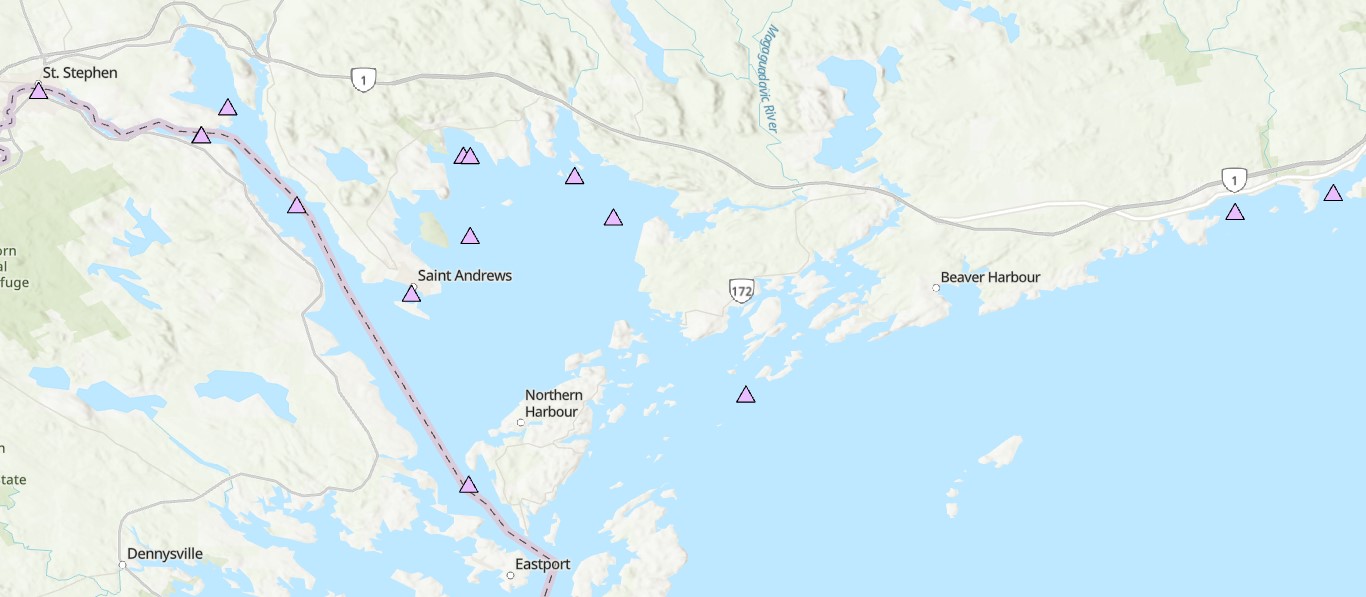
The Coastal Environmental Baseline Program is a multi-year Fisheries and Oceans Canada initiative designed to work with Indigenous and local communities and other key parties to collect coastal environmental data at a series of sites across Canada, to build a better understanding of existing marine ecological conditions. The program began data collection in 2019, and with the onset of Phase 2 in 2023, the Maritimes region study area was expanded and renamed ‘Northwest Fundy Shores’. A physical oceanography program was designed to align with the oceanographic interests and data needs of local interest holders. Starting in 2023, oceanographic parameters including water temperature, salinity, depth and turbidity have been monitored at a series of locations in Passamaquoddy Bay, the St. Croix River, and along the Bay of Fundy coast, including the Musquash estuary Marine Protected Area (MPA). This dataset includes seasonal CTD (conductivity, temperature and depth) and turbidity data starting in spring 2023. Instruments are maintained through the winter months at a limited number of sites. Data collection methods are primarily moored instruments on the bottom in water depths of 5-90 meters, and a few buoyant surface floats. Overall, this dataset captures seasonal dynamics in near-shore marine environments in Passamaquoddy Bay, the St Croix River, the Bay of Fundy and the Musquash MPA.
Cite this data as: Coastal Environmental Baseline Program (Maritimes Region), Northwest Fundy Shores conductivity, temperature and depth data. Published in May 2025. Coastal Environmental Baseline Program. Coastal Ecosystems Science Division, Fisheries and Oceans Canada, St. Andrews, N.B. 14-02-2025
Simple
- Date ( RI_367 )
- 2025-05-07
- Date ( RI_366 )
- 2025-04-07
- Status
- onGoing; enContinue RI_596
- Maintenance and update frequency
- asNeeded; auBesoin RI_540
- Keywords
-
- Water temperature
- Coastal Environmental Baseline Program
- Salinity
- CTD
- Saint John River
- Government of Canada Core Subject Thesaurus Thésaurus des sujets de base du gouvernement du Canada ( RI_528 )
-
- Oceans
- Environment
- Coastal waters
- Inland waters
- Wetlands
- Estuaries
- Ecosystems
- Oceanography
- Classification
- unclassified; nonClassifié RI_484
- Use limitation
- Open Government Licence - Canada (http://open.canada.ca/en/open-government-licence-canada)
- Access constraints
- license; licence RI_606
- Use constraints
- license; licence RI_606
- Spatial representation type
- vector; vecteur RI_635
- Metadata language
- eng; CAN
- Metadata language
- fre; CAN
- Character set
- utf8; utf8 RI_458
- Topic category
-
- Environment
- Biota
- Oceans
- Begin date
- 2023-04-18
- End date
- 2024-05-07
))
- Reference system identifier
- https://epsg.io / EPSG:4326 /
- Distribution format
-
-
FGDB/GDB
(
2.7.0
)
-
ESRI REST
(
2.7.0
)
-
CSV
(
1
)
-
PDF
(
N/A
)
-
FGDB/GDB
(
2.7.0
)
- OnLine resource
-
Coastal Environmental Baseline Program (Maritimes Region) Northwest Fundy Shores conductivity, temperature and depth data (2023)
(
HTTPS
)
Dataset;CSV;eng,fra
- OnLine resource
-
Data dictionary
(
HTTPS
)
Supporting Document;PDF;eng,fra
- OnLine resource
-
Coastal Environmental Baseline Program (Maritimes Region) Northwest Fundy Shores conductivity, temperature and depth data (2023)
(
HTTPS
)
Dataset;FGDB/GDB;eng,fra
- OnLine resource
-
Coastal Environmental Baseline Program (Maritimes Region), Northwest Fundy Shores conductivity, temperature and depth data
(
ESRI REST: Map Service
)
Web Service;ESRI REST;eng
- OnLine resource
-
Coastal Environmental Baseline Program (Maritimes Region), Northwest Fundy Shores conductivity, temperature and depth data
(
ESRI REST: Map Service
)
Web Service;ESRI REST;fra
- File identifier
- 40619839-51e2-4151-9ea9-2e29d42aa948 XML
- Metadata language
- eng; CAN
- Character set
- utf8; utf8 RI_458
- Parent identifier
- Coastal Environmental Baseline Program 7f4b9eb6-805f-4d0b-a597-2d7a44e045d7
- Hierarchy level
- series; série RI_623
- Date stamp
- 2025-05-27T10:35:02.388Z
- Metadata standard name
- North American Profile of ISO 19115:2003 - Geographic information - Metadata
- Metadata standard version
- CAN/CGSB-171.100-2009
Overviews
Spatial extent
Provided by
