 Arctic SDI catalogue
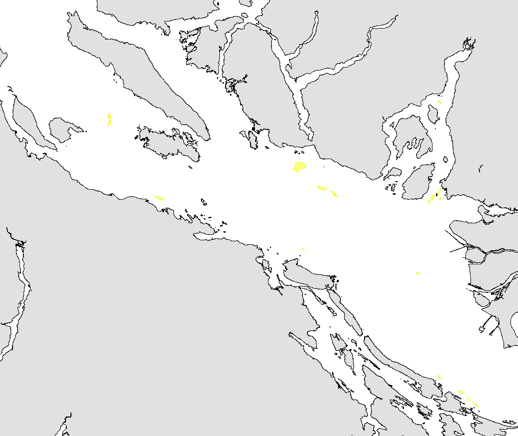
Important Areas for Sponge Reefs in Strait of Georgia Ecoregion
This layer details Important Areas (IAs) relevant to sponge reefs (Hexactinosida) in the Strait of Georgia (SOG) ecoregion. This data was mapped to inform the selection of marine Ecologically and Biologically Significant Areas (EBSA). Experts have indicated that these areas are relevant based upon their high ranking in one or more of three criteria (Uniqueness, Aggregation, and Fitness Consequences). The distribution of IAs within ecoregions is used in the designation of EBSAs.
Canada’s Oceans Act provides the legislative framework for an integrated ecosystem approach to management in Canadian oceans, particularly in areas considered ecologically or biologically significant. DFO has developed general guidance for the identification of ecologically or biologically significant areas. The criteria for defining such areas include uniqueness, aggregation, fitness consequences, resilience, and naturalness. This science advisory process identifies proposed EBSAs in Canadian Pacific marine waters, specifically in the Strait of Georgia (SOG), along the west coast of Vancouver Island (WCVI, southern shelf ecoregion), and in the Pacific North Coast Integrated Management Area (PNCIMA, northern shelf ecoregion).
Initial assessment of IA's in PNCIMA was carried out in September 2004 to March 2005 with spatial data collection coordinated by Cathryn Clarke. Subsequent efforts in WCVI and SOG were conducted in 2009, and may have used different scientific advisors, temporal extents, data, and assessment methods. WCVI and SOG IA assessment in some cases revisits data collected for PNCIMA, but should be treated as a separate effort.
Other datasets in this series detail IAs for birds, cetaceans, fish, geographic features, invertebrates, and other vertebrates.
Though data collection is considered complete, the emergence of significant new data may merit revisiting of IA's on a case by case basis.
Simple
- Date ( RI_367 )
- 2019-11-18
- Date ( RI_366 )
- 2008-10-01
- Date ( RI_368 )
- 2025-08-28
- Status
- completed; complété RI_593
- Maintenance and update frequency
- notPlanned; nonPlanifié RI_542
- Keywords ( RI_528 )
-
- EBSA
- Environmental Planning
- Important Areas
- Marine Ecosystems
- Mulitbeam Bathymetry
- Keywords ( RI_525 )
-
- British Columbia
- Salish Sea
- Strait of Georgia
- Government of Canada Core Subject Thesaurus Thésaurus des sujets de base du gouvernement du Canada ( RI_528 )
-
- Environmental quality
- Ecology
- Classification
- unclassified; nonClassifié RI_484
- Use limitation
- Open Government Licence - Canada (http://open.canada.ca/en/open-government-licence-canada)
- Access constraints
- license; licence RI_606
- Use constraints
- license; licence RI_606
- Spatial representation type
- vector; vecteur RI_635
Spatial resolution
- Metadata language
- eng; CAN
- Character set
- utf8; utf8 RI_458
- Topic category
-
- Oceans
- Begin date
- 2008-10-01
- End date
- 2009-10-30
))
- Supplemental Information
-
Sponge reefs were mapped using multibeam imagery collected using a Simrad EM1002 multibeam swath bathymetry system mounted on the CCGS Vector between 2000 and 2002. The GIS coverage was created using ArcInfo software at the Pacific Geoscience Centre in March, 2005. The presence of sponge reefs was confirmed in most cases by use of remote operated vehicles, sampling or underway acoustic methods such as high resolution seismic on several scientific surveys between 2002 and 2005.
The dataset was updated by Hayley Linton (UVic Co-op student). Multibeam and relief data were used to delimit the sponge reef areas on Ajax Bank near Hornby Island as well as several areas of Howe Sound, September to October 2008.
The dataset was updated in 2019 to conform to MSEA's GIS Hub publication standards. The SOG IA data series was split into taxonomic themes (birds, cetaceans, coral and sponges, fish, geographic features, invertebrates, and other vertebrates). The Check Geometry tool was used to validate each layer.
- Reference system identifier
- https://epsg.io / EPSG:4326 /
- Distribution format
-
-
FGDB/GDB
(
unknown
)
-
GEOJSON
(
Unknown
)
-
FGDB/GDB
(
unknown
)
- OnLine resource
-
Important Areas for Sponge Reefs in SoG Ecoregion
(
ESRI REST: Map Service
)
Web Service;ESRI REST;eng
- OnLine resource
-
Data Dictionary
(
HTTPS
)
Supporting Document;HTML;eng,fra
- OnLine resource
-
Important Areas for Sponge Reefs in SoG Ecoregion - Geodatabase
(
HTTPS
)
Dataset;FGDB/GDB;eng,fra
- OnLine resource
-
Important Areas for Sponge Reefs in SoG Ecoregion - GeoJSON
(
HTTPS
)
Dataset;GEOJSON;eng,fra
- OnLine resource
-
Important Areas for Sponge Reefs in SoG Ecoregion - Shapefiles
(
HTTPS
)
Dataset;SHP;eng,fra
- OnLine resource
-
References
(
HTTPS
)
Supporting Document;HTML;eng,fra
- OnLine resource
-
IA for Sponge Reefs in SoG Ecoregion - GIS Hub metadata
(
HTTPS
)
Supporting Document;PDF;eng
- OnLine resource
-
IA for Sponge Reefs in SoG Ecoregion - GIS Hub metadata
(
HTTPS
)
Supporting Document;PDF;fra
- OnLine resource
-
Important Areas for Sponge Reefs in SoG Ecoregion
(
ESRI REST: Map Service
)
Web Service;ESRI REST;fra
- File identifier
- 422650c4-0dff-460f-a945-84ddf732ad7e XML
- Metadata language
- eng; CAN
- Character set
- utf8; utf8 RI_458
- Hierarchy level
- dataset; jeuDonnées RI_622
- Date stamp
- 2025-08-28T18:57:39.454Z
- Metadata standard name
- North American Profile of ISO 19115:2003 - Geographic information - Metadata
- Metadata standard version
- CAN/CGSB-171.100-2009
Overviews
Spatial extent
Provided by
