 Arctic SDI catalogue
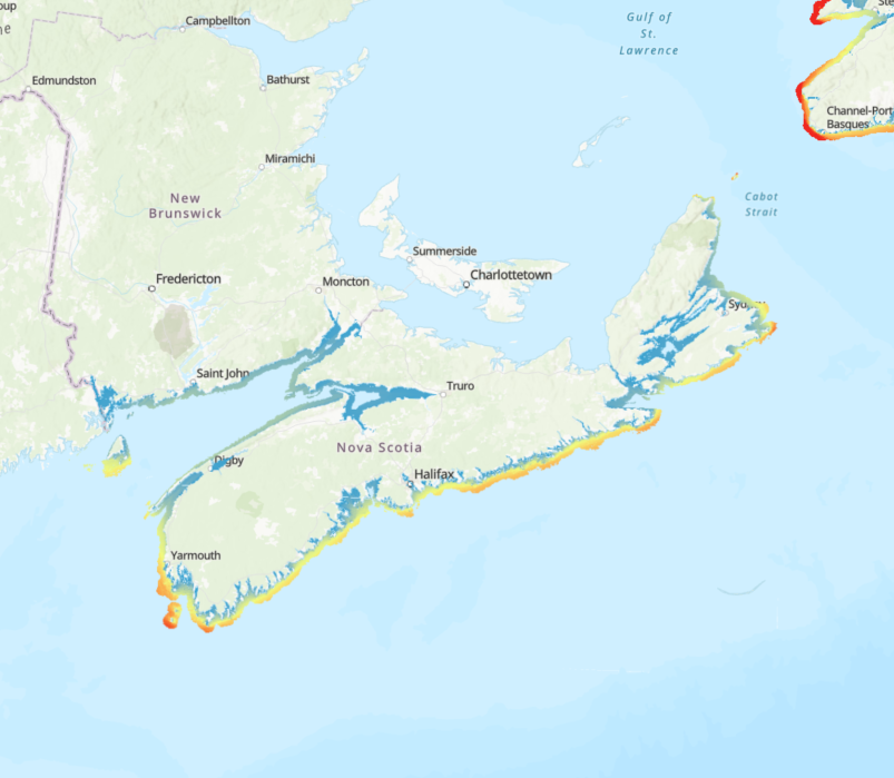
Fetch and relative wave exposure indices for the coastal zone of the Scotian Shelf-Bay of Fundy bioregion
Exposure to wind-driven waves forms a key physical gradient in nearshore environments influencing both ecological communities and human activities. We calculated a relative exposure index (REI) for wind-driven waves covering the coastal zone of the Scotian Shelf-Bay of Fundy bioregion. We derived REI and two other fetch-based indices (sum fetch, minimum fetch) from two formulations of wind fetch (unweighted and effective fetch) for input points in an evenly spaced fishnet grid (50-m resolution) covering a buffered area within 5 km from the coastline and shallower than 50 m depth.
We calculated unweighted fetch lengths (m) for 32 compass headings per input point (11.25° intervals), and effective fetch lengths for 8 headings per point (45° intervals). Unweighted fetch is the distance along a given heading from a point in coastal waters to land. Effective fetch is a directionally weighted average of multiple fetch measures around a given heading that reduces the influence of irregular coastline shape on exposure estimates. For fetch calculations, we used land features at a 1:50,000 scale for Canadian administrative boundaries (NrCan 2017), and unknown resolution for St. Pierre and Miquelon, and US states bordering the Gulf of Maine (GADM 2012). The summed and minimum unweighted fetch lengths for each point provide coarse summaries of wave exposure and distance to land, respectively. The relative exposure index (REI) gives a more accurate metric of exposure by combining effective fetch with modelled wind speeds (m s-1) and frequency data.
We provide the original calculations of unweighted fetch, effective fetch, and other fetch-based indices (i.e., sum, minimum) in csv format along with the REI layer (GeoTIFF format) resampled to 35-m resolution. With broad spatial coverage and high resolution, these indices can support regional-scale distribution modelling of species and biological assemblages in the coastal zone as well as marine spatial planning activities.
When using data please cite following:
O'Brien JM, Wong MC, Stanley RRE (2022) A relative wave exposure index for the coastal zone of the Scotian Shelf-Bay of Fundy Bioregion. figshare. Collection. https://doi.org/10.6084/m9.figshare.c.5433567
References
GADM database of Global Administrative Areas (2012). Global Administrative Areas, version 2.0. (accessed 2 December 2020). www.gadm.org
Natural Resources Canada (2017) Administrative Boundaries in Canada - CanVec Series - Administrative Features - Open Government Portal. (accessed 2 December 2020). https://open.canada.ca/data/en/dataset/306e5004-534b-4110-9feb-58e3a5c3fd97.
Simple
- Date ( RI_367 )
- 2022
- Date ( RI_366 )
- 2022
- Status
- completed; complété RI_593
- Maintenance and update frequency
- asNeeded; auBesoin RI_540
- Keywords ( RI_528 )
-
- Fetch
- Relative Wave Exposure
- Keywords ( RI_525 )
-
- Bay of Fundy
- Scotian Shelf
- Government of Canada Core Subject Thesaurus Thésaurus des sujets de base du gouvernement du Canada ( RI_528 )
-
- Wind
- Coastal waters
- Oceans
- Environment
- Oceanography
- Coasts
- Classification
- unclassified; nonClassifié RI_484
- Use limitation
- Open Government Licence - Canada (http://open.canada.ca/en/open-government-licence-canada)
- Access constraints
- license; licence RI_606
- Use constraints
- license; licence RI_606
- Spatial representation type
- grid; grille RI_636
- Metadata language
- eng; CAN
- Topic category
-
- Climatology, meteorology, atmosphere
- Oceans
- Location
- Geoscientific information
- Environment
- Begin date
- 2011
- End date
- 2020
))
- Reference system identifier
- http://www.epsg-registry.org / EPSG:4326 /
- Distribution format
-
-
TIFF
(
Unknown
)
-
TIFF
(
Unknown
)
- OnLine resource
-
Effective_Fetch
(
HTTPS
)
Dataset;CSV;eng,fra
- OnLine resource
-
Min_Sum_Fetch
(
HTTPS
)
Dataset;CSV;eng,fra
- OnLine resource
-
Unweighted_Fetch
(
HTTPS
)
Dataset;CSV;eng,fra
- OnLine resource
-
Relative_Exposure_Index
(
HTTPS
)
Dataset;TIFF;eng,fra
- OnLine resource
-
Relative Exposure Indices
(
ESRI REST: Map Server
)
Web Service;ESRI REST;eng
- OnLine resource
-
DataDictionary_DictionnaireDeDonnées
(
HTTPS
)
Supporting Document;CSV;eng,fra
- OnLine resource
-
Relative Exposure Index
(
ESRI REST: Map Server
)
Web Service;ESRI REST;fra
- File identifier
- 42478434-e0ac-4f40-a4ac-aec40f161a9c XML
- Metadata language
- eng; CAN
- Character set
- utf8; utf8 RI_458
- Parent identifier
- Fetch and relative wave exposure indices for the coastal zones of the Scotian Shelf-Bay of Fundy and Newfoundland-Labrador Shelves bioregions 9f43c64c-4cbc-4e54-8199-7765331445f3
- Hierarchy level
- dataset; jeuDonnées RI_622
- Date stamp
- 2025-02-06T12:40:31.223Z
- Metadata standard name
- North American Profile of ISO 19115:2003 - Geographic information - Metadata
- Metadata standard version
- CAN/CGSB-171.100-2009
Overviews
Spatial extent
Provided by
