 Arctic SDI catalogue
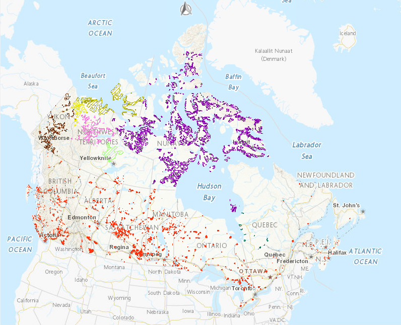
Aboriginal Lands of Canada Legislative Boundaries
The Aboriginal Lands of Canada Legislative Boundaries web service includes legislative boundaries of Indian Reserves, Land Claim Settlement Lands (lands created under Comprehensive Land Claims Process that do not or will not have Indian Reserve status under the Indian Act) and Indian Lands. More specifically it includes the following lands: 1) Indian Reserves that include: 1.1) surrendered lands or a reserve, as defined in the Indian Act (this definition excludes Indian Settlements and Indian Communities); and 1.2) Sechelt lands, as defined in the Sechelt Indian Band Self-Government Act, chapter 27 of the Statutes of Canada, 1986; 2) Land Claim Settlement Lands that include: 2.1) Category IA land or Category IA-N land, as defined in the Cree-Naskapi (of Quebec) Act, chapter 18 of the Statutes of Canada, 1984 (category 1B and category II Lands are excluded from this definition); 2.2) Settlement land, as defined in the Yukon First Nations Self-Government Act, and lands in which an interest is transferred or recognized under section 21 of that Act (only Yukon First Nations Settlement Lands, which were surveyed and the survey plan recorded, are included in the map service); 2.3) Inuit Owned Lands as defined in the Agreement between the Inuit of the Nunavut Settlement Area and Her Majesty the Queen in Right of Canada given effect and declared valid by the Nunavut Land Claims Agreement Act (it includes all parcels that have been surveyed and those that do not require a survey (this includes the islands)); 2.4) Gwich’in Lands as defined in the Gwich’in Comprehensive Land Claim Agreement, given effect and declared valid by the Gwich’in Land Claim Settlement Act; 2.5) Inuvialuit Lands as defined in the Western Arctic (Inuvialuit) Claims Settlement Act; 2.6) Sahtu Lands as defined in The Sahtu Dene and Métis Comprehensive Land Claim Agreement given effect and declared valid by the Sahtu Dene and Métis Land Claim Settlement Act; and 2.7) Tlicho lands, as defined in the Tlicho Agreement, given effect and declared valid by the Tlicho Land Claims and Self-Government Act; 3) Indian Lands that include: 3.1) Lands in the Kanesatake Mohawk interim land base, as defined in the Kanesatake Mohawk Interim Land Base Governance Act, other than the lands known as Doncaster Reserve No. 17.
The data available for download is the former Geobase-Aboriginal Lands product. There are some attribute differences between the data available for download and the web service; however both contain the same underlying data. Please refer to the Supporting Documents for additional information on the Geobase - Aboriginal Lands dataset. Work is under way to align these two data products.
Simple
- Date ( RI_366 )
- 2016-02-03
- Date ( RI_367 )
- 2017-07-28
- Status
- onGoing; enContinue RI_596
- Maintenance and update frequency
- monthly; mensuel RI_536
- Keywords ( RI_528 )
-
- Canada Lands
- Indian reserves
- Government of Canada Core Subject Thesaurus Thésaurus des sujets de base du gouvernement du Canada ( RI_528 )
-
- Land management
- Aboriginal lands
- Land claims
- Boundaries
- Use limitation
- Open Government Licence - Canada (http://open.canada.ca/en/open-government-licence-canada)
- Access constraints
- license; licence RI_606
- Use constraints
- license; licence RI_606
- Spatial representation type
- vector; vecteur RI_635
- Metadata language
- eng; CAN
- Metadata language
- fra; CAN
- Topic category
-
- Boundaries
- Begin date
- 2004-04-02
))
- Reference system identifier
- / EPSG:3979 /
- Distribution format
-
-
WMS
(
1.3.0
)
-
ESRI REST
(
10.3.1
)
-
WMS
(
1.3.0
)
- OnLine resource
-
Aboriginal Lands of Canada Legislative Boundaries
(
OGC:WMS
)
Web Service;WMS;eng
- OnLine resource
-
Aboriginal Lands of Canada Legislative Boundaries
(
OGC:WMS
)
Web Service;WMS;fra
- OnLine resource
-
Aboriginal Lands of Canada Legislative Boundaries
(
ESRI REST: Map Service
)
Web Service;ESRI REST;fra
- OnLine resource
-
Canada Lands Survey System - CLSS Map Browser (English)
(
HTTP
)
Application;Web App;eng
- OnLine resource
-
Canada Lands Survey System - CLSS Map Browser (French)
(
HTTP
)
Application;Web App;fra
- OnLine resource
-
Aboriginal Lands of Canada Legislative Boundaries
(
ESRI REST: Map Service
)
Web Service;ESRI REST;eng
- OnLine resource
-
Find, visualize and download files via the Index of Geospatial Products HTML
(
HTTP
)
Application;HTML;eng
- OnLine resource
-
Find, visualize and download files via the Index of Geospatial Products HTML
(
HTTP
)
Application;HTML;fra
- OnLine resource
-
Find, visualize and download files via the Index of Aboriginal Lands
(
HTTP
)
Dataset;KMZ;eng,fra
- OnLine resource
-
Download SHP file through HTTP
(
HTTP
)
Dataset;SHP;eng,fra
- OnLine resource
-
Download file Aboriginal Lands, Data Product Specifications through HTTP
(
HTTP
)
Supporting Document;PDF;eng
- OnLine resource
-
Download file Terres autochtones, Spécifications de produit through HTTP
(
HTTP
)
Supporting Document;PDF;fra
- OnLine resource
-
Download file Aboriginal Lands, Conceptual Data Model through HTTP
(
HTTP
)
Supporting Document;PDF;eng
- OnLine resource
-
Download file Terres autochtones, Modèle de données conceptuel through HTTP
(
HTTP
)
Supporting Document;PDF;fra
- OnLine resource
-
Download file Terres autochtones, Catalogue d'entités through HTTP
(
HTTP
)
Supporting Document;PDF;fra
- OnLine resource
-
Download file Aboriginal Lands, Feature Catalogue through HTTP
(
HTTP
)
Supporting Document;PDF;eng
- OnLine resource
-
Download file Terres autochtones, Formats de distribution du produit through HTTP
(
HTTP
)
Supporting Document;PDF;fra
- OnLine resource
-
Download file Aboriginal Lands, Product Distribution Formats through HTTP
(
HTTP
)
Supporting Document;PDF;eng
- OnLine resource
-
Download file Données vectorielles nationales - Règles d'identification through HTTP
(
HTTP
)
Supporting Document;PDF;fra
- OnLine resource
-
Download file National Vector Data - Identification Rules through HTTP
(
HTTP
)
Supporting Document;PDF;eng
- OnLine resource
-
Download file Données vectorielles nationales - Gestion des modifications through HTTP
(
HTTP
)
Supporting Document;PDF;fra
- OnLine resource
-
Download file National Vector Data, Change Management through HTTP
(
HTTP
)
Supporting Document;PDF;fra
- OnLine resource
-
Download SHP (French) file of the changes from the previous version through HTTP
(
HTTP
)
Dataset;SHP;fra
- OnLine resource
-
Download SHP (English) file of the changes from the previous version through HTTP
(
HTTP
)
Dataset;SHP;eng
- OnLine resource
-
Download GML file through HTTP
(
HTTP
)
Dataset;GML;eng,fra
- OnLine resource
-
Download KML file through HTTP
(
HTTP
)
Dataset;KML;eng,fra
- File identifier
- 522b07b9-78e2-4819-b736-ad9208eb1067 XML
- Metadata language
- eng; CAN
- Character set
- utf8; utf8 RI_458
- Hierarchy level
- dataset; jeuDonnées RI_622
- Date stamp
- 2023-10-30T14:00:22
- Metadata standard name
- North American Profile of ISO 19115:2003 - Geographic information - Metadata
- Metadata standard version
- CAN/CGSB-171.100-2009
Overviews
Spatial extent
Provided by
