 Arctic SDI catalogue
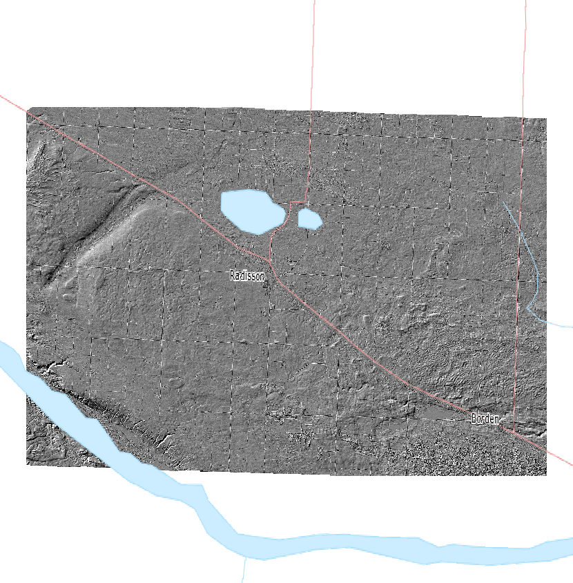
Redberry Lake Biosphere Reserve – 1 meter Full Feature Hillshade
One meter hillshade generated from full feature DEM.
LiDAR Services International (LSI), a Calgary-based LiDAR company completed an airborne LiDAR survey for the Redberry Lake Biosphere Reserve (RLBR) and Agriculture and Agri-Foods Canada (AAFC) in October 2011. The project involved collection of LiDAR data for a 362.97 km2 block area, 252.77 km2 for Redberry Lake and 110.20 km2 for AAFC northwest of Saskatoon, SK.
Simple
- Date ( RI_367 )
- 2011-10-31
- Date ( RI_366 )
- 2011-10-31
- Presentation form
- mapDigital;carteNumérique RI_391
- Status
- completed; complété RI_593
- Maintenance and update frequency
- notPlanned; nonPlanifié RI_542
- Government of Canada Core Subject Thesaurus Thésaurus des sujets de base du gouvernement du Canada ( RI_528 )
-
- Topography
- Use limitation
- Open Government Licence - Canada (http://open.canada.ca/en/open-government-licence-canada)
- Access constraints
- license; licence RI_606
- Use constraints
- license; licence RI_606
- Spatial representation type
- grid; grille RI_636
- Metadata language
- eng; CAN
- Topic category
-
- Elevation
- Begin date
- 2011-10-31
- End date
- 2011-10-31
))
- Reference system identifier
- http://www.epsg.org / EPSG:3857 / 8.3.4
- OnLine resource
-
Redberry Lake Biosphere Reserve LiDAR Survey Report
(
HTTPS
)
Supporting Document;PDF;eng
- OnLine resource
-
Data Product Specification (English)
(
HTTPS
)
Supporting Document;PDF;eng
- OnLine resource
-
Redberry Lake Biosphere Reserve Data Supply and License Agreement
(
HTTPS
)
Supporting Document;PDF;eng
- OnLine resource
-
Pre-packaged GeoTIF files (No linguistic component)
(
HTTPS
)
Dataset;GeoTIF;zxx
- OnLine resource
-
Data Product Specification (French)
(
HTTPS
)
Supporting Document;PDF;fra
- File identifier
- 52657d59-35ac-4b49-a55d-1dd50db889dc XML
- Metadata language
- eng; CAN
- Character set
- utf8; utf8 RI_458
- Parent identifier
- Redberry Lake Biosphere Reserve LiDAR Survey 9979faa9-b96f-41ce-bbd5-e0733e7ad04a
- Hierarchy level
- dataset; jeuDonnées RI_622
- Date stamp
- 2022-12-13T18:02:56
- Metadata standard name
- North American Profile of ISO 19115:2003 - Geographic information - Metadata
- Metadata standard version
- CAN/CGSB-171.100-2009
Overviews
Spatial extent
Provided by
