 Arctic SDI catalogue
The MPMO Project Inventory - August, 2019 Snapshot
Simple
- Date ( RI_366 )
- 2019-09-30
- Date ( RI_367 )
- 2019-12-11
- Date ( RI_368 )
- 2022-01-11
- Status
- historicalArchive; archiveHistorique RI_594
- Maintenance and update frequency
- notPlanned; nonPlanifié RI_542
- Government of Canada Core Subject Thesaurus Thésaurus des sujets de base du gouvernement du Canada ( RI_528 )
-
- Primary industry
- Cartography
- Geographic data
- Use limitation
- Open Government Licence - Canada (http://open.canada.ca/en/open-government-licence-canada)
- Access constraints
- license; licence RI_606
- Use constraints
- license; licence RI_606
- Spatial representation type
- vector; vecteur RI_635
- Metadata language
- eng
- Metadata language
- fra
- Character set
- utf8; utf8 RI_458
- Topic category
-
- Economy
- Begin date
- 2012
- End date
- 2019
))
- Reference system identifier
- http://www.epsg-registry.org / EPSG:3978 /
- Distribution format
-
-
FGDB/GDB
(
10
)
-
ESRI REST
(
10.7.1
)
-
FGDB/GDB
(
10
)
- OnLine resource
-
MPMO - Major Projects, August 2019
(
ESRI REST: Map Server
)
Web Service;ESRI REST;eng
- OnLine resource
-
MPMO - Major Projects, August 2019
(
ESRI REST: Map Server
)
Web Service;ESRI REST;fra
- OnLine resource
-
MPMO - Major Projects, August 2019
(
HTTPS
)
Dataset;FGDB/GDB;fra
- OnLine resource
-
MPMO - Major Projects, August 2019
(
HTTPS
)
Dataset;FGDB/GDB;eng
- File identifier
- 52baeb21-9dc2-42f7-b944-8bbe4b4b66a0 XML
- Metadata language
- eng; CAN
- Character set
- utf8; utf8 RI_458
- Hierarchy level
- dataset; jeuDonnées RI_622
- Date stamp
- 2022-01-11T14:14:23
- Metadata standard name
- North American Profile of ISO 19115:2003 - Geographic information - Metadata
- Metadata standard version
- CAN/CGSB-171.100-2009
Overviews


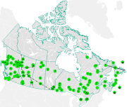
Spatial extent
Provided by
