 Arctic SDI catalogue
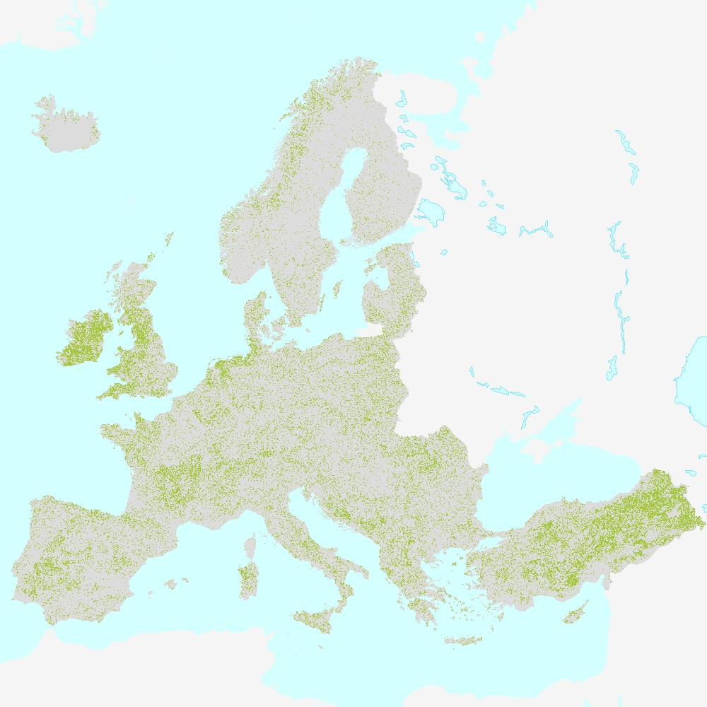
Grassland 2018 (raster 100 m), Europe, 3-yearly, Aug. 2020
The HRL Grassland 2018 100 m aggregate raster product provides a basic land cover classification with two thematic classes (grassland / non-grassland) at 100m spatial resolution, covering the EEA38 area and the United Kingdom. The production of the High Resolution Grassland layers was coordinated by the European Environment Agency (EEA) in the frame of the EU Copernicus programme.
The main High Resolution Grassland product is the Grassland layer. This grassy and non-woody vegetation baseline product includes all kinds of grasslands: managed grassland, semi-natural grassland and natural grassy vegetation. It is a binary status layer for the 2015 reference year mapping grassland and all non-grassland areas in 20m and (aggregated) 100m pixel size and, for the 2018 reference year, in 10m and (aggregated) 100m pixel size.
The 100 meter aggregate raster is provided as a full EEA38 and United Kingdom mosaic (fully conformant with the EEA reference grid).
You can read more about the product here: https://land.copernicus.eu/en/products/high-resolution-layer-grassland/grassland-2018.
Simple
- Date ( Creation )
- 2020-08-18
- Date ( Publication )
- 2020-08-18
- Edition
- 01.00
- Identifier
- copernicus_r_3035_100_m_gra-2018_p_2018_v01_r00
- Identifier
- DAT-201-en
- Unique resource identifier
- 10.2909/5ebf3d6e-b148-4d22-b5e5-173a9d8fd661
- Maintenance and update frequency
- Continual
- GEMET - INSPIRE themes, version 1.0 ( Theme )
-
- Land cover
- Keywords
-
- Continents, countries, sea regions of the world. ( Place )
-
- United Kingdom
- EEA38 (from 2020)
- Keywords
-
- GEMET ( Theme )
-
- forest management
- land use
- land cover
- landscape alteration
- grassland
- Spatial scope ( Theme )
- EEA Management Plan ( Theme )
-
- 2018 3.6.1
- EEA topics ( Theme )
-
- Land use
- Access constraints
- Other restrictions
- Other constraints
- no limitations to public access
- Use constraints
- Other restrictions
- Other constraints
-
The Copernicus component is governed by Regulation (EU) No 2021/696 of the European Parliament and of the Council of 28 April 2021 establishing the Union Space Programme and the European Union Agency for the Space Programme and repealing Regulations (EU) No 912/2010, (EU) No 1285/2013 and (EU) No 377/2014 and Decision No 541/2014/EU. Within the Copernicus component, a portfolio of land monitoring activities has been delegated by the European Union to the European Environment Agency (EEA) and the DG Joint Research Centre of the European Commission.
The Copernicus land monitoring products and services are made available on a principle of full, open and free access, as established by the Commission Delegated Regulation (EU) No 1159/2013 of 12 July 2013.
Free, full and open access to the products and services of the Copernicus Land Monitoring Service is made on the conditions that:
1. When distributing or communicating Copernicus Land Monitoring Service products and services (data, software scripts, web services, user and methodological documentation and similar) to the public, users shall inform the public of the source of these products and services.
2. Where the Copernicus Land Monitoring Service products and services have been adapted or modified by the user, the user shall clearly state this.
3. Users shall make sure not to convey the impression to the public that the user's activities are officially endorsed by the European Union.
- Aggregate Datasetindentifier
- b77b7ce3-04f8-44ae-aaae-b5e5af0f9682
- Association Type
- Cross reference
- Spatial representation type
- Grid
- Distance
- 100 m
- Metadata language
- en
- Character set
- UTF8
- Topic category
-
- Environment
- Imagery base maps earth cover
- Begin date
- 2018-03-01
- End date
- 2018-10-31
))
- Unique resource identifier
- EPSG:3035
- Distribution format
-
-
GeoTIFF
(
1.0
)
-
GeoTIFF
(
1.0
)
- OnLine resource
- Download (requires authentication) ( WWW:LINK-1.0-http--link )
- OnLine resource
- https://doi.org/10.2909/5ebf3d6e-b148-4d22-b5e5-173a9d8fd661 ( DOI )
- Hierarchy level
- Dataset
Conformance result
- Date ( Publication )
- 2010-12-08
- Explanation
- See the referenced specification
- Statement
-
The primary grassland status layer at 10m spatial resolution was produced with a hierarchical spatio-temporal classification of time features derived from Sentinel-2A+B time series (Level-2A data) using a Random Forest (RF) classifier with 200 trees. The selected time window ranges from 01-02-2018 to 30-11-2018, adapted to regional conditions where needed. In total, 137 statistical time features have been calculated and more than 700,000 samples were automatically collected from the LUCAS 2018 database, various CLMS products and additional manual sampling. The final product will be accompanied by a series of expert and reference products (PLOUGH, GRAVPI, Confidence Layer).
Quality assurance follows the ISO 9001:2015 standards for Quality Management and comprises of dedicated procedures of quality checks (QA breakpoints) during implementation of the production chain, in order to keep persistent control over the various stages of production, assure fitness-for-purpose of the end-products and that all quality requirements are fulfilled. Priority has been given to the target thematic accuracy to be achieved by each product, as well as to the issues of product consistency (spatial, thematic, temporal) and homogeneity. Quality Assessment: The quality assessment has been performed according to INSPIRE Data Specifications. The data quality elements considered are: (i) Completeness, (ii) Logical Consistency, (iii) positional accuracy, (iv) Thematic Accuracy, (v) Temporal quality and (vi) Usability.
Geometric accuracy (positioning scale): Less than one pixel (10m) according to ortho-rectified satellite image base (Sentinel-2 Level-2A) delivered by ESA.
Thematic target accuracy: 85% overall accuracy within each bio-geographic region.
Achieved overall accuracy: 95.31% with a 95% confidence level applied. Thematic accuracy has been assessed using a stratified random point sampling approach with 11708 points (area weighted), visually interpreted using VHR_IMAGE_2018 data, Sentinel-2 time series data and complemented by additional data sources like LPIS data sets and Google Earth imagery.
- File identifier
- 5ebf3d6e-b148-4d22-b5e5-173a9d8fd661 XML
- Metadata language
- en
- Character set
- UTF8
- Hierarchy level
- Dataset
- Date stamp
- 2025-01-20T15:32:41.073967Z
- Metadata standard name
- ISO 19115/19139
- Metadata standard version
- 1.0
Overviews
Spatial extent
Provided by
