 Arctic SDI catalogue
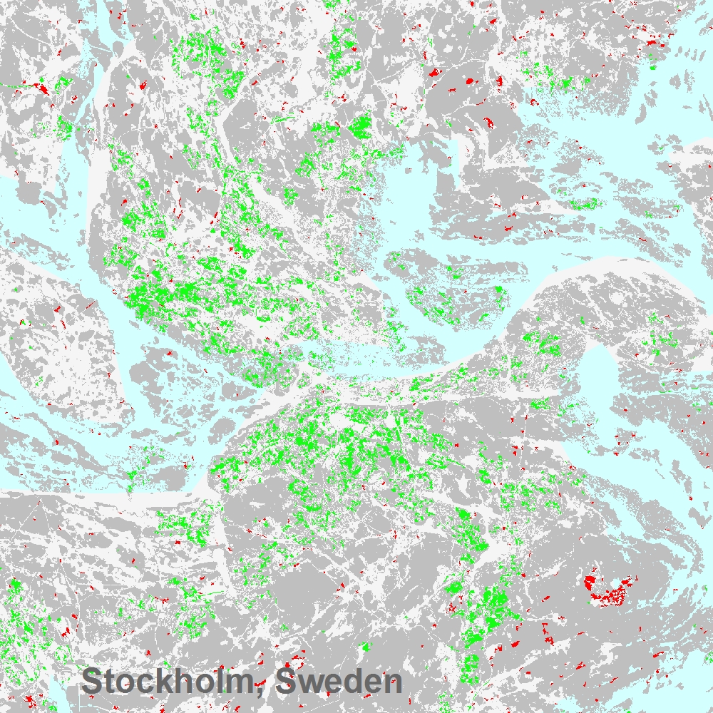
Tree Cover Change Mask 2012-2015 (raster 20 m), Europe, 3-yearly, Dec. 2020
The Copernicus High Resolution Forest Layer Tree Cover Change Mask (TCCM) 2012-2015 raster product provides information on the change between the reference years 2012 and 2015 and consists of 4 thematic classes (unchanged areas with no tree cover / new tree cover / loss of tree cover / unchanged areas with tree cover) at 20m spatial resolution and covers EEA38 area and the United Kingdom. The production of the High Resolution Forest layers was coordinated by the European Environment Agency (EEA) in the frame of the EU Copernicus programme.
The High Resolution Forest product consists of three types of (status) products and additional change products. The status products are available for the 2012, 2015 and 2018 reference years: 1. Tree cover density providing level of tree cover density in a range from 0-100%; 2. Dominant leaf type providing information on the dominant leaf type: broadleaved or coniferous; 3. A Forest type product. The forest type product allows to get as close as possible to the FAO forest definition. In its original (20m) resolution it consists of two products: 1) a dominant leaf type product that has a MMU of 0.5 ha, as well as a 10% tree cover density threshold applied, and 2) a support layer that maps, based on the dominant leaf type product, trees under agricultural use and in urban context (derived from CLC and high resolution imperviousness 2009 data). For the final 100m product trees under agricultural use and urban context from the support layer are removed.
Simple
- Date ( Creation )
- 2020-12-10
- Date ( Publication )
- 2020-12-10
- Edition
- 01.00
- Identifier
- copernicus_r_3035_20_m_tccm-2012-2015_p_2011-2016_v01_00
- Unique resource identifier
- 10.2909/64b34cd9-05b4-4e18-8e7b-15394d3fdb5c
- Maintenance and update frequency
- Continual
- GEMET - INSPIRE themes, version 1.0 ( Theme )
-
- Land cover
- Keywords
-
- Continents, countries, sea regions of the world. ( Place )
-
- EEA38 (from 2020)
- United Kingdom
- Keywords
-
- GEMET ( Theme )
-
- land use
- landscape alteration
- land cover
- forest management
- Spatial scope ( Theme )
- EEA topics ( Theme )
-
- Land use
- Access constraints
- Other restrictions
- Other constraints
- no limitations to public access
- Use constraints
- Other restrictions
- Other constraints
-
The Copernicus component is governed by Regulation (EU) No 2021/696 of the European Parliament and of the Council of 28 April 2021 establishing the Union Space Programme and the European Union Agency for the Space Programme and repealing Regulations (EU) No 912/2010, (EU) No 1285/2013 and (EU) No 377/2014 and Decision No 541/2014/EU. Within the Copernicus component, a portfolio of land monitoring activities has been delegated by the European Union to the European Environment Agency (EEA) and the DG Joint Research Centre of the European Commission.
The Copernicus land monitoring products and services are made available on a principle of full, open and free access, as established by the Commission Delegated Regulation (EU) No 1159/2013 of 12 July 2013.
Free, full and open access to the products and services of the Copernicus Land Monitoring Service is made on the conditions that:
1. When distributing or communicating Copernicus Land Monitoring Service products and services (data, software scripts, web services, user and methodological documentation and similar) to the public, users shall inform the public of the source of these products and services.
2. Where the Copernicus Land Monitoring Service products and services have been adapted or modified by the user, the user shall clearly state this.
3. Users shall make sure not to convey the impression to the public that the user's activities are officially endorsed by the European Union.
- Spatial representation type
- grid Grid
- Distance
- 20 m
- Metadata language
- en
- Character set
- utf8 UTF8
- Topic category
-
- Environment
- Imagery base maps earth cover
- Begin date
- 2011-01-01
- End date
- 2016-12-31
))
- Unique resource identifier
- EPSG:3035
- Distribution format
-
-
GeoTIFF
(
1.0
)
-
GeoTIFF
(
1.0
)
- OnLine resource
- https://image.discomap.eea.europa.eu/arcgis/services/GioLandPublic/HRL_TreeCoverChangeMask_12_15/ImageServer/WMSServer?request=GetCapabilities&service=WMS ( OGC:WMS )
- OnLine resource
- https://image.discomap.eea.europa.eu/arcgis/rest/services/GioLandPublic/HRL_TreeCoverChangeMask_12_15/ImageServer ( ESRI:REST )
- OnLine resource
- Product Information & Technical Documentation ( WWW:LINK )
- OnLine resource
- https://doi.org/10.2909/64b34cd9-05b4-4e18-8e7b-15394d3fdb5c ( DOI )
- OnLine resource
-
CLMS Website
(
WWW:DOWNLOAD
)
Download (requires authentication)
- Hierarchy level
- Dataset
Conformance result
- Date ( Publication )
- 2010-12-08
- Explanation
- See the referenced specification
- Statement
-
The Tree Cover Change Mask (TCCM) 2012-2015 is a change product based on the experimental and unpublished Dominant Leaf Type Change (DLTC) product 2012-2015 from the HRL 2015 production. First, the experimental DLTC product has been recoded to the new TCCM specifications of the HRL 2018 production. Subsequently, the resulting change classes are filtered according to the specified Minimum Mapping Unit (MMU) of 1 ha. The product covers the whole EEA39 area and is provided in European projection. National products might show a broken MMU due to reprojection.
Quality assurance follows the ISO 9001:2015 standards for Quality Management and comprises of dedicated procedures of quality checks (QA breakpoints) during implementation of the production chain, in order to keep persistent control over the various stages of production, assure fitness-for-purpose of the end-products and that all quality requirements are fulfilled. Priority has been given to the target thematic accuracy to be achieved by each product, as well as to the issues of product consistency (spatial, thematic, temporal) and homogeneity. Quality Assessment: The quality assessment has been performed according to INSPIRE Data Specifications. The data quality elements considered are: (i) Completeness, (ii) Logical Consistency, (iii) positional accuracy, (iv) Thematic Accuracy, (v) Temporal quality and (vi) Usability.
Geometric accuracy (positioning scale): Less than one pixel (20m) according to ortho-rectified satellite image base delivered by ESA.
Thematic target accuracy: not assessed.
- File identifier
- 64b34cd9-05b4-4e18-8e7b-15394d3fdb5c XML
- Metadata language
- en
- Character set
- UTF8
- Hierarchy level
- Dataset
- Date stamp
- 2025-10-09T10:54:26.376826Z
- Metadata standard name
- ISO 19115/19139
- Metadata standard version
- 1.0
Overviews
Spatial extent
Provided by
