 Arctic SDI catalogue
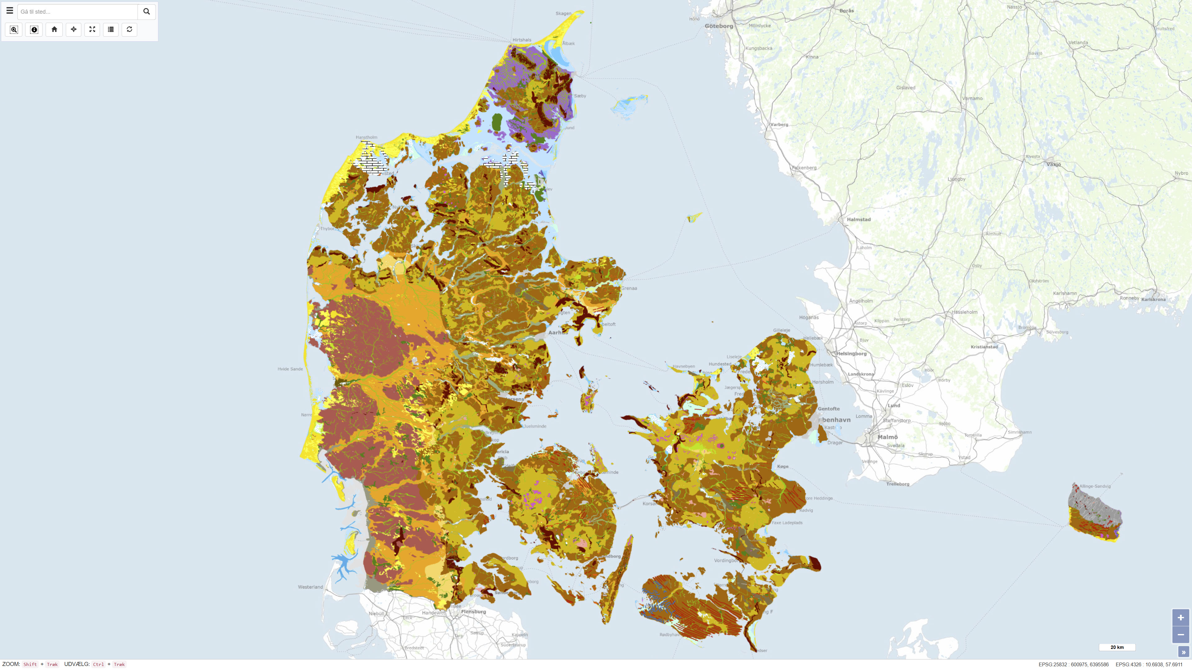
Geomorphological Map of Denmark 1:200.000
The Geomorphological Map of Denmark, version 3 (2022), depicts landscape types across Denmark at a scale of 1:200.000. The landscape types are defined based on shared geomorphological characteristics that can be related to the processes responsible for their formation. Most landscape types were formed during Quaternary glaciations and by meltwater from the glaciers, while the map also includes post-glacial landscapes such as marine and coastal environments, river valleys, lakes and wetlands, as well as aeolian landforms. The map further reflects landscape features influenced by pre-Quaternary bedrock, including exposed crystalline basement on Bornholm and chalk formations in northern Jutland, as well as surface features related to subsurface structural movements. Anthropogenic landscapes resulting from land reclamation, drainage, excavation, and infilling are also represented.
The map is based on systematic geomorphological mapping and interpretation of landforms derived from geological data, terrain analysis and existing cartographic material.
Simple
- Date ( Publication )
- 2022-01-01
- Identifier
- dk.geus / dk_geomorphological_map
- Presentation form
- Digital map
- Purpose
- The purpose of the dataset is to provide a nationwide, consistent, and updated overview of geomorphological landscape types in Denmark. The map is suitable for education, research, landscape analysis, planning, and as a scientific basis for interdisciplinary studies where understanding landscape formation and development is essential.
- Status
- Completed
- Maintenance and update frequency
- As needed
- Keywords ( Theme )
-
- Dataset
- Geomorphology
- Landscape types
- Quaternary
- Denmark
- GIS
- Forskningsemner Forskningsemner ( Theme )
- Geografisk Geografisk ( Place )
- Access constraints
- Other restrictions
- Use constraints
- Other restrictions
- Other constraints
- CC0 1.0
- Spatial representation type
- Vector
- Denominator
- 200000
- Metadata language
- Da
- Character set
- UTF8
- Topic category
-
- Geoscientific information
- Imagery base maps earth cover
- Begin date
- 2013-01-01
- End date
- 2022-01-01
))
- Supplemental Information
- The map is a thematic geomorphological overview map prepared by GEUS that represents the latest comprehensive professional version of the geomorphological map of Denmark. The map is not updated continuously.
- Reference system identifier
- ETRS 89 / UTM 32N (EPSG:25832)
- Distribution format
-
-
WMS
(
)
-
WMTS
(
)
-
REST
(
)
-
WMS
(
)
- OnLine resource
-
Download
(
WWW:DOWNLOAD-1.0-http--download
)
Download dataset from GEUS' Dataverse
- OnLine resource
-
Interactive webmap
(
WWW:LINK-1.0-http--link
)
Interactive map displaying the dataset.
- OnLine resource
-
Geomorfologi
(
ESRI:REST
)
ArcGIS REST Service
- OnLine resource
-
Geomorfologi
(
OGC:WMS-1.3.0-http-get-capabilities
)
ArcGIS WMS Service
- OnLine resource
-
Denmark_Geomorfologi
(
OGC:WMTS-1.0.0-http-get-capabilities
)
ArcGIS WMTS Service
- Hierarchy level
- Dataset
- Statement
-
The geomorphological map of Denmark at a scale of 1:200,000 was produced through systematic mapping and interpretation of landforms. Landform types were interpreted using topographic maps, geological maps and the national digital elevation model of Denmark. Previously published geomorphological maps, landscape descriptions and interpretations from available literature were also incorporated.
The mapping was carried out manually based on an integrated geomorphological assessment of landforms, surface structures and spatial relationships. The map represents a synthesis of geomorphological units generalised to the scale of 1:200,000, and the classification of landforms follows the methodological framework defined for the project.
In version 3, the entire country has been mapped, although terrain striping is not fully mapped in Jutland north of Horsens. Zealand and the islands were mapped in 2013 and revised in 2018, Southern Jutland and Funen were mapped in 2018, and northern Jutland was mapped in 2022. The map reflects the geomorphological understanding at the time of publication.
- File identifier
- 68fdd5ae-8091-4188-b5f2-da43f890b126 XML
- Metadata language
- Danskda
- Character set
- UTF8
- Hierarchy level
- Dataset
- Date stamp
- 2026-03-20T10:30:34.551338Z
- Metadata standard name
- ISO 19115:2003/19139
- Metadata standard version
- 1.0
Overviews
Spatial extent
Provided by
