 Arctic SDI catalogue
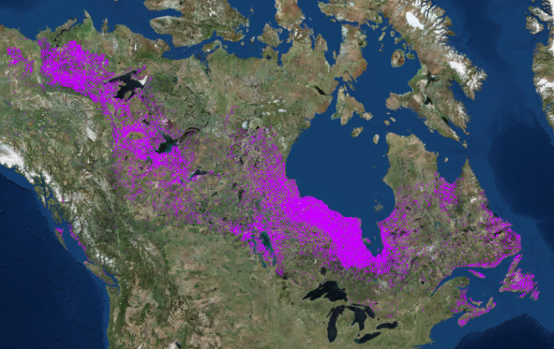
High-resolution binary wetland map for Canada (2001-2016)
High-resolution binary wetland map for Canada (2001-2016). Wetland map for the forested ecosystems of Canada focused on current conditions. It is developed within the framework of Canada’s National Terrestrial Ecosystem Monitoring System (NTEMS).
The binary wetland data included in this product is national in scope (entirety of forested ecosystem) and represents the wall to wall characterization for 2001-2016 (see Wulder et al. 2018). This product was generated using both annual gap free composite reflectance images and annual forest change maps following the Virtual Land Cover Engine (VLCE) process (see Hermosilla et al. 2018), over the 650 million ha forested ecosystems of Canada. Elements of the VLCE classification approach are inclusion of disturbance information in the processes as well as ensuring class transitions over time are logical. Further, a Hidden Markov Model is implemented to assess individual year class likelihoods to reduce variability and possible noise in year-on-year class assignments (for instances when class likelihoods are similar). For this product, to be considered as currently a wetland a pixel must have been classified as wetland at least 80% or 13 of the 16 years between 2001 and 2016, inclusively.
For an overview on the data, image processing, and time series change detection methods applied, see Wulder et al. (2018).
Wulder, M.A., Z. Li, E. Campbell, J.C. White, G. Hobart, T. Hermosilla, and N.C. Coops (2018). A National Assessment of Wetland Status and Trends for Canada’s Forested Ecosystems Using 33 Years of Earth Observation Satellite Data. Remote Sensing.
For a detailed description of the VLCE process and the subsequently generated land cover product, including an accuracy assessment, please see Hermosilla et al. (2018).
Simple
- Date ( RI_367 )
- 2018
- Date ( RI_366 )
- 2018
(250) 363-6004
https://cfs.nrcan.gc.ca/employes/vue/mwulder
- Hours of service
- email only please
- Status
- onGoing; enContinue RI_596
- Maintenance and update frequency
- asNeeded; auBesoin RI_540
- Keywords ( RI_529 )
-
- National Terrestrial Ecosystem Monitoring System (NTEMS)
- Government of Canada Core Subject Thesaurus Thésaurus des sujets de base du gouvernement du Canada ( RI_528 )
-
- Forests
- Use limitation
- Open Government Licence - Canada (http://open.canada.ca/en/open-government-licence-canada)
- Access constraints
- otherRestrictions; autresRestrictions RI_609
- Use constraints
- intellectualPropertyRights; droitsPropriétéIntellectuelle RI_607
- Other constraints
-
The data represents wetlands coverage of Canada's forested ecosystems for 2001-2016. To avoid confusion in areas with dynamic agricultural land use, an agricultural mask was used in the change detection process. Therefore, wetlands in and near agricultural areas may not be captured due to use of this exclusionary mask. An image compositing window of August 1 ± 30 days was used to generate the best-available-pixel (BAP) image composites used as the source data for change detection and attribution. As a result, changes (and hence land class transitions) occurring after August 31 may not always be mapped to the correct year; however a national independent accuracy assessment indicated that 97.7% of changes were labelled to within ± 1 year (Hermosilla et al. 2016; http://www.tandfonline.com/doi/full/10.1080/17538947.2016.118767 )
The science and methods developed to generate the information outcomes shown here, that track and characterize the history of Canada’s forests, were led by Canadian Forest Service of Natural Resources Canada, partnered with the University of British Columbia, with support from the Canadian Space Agency, augmented by processing capacity from WestGrid of Compute Canada.
When using this data, please cite as:
Wulder, M.A., Z. Li, E. Campbell, J.C. White, G. Hobart, T. Hermosilla, and N.C. Coops (2018). A National Assessment of Wetland Status and Trends for Canada’s Forested Ecosystems Using 33 Years of Earth Observation Satellite Data. Remote Sensing.
Hermosilla, T., Wulder, M. A., White, J. C., Coops, N. C., Hobart, G. W., (2018) Disturbance-Informed Annual Land Cover Classification Maps of Canada's Forested Ecosystems for a 29-Year Landsat Time Series, Canadian Journal of Remote Sensing, 44, 67-87, https://doi.org/10.1080/07038992.2018.1437719
- Spatial representation type
- grid; grille RI_636
- Metadata language
- eng
- Topic category
-
- Geoscientific information
))
- Begin date
- 2000-01-17
- End date
- 2016-12-31
- Reference system identifier
- http://www.epsg-registry.org / EPSG:3978 / 1.0
- Distribution format
-
-
GeoTIF
(
1.0
)
-
GeoTIF
(
1.0
)
(250) 363-6004
https://ca.nfis.org/index_eng.html
- Hours of service
- email only please
- OnLine resource
-
Satellite Forest Information for Canada
(
HTTPS
)
Application;HTML;eng
- OnLine resource
-
Satellite Forest Information for Canada (French)
(
HTTPS
)
Application;HTML;fra
- OnLine resource
-
A nationwide annual characterization of 25 years of forest disturbance and recovery for Canada using Landsat time series
(
HTTP
)
Supporting Document;HTML;eng
- OnLine resource
-
CA_wetlands_post2000
(
OGC:WMS
)
Web Service;WMS;eng
- OnLine resource
-
CA_wetlands_post2000.zip
(
HTTPS
)
Dataset;ZIP;zxx
- OnLine resource
-
CA_wetlands_post2000
(
OGC:WMS
)
Web Service;WMS;fra
- OnLine resource
-
A National Assessment of Wetland Status and Trends for Canada’s Forested Ecosystems Using 33 Years of Earth Observation Satellite Data
(
HTTPS
)
Supporting Document;PDF;eng
- OnLine resource
-
Disturbance-Informed Annual Land Cover Classification Maps of Canada's Forested Ecosystems for a 29-Year Landsat Time Series
(
HTTPS
)
Supporting Document;PDF;eng
- File identifier
- 6b1408b4-ea09-4a6a-b5dd-3db3493e1218 XML
- Metadata language
- eng; CAN
- Character set
- utf8; utf8 RI_458
- Hierarchy level
- dataset; jeuDonnées RI_622
- Date stamp
- 2026-02-13T16:47:33
- Metadata standard name
- North American Profile of ISO 19115:2003 - Geographic information - Metadata
- Metadata standard version
- CAN/CGSB-171.100-2009
(250) 363-6004
https://cfs.nrcan.gc.ca/employes/vue/mwulder
- Hours of service
- email only please
Overviews


Spatial extent
Provided by
