 Arctic SDI catalogue
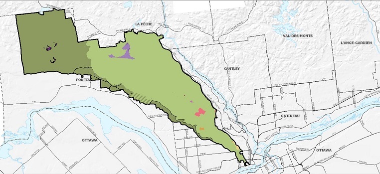
NCC Gatineau Park Land use designations 2021
Described in the Gatineau Park Master plan (2021), the land use designations are the authorized activities or uses in a given area. They support the implementation of the park’s vision and goals. They also ensure that interventions and activities are spatially and functionally consistent.
https://ncc-ccn.gc.ca/our-plans/gatineau-park-master-plan
https://ncc-website-2.s3.amazonaws.com/documents/GPMP_ENG_2021_02_26_Single_Page.pdf#page=65
Simple
- Date ( RI_367 )
- 2021-01-01
- Date ( RI_366 )
- 2021-01-01
- Date ( RI_368 )
- 2022-02-07
- Status
- completed; complété RI_593
- Maintenance and update frequency
- asNeeded; auBesoin RI_540
- Keywords ( RI_528 )
-
- Gatineau
- Park
- Government of Canada Core Subject Thesaurus Thésaurus des sujets de base du gouvernement du Canada ( RI_528 )
-
- Land management
- Planning
- Use limitation
- Open Government Licence - Canada (http://open.canada.ca/en/open-government-licence-canada)
- Access constraints
- license; licence RI_606
- Use constraints
- license; licence RI_606
- Spatial representation type
- vector; vecteur RI_635
- Metadata language
- eng; CAN
- Character set
- utf8; utf8 RI_458
- Topic category
-
- Society
))
- Begin date
- 2022-01-01
- Reference system identifier
- / EPSG:32189 /
- Distribution format
-
-
CSV
(
CSV (Comma delimited)
)
-
KML
(
2.2
)
-
GEOJSON
(
OGC:1.3
)
-
SHP
(
2
)
-
CSV
(
CSV (Comma delimited)
)
- OnLine resource
-
Gatineau Park Land Designation (2021)
(
ESRI REST: Feature Service
)
Web Service;ESRI REST;eng
- OnLine resource
-
NCC Gatineau Park Land Use designations 2021
(
HTTPS
)
Dataset;Web App;fra
- OnLine resource
-
NCC Gatineau Park Land Use designations 2021
(
HTTPS
)
Dataset;Web App;eng
- OnLine resource
-
NCC Gatineau Park Land use designations 2021
(
ESRI REST: Feature Service
)
Web Service;ESRI REST;fra
- File identifier
- 706bf577-0603-4bef-85da-d5c3736081a0 XML
- Metadata language
- eng; CAN
- Character set
- utf8; utf8 RI_458
- Hierarchy level
- dataset; jeuDonnées RI_622
- Date stamp
- 2022-06-29T19:42:01
- Metadata standard name
- North American Profile of ISO 19115:2003 - Geographic information - Metadata
- Metadata standard version
- CAN/CGSB-171.100-2009
Overviews
Spatial extent
Provided by
