 Arctic SDI catalogue
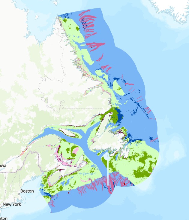
Cumulative risk maps for marine habitats of Atlantic Canada
In marine ecosystems, the combination of multiple, co-occurring human activities can degrade habitats, undermining the very ecosystem services on which human societies depend. To examine the combined risk to marine habitats from multiple, overlapping human activities and stressors in Atlantic Canadian waters, a cumulative habitat risk assessment was conducted across four bioregions: (1) Scotian Shelf-Bay of Fundy, (2) Northern Gulf of St. Lawrence (3) Southern Gulf of St. Lawrence and (4) Newfoundland and Labrador. This analysis combined spatial information for 20 different marine habitats and 36 human activities across five different sectors (climate change, land-based, marine, coastal, and commercial fishing) using a spatially explicit, exposure-consequence risk framework. This dataset provides the cumulative habitat risk map for Atlantic Canadian marine waters at a 1 km² resolution, as well as the habitat map used in the risk analysis. This project was funded by Fisheries and Oceans Canada through a Competitive Science Research Fund (CSRF) grant. For further information concerning specifics of the maps and methods, contact the data provider.
References
Arkema, K.K., Verutes, G., Bernhardt, J.R., et al. 2014. Assessing habitat risk from human activities to inform coastal and marine spatial planning: a demonstration in Belize. Environ. Res. Lett. 9(11): 114016.
Cite this data as: Kelly, N.E. and Murray, C. Cumulative risk maps for marine habitats of Atlantic Canada.
Published: April 2026. Coastal Ecosystems Science Division, Maritimes Region, Fisheries and Oceans Canada, Dartmouth NS.
Simple
- Date ( RI_367 )
- 2026-04-16
- Date ( RI_366 )
- 2026-03-27
- Status
- completed; complété RI_593
- Maintenance and update frequency
- notPlanned; nonPlanifié RI_542
- Keywords ( RI_528 )
-
- Competitive Science Research Fund
- multiple stressors
- risk assessment
- human activities
- cumulative effects
- Government of Canada Core Subject Thesaurus Thésaurus des sujets de base du gouvernement du Canada ( RI_528 )
-
- Oceans
- Use limitation
- Open Government Licence - Canada (http://open.canada.ca/en/open-government-licence-canada)
- Access constraints
- license; licence RI_606
- Use constraints
- license; licence RI_606
- Classification
- unclassified; nonClassifié RI_484
- Spatial representation type
- grid; grille RI_636
- Metadata language
- eng; CAN
- Character set
- utf8; utf8 RI_458
- Topic category
-
- Oceans
- Begin date
- 2009-01-01
- End date
- 2024-12-31
))
- Reference system identifier
- https://epsg.io / EPSG:4326 / 8.2.6
- Distribution format
-
-
ESRI REST
(
2.9.8
)
-
CSV
(
N/A
)
-
FGDB/GDB
(
2.9.8
)
-
TIFF
(
N/A
)
-
ESRI REST
(
2.9.8
)
- OnLine resource
-
Data Dictionary
(
HTTPS
)
Supporting Document;CSV;eng,fra
- OnLine resource
-
Cumulative risk maps for marine habitats of Atlantic Canada
(
HTTPS
)
Dataset;FGDB/GDB;eng,fra
- OnLine resource
-
Cumulative risk maps for marine habitats of Atlantic Canada
(
HTTPS
)
Dataset;TIFF;zxx
- OnLine resource
-
Cumulative risk maps for marine habitats of Atlantic Canada
(
ESRI REST: Map Service
)
Web Service;ESRI REST;eng
- OnLine resource
-
Cumulative risk maps for marine habitats of Atlantic Canada
(
ESRI REST: Map Service
)
Web Service;ESRI REST;fra
- OnLine resource
-
Raster Data Dictionary
(
HTTPS
)
Supporting Document;PDF;eng,fra
- File identifier
- 726984eb-759a-4a5e-b225-075b915bb95d XML
- Metadata language
- eng; CAN
- Character set
- utf8; utf8 RI_458
- Hierarchy level
- dataset; jeuDonnées RI_622
- Date stamp
- 2026-04-17T16:04:47.336934Z
- Metadata standard name
- North American Profile of ISO 19115:2003 - Geographic information - Metadata
- Metadata standard version
- CAN/CGSB-171.100-2009
Overviews
Spatial extent
Provided by
