 Arctic SDI catalogue
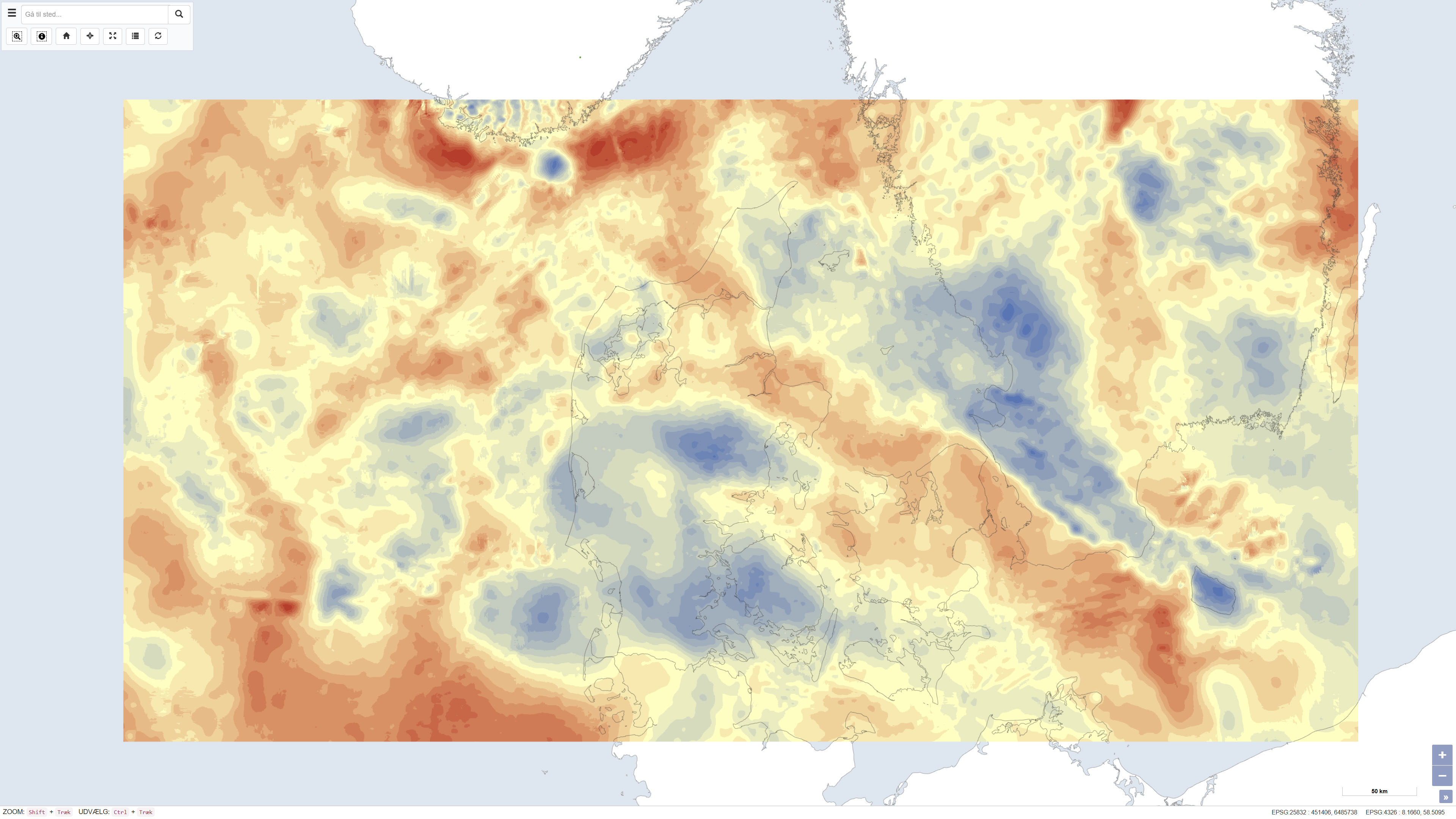
Bouguer and free-air gravity anomalies over Denmark
Simple
- Date ( Publication )
- 2011-12-12
- Identifier
- dk.geus / dk_gravity_bouguer_freeair
- Presentation form
- Digital map
- Purpose
- The purpose of the dataset is to support regional geological, geophysical and structural analyses of the Danish subsurface, including studies of basin structures, fault systems and density variations in bedrock. The map is used as background data in research, mapping and modelling, particularly in combination with seismic, geological and magnetic datasets.
- Status
- Completed
- Maintenance and update frequency
- As needed
- Keywords ( Theme )
-
- Dataset
- Geophysics
- Gravity
- Bouguer anomaly
- Free-air anomaly
- Subsurface
- Forskningsemner Forskningsemner ( Theme )
- Geografisk Geografisk ( Place )
- Access constraints
- Other restrictions
- Use constraints
- Other restrictions
- Other constraints
- This dataset is based on material copyrighted by DTU Space (© 2011). GEUS is not the copyright holder of the original material. Use, redistribution or reproduction may be subject to copyright restrictions and requires permission from the rights holder. Users are responsible for ensuring compliance with applicable copyright legislation.
- Spatial representation type
- Grid
- Denominator
- 500000
- Metadata language
- Da
- Character set
- UTF8
- Topic category
-
- Geoscientific information
))
- Supplemental Information
- The dataset represents a national gravimetric product based on the available measurements at the time of compilation. Variations in data coverage, measurement density and datum definition may introduce local uncertainties. The dataset should therefore be used as a regional background map and in combination with newer or higher-resolution geophysical data where higher precision is required.
- Reference system identifier
- ETRS 89 / UTM 32N (EPSG:25832)
- Distribution format
-
-
WMS
(
)
-
WMTS
(
)
-
REST
(
)
-
WMS
(
)
- OnLine resource
-
Download
(
WWW:DOWNLOAD-1.0-http--download
)
Download dataset from GEUS' Dataverse
- OnLine resource
-
Interactive webmap
(
WWW:LINK-1.0-http--link
)
Interactive map displaying the dataset.
- OnLine resource
-
Gravimetri
(
ESRI:REST
)
ArcGIS REST Service
- OnLine resource
-
Gravimetri_DTU_2011
(
OGC:WMS-1.3.0-http-get-capabilities
)
ArcGIS WMS Service
- OnLine resource
-
Denmark_Gravimetri
(
OGC:WMTS-1.0.0-http-get-capabilities
)
ArcGIS WMTS Service
- Hierarchy level
- Dataset
- Statement
- The dataset is based on gravity measurements provided by DTU Space from the national gravity database. Bouguer anomalies were calculated for land areas using terrain correction, while free-air anomalies were applied in marine areas. Gravity anomalies are expressed in milligals (mGal). A uniform and strictly defined datum is not available for the entire dataset. The projection is defined in UTM based on the WGS84 ellipsoid, while marine data in Danish waters are predominantly related to the ED50 datum. The dataset was finalised on 12/12/2011.
- File identifier
- 7304f06e-1df4-4672-ab35-62fb4b27b65a XML
- Metadata language
- Danskda
- Character set
- UTF8
- Hierarchy level
- Dataset
- Date stamp
- 2026-02-23T13:08:32.961424Z
- Metadata standard name
- ISO 19115:2003/19139
- Metadata standard version
- 1.0
Overviews
Spatial extent
Provided by
