 Arctic SDI catalogue
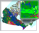
Manitoba Detailed Soil Survey
The Manitoba Detailed Soil Survey dataset series at a scale of 1:100 000 consists of geo-referenced soil polygons with linkages to attribute data found in the associated Component File (CMP), Soil Names File (SNF) and Soil Layer File (SLF).
Together, these datasets describe the spatial distribution of soils and associated landscapes for nearly all agricultural areas in southern Manitoba, as well as some parts of northern and eastern Manitoba.
Simple
- Date ( RI_367 )
- 2013-10-31
- Date ( RI_366 )
- 2013-10-31
- Presentation form
- mapDigital;carteNumérique RI_391
- Status
- completed; complété RI_593
- Maintenance and update frequency
- notPlanned; nonPlanifié RI_542
- Government of Canada Core Subject Thesaurus Thésaurus des sujets de base du gouvernement du Canada ( RI_528 )
-
- Soil taxonomy
- Use limitation
- Open Government Licence - Canada (http://open.canada.ca/en/open-government-licence-canada)
- Access constraints
- license; licence RI_606
- Use constraints
- license; licence RI_606
- Spatial representation type
- vector; vecteur RI_635
- Spatial representation type
- textTable; texteTable RI_637
- Metadata language
- eng; CAN
- Topic category
-
- Geoscientific information
- Begin date
- 2013-01-01
))
- Reference system identifier
- http://www.epsg.org / EPSG: 3857 / 8.3.4
- OnLine resource
-
Pre-packaged FGDB files
(
HTTPS
)
Dataset;FGDB/GDB;eng,fra
- OnLine resource
-
Pre-packaged GeoPackage (GPKG) files
(
HTTPS
)
Dataset;GPKG;eng,fra
- OnLine resource
-
Pre-packaged CSV files
(
HTTPS
)
Dataset;CSV;eng,fra
- OnLine resource
-
Data Product Specification (English)
(
HTTPS
)
Supporting Document;PDF;eng
- OnLine resource
-
Data Product Specification (French)
(
HTTPS
)
Supporting Document;PDF;fra
- File identifier
- 741a06a2-718f-4da9-9adf-6e95c8c37f3d XML
- Metadata language
- eng; CAN
- Character set
- utf8; utf8 RI_458
- Parent identifier
- Detailed Soil Survey 7ed13bbe-fbac-417c-a942-ea2b3add1748
- Hierarchy level
- dataset; jeuDonnées RI_622
- Date stamp
- 2026-01-06T11:42:07
- Metadata standard name
- North American Profile of ISO 19115:2003 - Geographic information - Metadata
- Metadata standard version
- CAN/CGSB-171.100-2009
Overviews
Spatial extent
Provided by
