 Arctic SDI catalogue
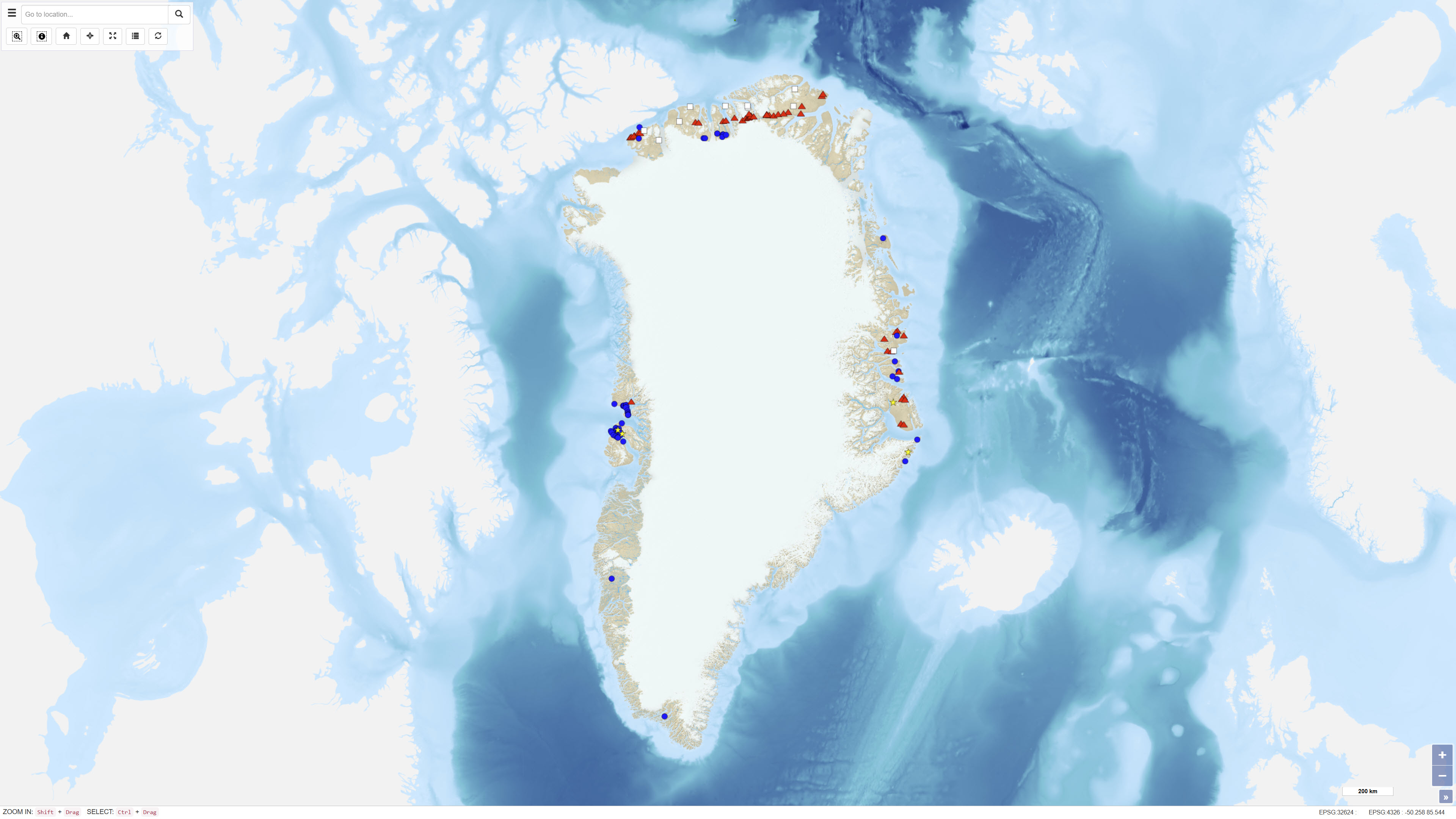
Inventory of Onshore Petroleum Seeps and Stains in Greenland
The dataset comprises a systematic inventory of onshore petroleum seeps and stains in Greenland. The inventory includes information on approximately 130 localities distributed across Palaeozoic, Mesozoic and Cenozoic sedimentary basins in Greenland. For each locality, coordinates, site descriptions, classification of seep type, geological context, sample numbers and references to reports and publications are recorded.
The classification includes oil seeps, gas seeps, mud diapirs and gas-rich springs, oil stains in volcanics, carbonates and sandstones, solid macroscopic bitumen, and fluid inclusions and other evidence of micro-seepage.
The dataset synthesises existing knowledge of petroleum systems in Greenland and provides a comprehensive overview of documented natural hydrocarbon occurrences onshore.
Simple
- Date ( Publication )
- 2021-12-08
- Identifier
- dk.geus / grl_onshore_petroleum_seeps_inventory
- Presentation form
- Digital map
- Purpose
- The purpose of the dataset is to support research and exploration activities by compiling and structuring documented occurrences of natural hydrocarbons onshore in Greenland. The inventory has been developed to facilitate new geological investigations and to improve the understanding of petroleum systems, including source rock distribution, migration, accumulation and degradation processes.
- Status
- Completed
- Maintenance and update frequency
- As needed
- Keywords ( Theme )
-
- Dataset
- Geology
- Petroleum Seeps
- Oil Seeps
- Gas Seeps
- Petroleum Systems
- Hydrocarbons
- Greenland
- Forskningsemner Forskningsemner ( Theme )
- Geografisk Geografisk ( Place )
- Access constraints
- Other restrictions
- Use constraints
- Other restrictions
- Other constraints
- CC BY 4.0
- Other constraints
- The dataset is licensed under the Creative Commons Attribution 4.0 International (CC BY 4.0). Citation: Geological Survey of Denmark and Greenland (GEUS).
- Spatial representation type
- Vector
- Denominator
- 250000
- Metadata language
- en
- Character set
- UTF8
- Topic category
-
- Geoscientific information
- Begin date
- 1960-01-01
- End date
- 2021-08-16
))
- Supplemental Information
- The dataset represents documented and published observations of petroleum seeps and stains and does not constitute a complete inventory of all potential hydrocarbon occurrences in Greenland. Locality classifications and geological interpretations are based on available documentation at the time of registration and may be revised as new information becomes available.
- Reference system identifier
- WGS 84 / UTM 24N (EPSG:32624)
- Distribution format
-
-
WMS
(
)
-
SHP
(
)
-
WMS
(
)
- OnLine resource
-
Download
Download dataset as shapefile
- OnLine resource
-
Interactive webmap
(
WWW:LINK-1.0-http--link
)
Interactive map displaying the dataset.
- OnLine resource
-
Inventory of onshore petroleum seeps and stains in Greenland: a web-based GIS model
(
DOI
)
Christiansen, F. G., & Bojesen-Koefoed, J. A. (2021). Inventory of onshore petroleum seeps and stains in Greenland: a web-based GIS model. GEUS Bulletin, 47. https://doi.org/10.34194/geusb.v47.6519
- OnLine resource
-
inventory_onshore_petr_
(
OGC:WMS-1.3.0-http-get-capabilities
)
WMS for Inventory onshore petroleum
- OnLine resource
-
Download
Download dataset as GeoJSON
- OnLine resource
-
ms:inventory_onshore_petr_
(
OGC:WFS-1.0.0-http-get-capabilities
)
WFS for Inventory onshore petroleum
- Hierarchy level
- Dataset
- Statement
- The dataset has been compiled from published scientific articles, internal and external reports, and field observations collected during decades of geological investigations in Greenland. Information on localities, classification and geochemical analyses has been systematised and harmonised within a unified database. More than 400 samples have been analysed geochemically or described microscopically. The inventory is designed for continuous updates with additional localities, descriptions and new organic geochemical data.
- File identifier
- 7422c656-dd80-4fdd-9e80-00ca70e1487d XML
- Metadata language
- Danskda
- Character set
- UTF8
- Hierarchy level
- Dataset
- Date stamp
- 2026-03-03T14:11:48.745352Z
- Metadata standard name
- ISO 19115:2003/19139
- Metadata standard version
- 1.0
Overviews
Spatial extent
Provided by
