 Arctic SDI catalogue
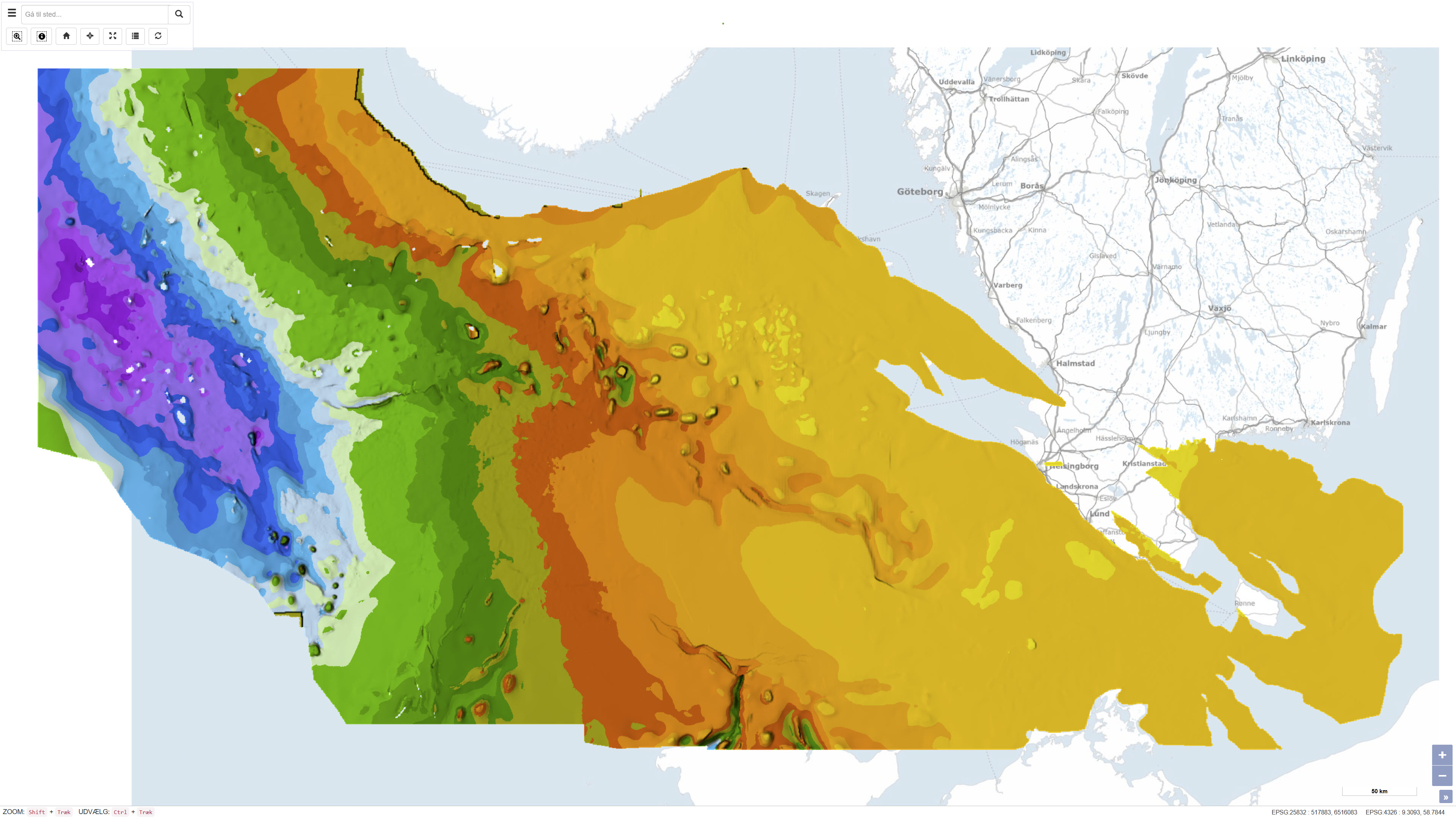
Top Chalk surface in the Danish subsurface
Simple
- Date ( Publication )
- 2007-11-20
- Identifier
- dk.geus / top_kalk
- Presentation form
- Digital map
- Purpose
- The purpose of the dataset is to provide an overview map of the chalk top surface as a structural reference for understanding the subsurface geology, including reservoir conditions, structural geology and depth units in the Danish sector. The dataset supports scientific analyses, resource modelling and geophysical interpretation.
- Status
- Completed
- Maintenance and update frequency
- As needed
- Keywords ( Theme )
-
- Dataset
- Geology
- Top Chalk
- Subsurface
- Denmark
- Seismic
- Forskningsemner Forskningsemner ( Theme )
- Geografisk Geografisk ( Place )
- Access constraints
- Other restrictions
- Use constraints
- Other restrictions
- Other constraints
- CC BY-SA 4.0
- Other constraints
- Use of the dataset requires acknowledgement of the Geological Survey of Denmark and Greenland (GEUS) as the data source.
- Spatial representation type
- Grid
- Denominator
- 400000
- Metadata language
- Da
- Character set
- UTF8
- Topic category
-
- Geoscientific information
- Begin date
- 1970-01-01
- End date
- 2007-11-20
))
- Supplemental Information
- The dataset covers the entire Danish territory – onshore and offshore in the North Sea – and shows significant variations in the chalk top surface. Chalk is an important reservoir rock for oil and gas in the North Sea and serves as an aquifer onshore. The top surface mapping is relevant for the energy sector, hydrogeology and geological research.
- Reference system identifier
- ETRS 89 / UTM 32N (EPSG:25832)
- Distribution format
-
-
WMS
(
)
-
REST
(
)
-
WMS
(
)
- OnLine resource
-
Interactive webmap
(
WWW:LINK-1.0-http--link
)
Interactive map displaying the dataset.
- OnLine resource
-
Mapping of the chalk group in Denmark – GEUS Bulletin
(
WWW:LINK-1.0-http--link
)
Scientific article published in GEUS Bulletin describing the geological and geophysical methods used to map the top, base and thickness of the chalk group in Denmark.
- OnLine resource
-
Mapping of the chalk in Denmark – GEUS Report 2003/106
(
DOI
)
Technical report from GEUS documenting the data basis, seismic interpretation and methodology used for mapping the top chalk surface in the Danish subsurface.
- OnLine resource
-
DetDanskeOmraade
(
ESRI:REST
)
ArcGIS REST Service
- OnLine resource
-
TopKalk_DKomr_depth
(
OGC:WMS-1.3.0-http-get-capabilities
)
ArcGIS WMS Service
- Hierarchy level
- Dataset
- Statement
- The dataset was developed as part of GEUS’s geological mapping initiatives and was described in GEUS Bulletin No. 13 (2007), which published three maps of chalk in Denmark: top chalk surface, base chalk surface, and an isopach map of the chalk group. The maps were produced by integrating extensive seismic data, well data from more than 500 deep oil and gas wells, and mapped information from water boreholes and previous geological interpretations. The interpretations are based on publicly available seismic profiles and geological data compiled up to the early 2000s.
- File identifier
- 74fa74d5-7383-49fa-a8d2-93b410bc4985 XML
- Metadata language
- Danskda
- Character set
- UTF8
- Hierarchy level
- Dataset
- Date stamp
- 2026-03-20T11:04:08.133393Z
- Metadata standard name
- ISO 19115:2003/19139
- Metadata standard version
- 1.0
Overviews
Spatial extent
Provided by
