 Arctic SDI catalogue
The Probabilistic Seismic Risk Model for Canada
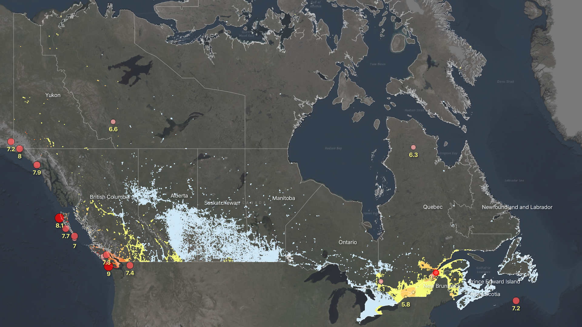
The Probabilistic Seismic Risk Model for Canada introduces a structured framework of indicators that profile the physical, social and economic dimensions of earthquake risk at the neighborhood scale.
Risk metrics include measures of building damage and collapse probability, life safety and expected economic losses. An overall risk rating is also provided which aggregates the physical, social, and economic dimensions of risk. The probabilistic assessment reports information based on both the ‘total’ impact as well as the ‘percentage’ impact.
It considers only damage to buildings, and their inhabitants, from earthquake shaking, and therefore does not include damage to critical infrastructure or vehicles. Losses from secondary hazards, such as aftershocks, liquefaction, landslides, or fire following are also not currently included.
The information is provided at the approximate scale of Census dissemination areas, and is intended to support planning and emergency management activities in earthquake prone regions.
This project is run by the Geological Survey of Canada's Public Safety Geoscience Program. For inquiries related to Canada's Seismic Risk Model, please contact Tiegan E. Hobbs at tiegan.hobbs@nrcan-rncan.gc.ca.
If you are looking for our end-user interface or any associated documentation, please visit www.RiskProfiler.ca.
Simple
- Date ( RI_367 )
- 2021-03
- Date ( RI_366 )
- 2021-03
- Status
- completed; complété RI_593
- Maintenance and update frequency
- asNeeded; auBesoin RI_540
- Keywords ( RI_528 )
-
- earthquake, seismic, risk, building performance, public safety, economic security, disaster resilience planning, policy analysis
- Government of Canada Core Subject Thesaurus Thésaurus des sujets de base du gouvernement du Canada ( RI_528 )
-
- Earthquakes
- Risk management
- Policy development
- Urban planning
- Use limitation
- Open Government Licence - Canada (http://open.canada.ca/en/open-government-licence-canada)
- Access constraints
- license; licence RI_606
- Use constraints
- license; licence RI_606
- Spatial representation type
- vector; vecteur RI_635
- Metadata language
- eng; CAN
- Topic category
-
- Economy
- Geoscientific information
- Planning cadastre
- Society
- Begin date
- 2021
- End date
- 2026
))
- Reference system identifier
- http://www.epsg-registry.org / EPSG:4326 /
- Distribution format
-
-
GPKG
(
1.2
)
-
ESRI REST
(
10.71
)
-
WMS
(
1.3.0
)
-
GPKG
(
1.2
)
- OnLine resource
-
The Probabilistic Seismic Risk model for Canada
(
ESRI REST: Map Server
)
Web Service;ESRI REST;eng
- OnLine resource
-
The Probabilistic Seismic Risk model for Canada
(
ESRI REST: Map Server
)
Web Service;ESRI REST;fra
- OnLine resource
-
The Probabilistic Seismic Risk model for Canada
(
OGC:WMS
)
Web Service;WMS;eng
- OnLine resource
-
The Probabilistic Seismic Risk model for Canada
(
OGC:WMS
)
Web Service;WMS;fra
- OnLine resource
-
Data Products Dictionary
(
HTTPS
)
Supporting Document;XLSX;eng
- OnLine resource
-
Data Products Dictionary
(
HTTPS
)
Supporting Document;XLSX;fra
- OnLine resource
-
PSRA Canada expected loss 500 yr
(
HTTPS
)
Dataset;GPKG;eng
- OnLine resource
-
PSRA Indicators CSD
(
HTTPS
)
Dataset;GPKG;eng
- OnLine resource
-
PSRA Indicators S
(
HTTPS
)
Dataset;GPKG;eng
- File identifier
- 7590d295-5c17-44c8-ad2e-2e8f1a4b6054 XML
- Metadata language
- eng; CAN
- Character set
- utf8; utf8 RI_458
- Hierarchy level
- dataset; jeuDonnées RI_622
- Date stamp
- 2022-12-08T11:18:27
- Metadata standard name
- North American Profile of ISO 19115:2003 - Geographic information - Metadata
- Metadata standard version
- CAN/CGSB-171.100-2009
Overviews
Spatial extent
Provided by
