 Arctic SDI catalogue
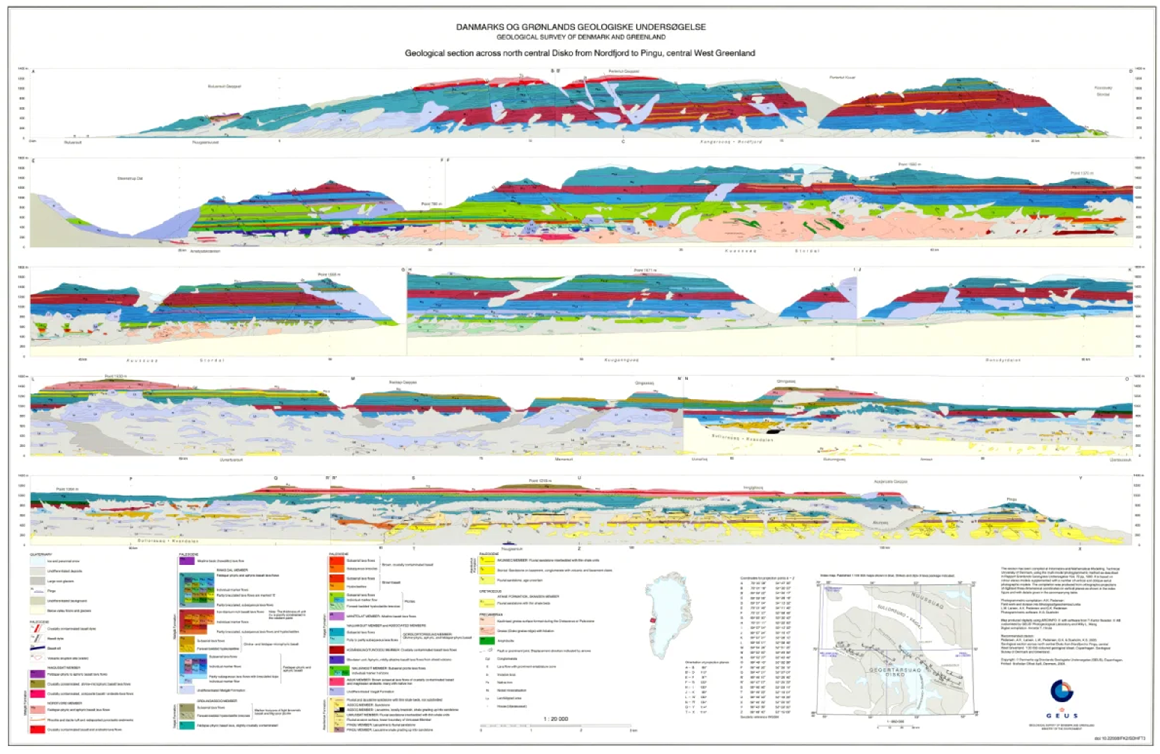
Geological cross sections in Greenland
The dataset comprises a collection of geological cross sections from Greenland derived from multiple geological mapping projects and publications. The cross sections represent interpretations of subsurface geological structures and stratigraphy across selected regions and are associated with published geological maps and reports.
Profile lines have been georeferenced, and the corresponding cross-section images have been digitised and stored as separate PDF files. Each profile is linked to the geological map or publication from which it originates. Due to the diverse origins of the profiles, the level of detail, scale and geological interpretation vary between individual cross sections.
Simple
- Date ( Publication )
- 2016-01-01
- Identifier
- dk.geus / grl_geological_cross_sections_greenland
- Presentation form
- Digital map
- Purpose
- The purpose of the dataset is to provide access to geological cross sections from Greenland as a supplementary resource to geological maps and publications, supporting regional geological interpretation, research and education.
- Status
- Completed
- Maintenance and update frequency
- As needed
- Keywords ( Theme )
-
- Dataset
- Geology
- Stratigraphy
- Structural geology
- Database
- Forskningsemner Forskningsemner ( Theme )
- Geografisk Geografisk ( Place )
- Access constraints
- Other restrictions
- Use constraints
- Other restrictions
- Other constraints
- CC BY 4.0
- Other constraints
- The cross sections represent interpretations derived from different sources and should be used in conjunction with the original publications.
- Spatial representation type
- Vector
- Denominator
- 20000
- Metadata language
- Da
- Character set
- UTF8
- Topic category
-
- Geoscientific information
- Begin date
- 1980-01-01
- End date
- 2016-12-31
))
- Supplemental Information
- The dataset contains cross sections from multiple independent projects and time periods. Content and quality may vary between individual profiles depending on data sources and the purpose of the original work.
- Reference system identifier
- WGS 84 / UTM 24N (EPSG:32624)
- Distribution format
-
-
WMS
(
)
-
SHP
(
)
-
WMS
(
)
-
GeoJSON
(
)
-
WMS
(
)
- OnLine resource
-
Download
Download dataset as shapefile
- OnLine resource
-
Interactive webmap
(
WWW:LINK-1.0-http--link
)
Interactive map displaying the dataset.
- OnLine resource
-
Report
(
DOI
)
Search for publications by GEUS researchers in GEUS' Publications
- OnLine resource
-
GEUS' Webshop
(
WWW:LINK-1.0-http--link
)
Buy or download free maps from GEUS Webshop.
- OnLine resource
-
Download
(
DOI
)
Geological section along the south coast of Disko, central West Greenland. 1:20 000 coloured geological sheet
- OnLine resource
-
ms:gg_profiles
(
OGC:WFS-1.0.0-http-get-capabilities
)
WFS for Profile lines
- OnLine resource
-
gg_profiles
(
OGC:WMS-1.3.0-http-get-capabilities
)
WMS for Profile lines
- OnLine resource
-
Download
Download dataset as GeoJSON
- Hierarchy level
- Dataset
- Statement
-
The dataset is a compilation of geological cross sections originating from different geological mapping projects and published sources. The original cross sections were produced as part of individual geological studies and map publications, including regional geological mapping in Greenland.
For the present dataset, profile lines were georeferenced and the corresponding cross-section figures were digitised and stored as individual PDF files. Each profile retains references to its original source publication or geological map. No attempt has been made to harmonise geological interpretations or scales between the individual cross sections.
- File identifier
- 769323ce-c736-4688-9e9d-bd224f4a9a98 XML
- Metadata language
- Danskda
- Character set
- UTF8
- Hierarchy level
- Dataset
- Date stamp
- 2026-03-01T12:07:37.28904Z
- Metadata standard name
- ISO 19115:2003/19139
- Metadata standard version
- 1.0
Overviews
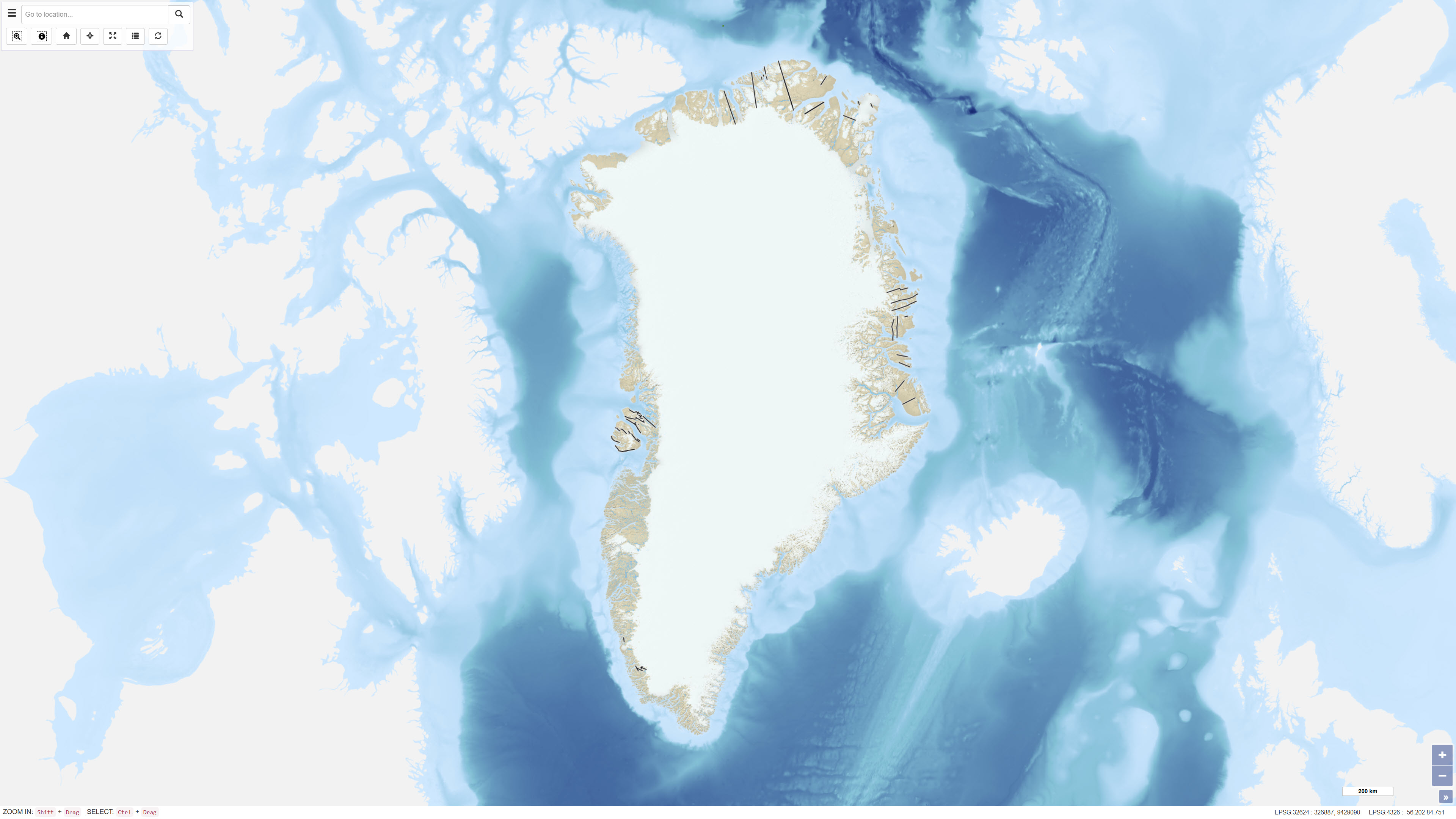
Spatial extent
Provided by
