 Arctic SDI catalogue
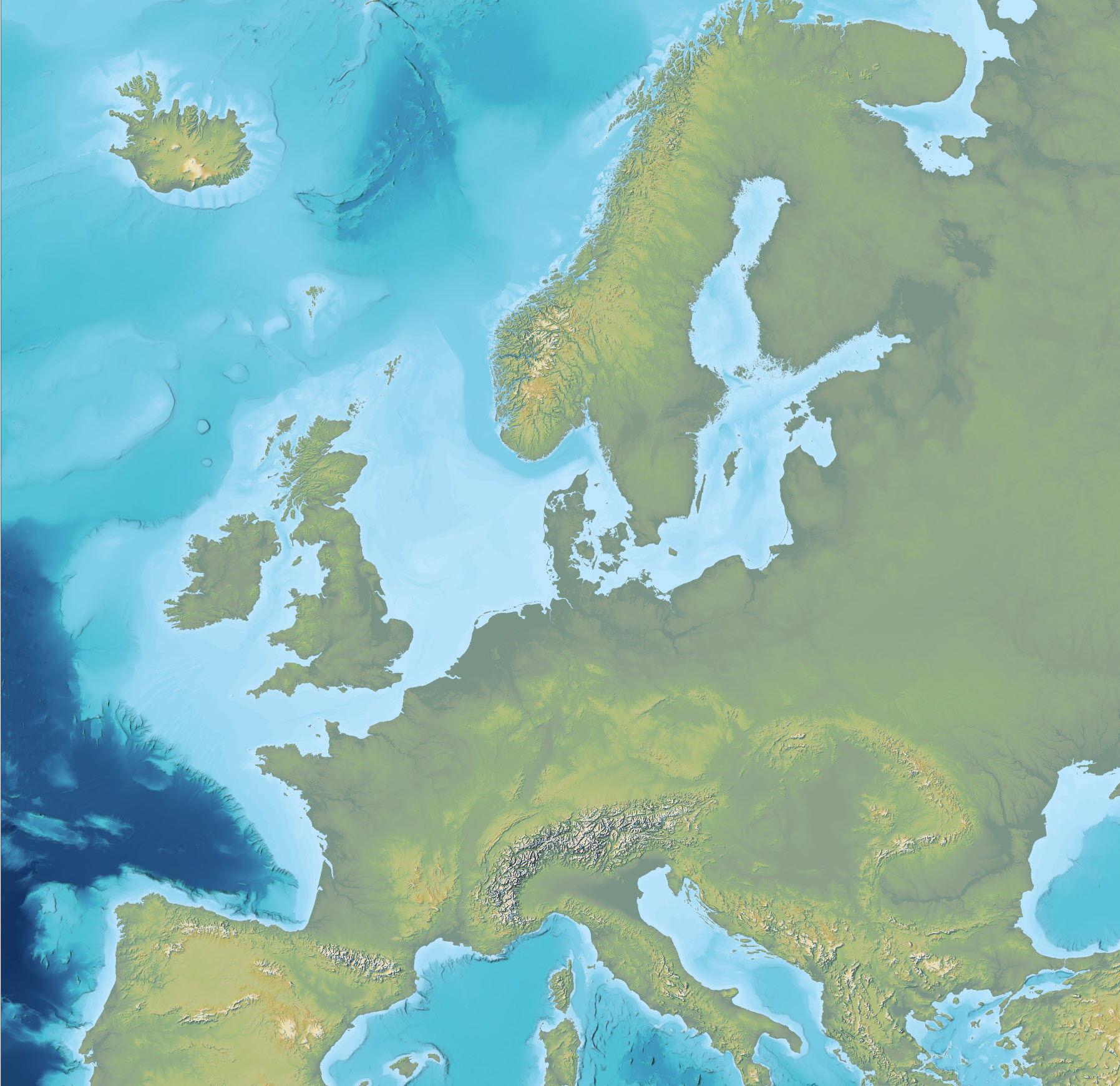
Topography and bathymetry of Europe
Simple
- Date ( Publication )
- 2023-10-05
- Identifier
- dk.geus / eu_imhof_basemap
- Presentation form
- Digital map
- Purpose
- The purpose of the dataset is to provide a consistent and continuous elevation model across land and marine areas where individual source datasets cover only parts of the domain. The dataset has been developed to support visualisation, background mapping, regional analyses and modelling requiring an integrated topographic and bathymetric surface.
- Status
- Completed
- Maintenance and update frequency
- As needed
- Keywords ( Theme )
-
- Dataset
- Digital elevation model
- Topography
- Bathymetry
- Composite dataset
- Terrain model
- GEBCO
- Forskningsemner Forskningsemner ( Theme )
- Geografisk Geografisk ( Place )
- Access constraints
- Other restrictions
- Use constraints
- Other restrictions
- Other constraints
- CC BY 4.0
- Access constraints
- Other restrictions
- Use constraints
- Other restrictions
- Other constraints
- This dataset contains data based on the Copernicus Land Monitoring Service (EU-DEM). Copernicus data are made available on a full, free and open access basis. When distributing or publicly communicating the data, the Copernicus source must be clearly acknowledged. Any adaptations or modifications must be clearly indicated, and the use must not imply official endorsement by the European Union.
- Use limitation
- The GEBCO Grid should NOT be used for navigation or for any other purpose involving safety at sea.
- Access constraints
- Other restrictions
- Use constraints
- Other restrictions
- Other constraints
- The GEBCO Grid (including GEBCO_2023) is placed in the public domain and may be used free of charge. Users must acknowledge the source of the GEBCO Grid, must not imply official status or endorsement by GEBCO, IHO or IOC, and must not mislead others or misrepresent the GEBCO Grid or its source.
- Access constraints
- Other restrictions
- Use constraints
- Other restrictions
- Other constraints
- This dataset contains data based on the Shuttle Radar Topography Mission (SRTM) provided by NASA and the U.S. Geological Survey (USGS). SRTM data are in the public domain and may be used without restriction. Source attribution is recommended.
- Spatial representation type
- Grid
- Denominator
- 150000
- Metadata language
- Da
- Character set
- UTF8
- Topic category
-
- Geoscientific information
- Elevation
- Imagery base maps earth cover
))
- Supplemental Information
-
The dataset is not an authoritative elevation model but a compilation product based on multiple external data sources. Local differences in resolution, accuracy and data quality may occur, particularly in transition zones between land and sea and between the applied source datasets.
The cartographic design is inspired by classical maps produced by cartography professor Eduard Imhof. The colour representation of the topography is based on an Imhof-inspired colour scheme developed by John Nelson (Esri). The dataset is primarily intended for visualisation, base mapping and regional analyses and is not an authoritative elevation model.
- Reference system identifier
- ETRS 89 / UTM 32N (EPSG:25832)
- Distribution format
-
-
WMS
(
)
-
WMTS
(
)
-
REST
(
)
-
WMS
(
)
- OnLine resource
-
Interactive webmap
(
WWW:LINK-1.0-http--link
)
Interactive map displaying the dataset.
- OnLine resource
-
EU-DEM version 1.1
(
WWW:LINK-1.0-http--link
)
EU-DEM v1.1 is a pan-European digital elevation model produced by the European Environment Agency, based on a fusion of SRTM and ASTER GDEM data.
- OnLine resource
-
Shuttle Radar Topography Mission (SRTM) DEM
(
WWW:LINK-1.0-http--link
)
The SRTM DEM provides near-global digital elevation data derived from radar interferometry collected during the Shuttle Radar Topography Mission.
- OnLine resource
-
GEBCO 2023 Grid
(
WWW:LINK-1.0-http--link
)
The GEBCO 2023 Grid is a global bathymetric grid providing information on seafloor topography, compiled by the GEBCO community.
- OnLine resource
-
Denmark_Imhof_basemap
(
ESRI:REST
)
ArcGIS REST Service
- OnLine resource
-
Land
(
OGC:WMS-1.3.0-http-get-capabilities
)
ArcGIS WMS Service
- OnLine resource
-
Denmark_Denmark_Imhof_basemap
(
OGC:WMTS-1.0.0-http-get-capabilities
)
ArcGIS WMTS Service
- Hierarchy level
- Dataset
- Statement
- The dataset was produced by merging several existing digital elevation models. EU-DEM version 1.1 and SRTM DEM were used as primary sources for land areas, while bathymetric data from GEBCO were used for marine areas. The original datasets were harmonised with respect to resolution, reference system and spatial coverage to produce a continuous surface. The dataset is a derived product and reflects the quality, resolution and limitations of the source datasets.
- File identifier
- 773dde6b-fffa-43a9-89e0-87962a49b7be XML
- Metadata language
- Danskda
- Character set
- UTF8
- Hierarchy level
- Dataset
- Date stamp
- 2026-02-11T12:55:59.148873Z
- Metadata standard name
- ISO 19115:2003/19139
- Metadata standard version
- 1.0
Overviews
Spatial extent
Provided by
