 Arctic SDI catalogue
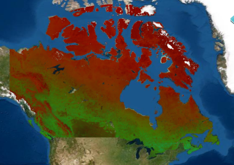
Dynamic Habitat Index (2000-2006)
Simple
- Date ( RI_367 )
- 2008
- Date ( RI_366 )
- 2008
(250) 363-6004
https://cfs.nrcan.gc.ca/employes/vue/mwulder
- Hours of service
- email only please
- Status
- completed; complété RI_593
- Maintenance and update frequency
- asNeeded; auBesoin RI_540
- Government of Canada Core Subject Thesaurus Thésaurus des sujets de base du gouvernement du Canada ( RI_528 )
-
- Forests
- Use limitation
- Open Government Licence - Canada (http://open.canada.ca/en/open-government-licence-canada)
- Access constraints
- otherRestrictions; autresRestrictions RI_609
- Use constraints
- intellectualPropertyRights; droitsPropriétéIntellectuelle RI_607
- Other constraints
- Dynamic Habitat Index. (2000-2005) Satellite derived estimates of photosynthetically active radiation can be obtained from satellites such as MODIS. Knowledge of the land cover allows for calculation the fraction of incoming solar radiation that is absorbed by vegetation. This fraction of photosynthetically active radiation (fPAR) absorbed by vegetation describes rate at which carbon dioxide and energy from sunlight are assimilated into carbohydrates during photosynthesis of plant tissues. The summation of carbon assimilated by the vegetation canopy over time yields the landscape's gross primary productivity. Daily MODIS imagery is the basis for periodic composites and monthly data products. Over the 6 year period from 2000-2005, we calculate the annual average cumulative total of 72 monthly fPAR measurements, to describe the integrated annual vegetative production of the landscape, the integrated average annual minimum monthly fPAR measurement, which describes the annual minimum green cover of the observed landscape, and the integrated average of the annual covariance of fPAR, which describes the seasonality of the observed landscape. We also share the combination of the annual integrated values for visualization and analysis as the Dynamic Habitat Index (with additional information in Coops et al. 2008). When using this data, please cite as: Coops, N.C., Wulder, M.A., Duro, D.C., Han, T. and Berry, S., 2008. The development of a Canadian dynamic habitat index using multi-temporal satellite estimates of canopy light absorbance. Ecological Indicators, 8(5), pp.754-766. ( Coops et al. 2008).after August 31 may not always be mapped to the correct year; however a national independent accuracy assessment indicated that 97.7% of changes were labelled to within ± 1 year (Hermosilla et al. 2016; http://www.tandfonline.com/doi/full/10.1080/17538947.2016.118767 )
- Spatial representation type
- grid; grille RI_636
- Metadata language
- eng
- Topic category
-
- Geoscientific information
- Begin date
- 2000
- End date
- 2006
))
- Reference system identifier
- http://www.epsg-registry.org / EPSG:3978 / 1.0
- Distribution format
-
-
GeoTIF
(
1.0
)
-
GeoTIF
(
1.0
)
(250) 363-6004
https://ca.nfis.org/index_eng.html
- Hours of service
- email only please
- OnLine resource
-
A nationwide annual characterization of 25 years of forest disturbance and recovery for Canada using Landsat time series
(
HTTP
)
Supporting Document;HTML;eng
- OnLine resource
-
CA_DHI_mean_2000_2005
(
OGC:WMS
)
Web Service;WMS;fra
- OnLine resource
-
CA_DHI_mean_2000_2005
(
OGC:WMS
)
Web Service;WMS;eng
- OnLine resource
-
Dynamic Habitat Index 2000-2006
(
HTTPS
)
Dataset;ZIP;eng
- OnLine resource
-
The development of a Canadian dynamic habitat index using multi-temporal satellite estimates of canopy light absorbance
(
HTTPS
)
Supporting Document;PDF;eng
- File identifier
- 7d4df1c9-02f4-4ab2-ac1a-fd4b67f785f2 XML
- Metadata language
- eng; CAN
- Character set
- utf8; utf8 RI_458
- Hierarchy level
- dataset; jeuDonnées RI_622
- Date stamp
- 2026-02-17T16:25:20
- Metadata standard name
- North American Profile of ISO 19115:2003 - Geographic information - Metadata
- Metadata standard version
- CAN/CGSB-171.100-2009
(250) 363-6004
https://cfs.nrcan.gc.ca/employes/vue/mwulder
- Hours of service
- email only please
Overviews


Spatial extent
Provided by
