 Arctic SDI catalogue
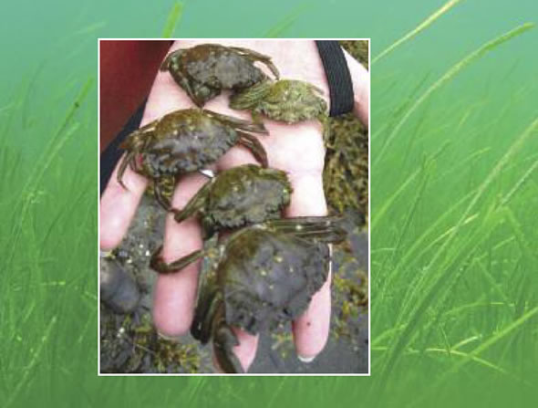
DFO Gulf Region European Green Crab Monitoring Dataset
PURPOSE:
Provide presence/absence and abundance data for the non-indigenous and invasive European green crab (EGC) in selected southern Gulf of St. Lawrence (sGSL) estuaries along the Northumberland Strait coast of New-Brunswick and eastern Prince-Edward-Island.
DESCRIPTION:
Temporal monitoring during ice-free seasons of European green crab abundance is completed in response to previous regional population declines in the Maritime provinces.
Note that where presence is not indicated on the map does not mean absence - this survey is limited to a few sites.
Traps that did not fish correctly were not included in the dataset. Examples of defective traps include: an open trap, an open bait container, a trap filled with algae and falling into the open position, a trap that has not been fished for over 48 hours, an overturned trap, or a trap that has been significantly moved or otherwise tampered with.
Population estimates are not derived from this data.
PARAMETERS COLLECTED:
1) EGC count, size measurement, sex, and catch weight
2) Counts of bycatch species. Categories reported in this dataset are finfish (cunner, striped bass, mummichog, winter flounder, smooth flounder, sculpin, tomcod, American eel, banded killifish, flounder, unknown bony fish), Atlantic rock crab, American lobster, and other (lion's mane jellyfish, moon jellyfish, other crabs, moon snail). Other smaller species were often in the trap but were not included as bycatch in this dataset as they can easily escape the mesh size and would not consistently be trapped.
3) Environmental data: water depth at trap setting, sediment type, vegetation types noted, salinity, water temperature, dissolved oxygen (not included), specific conductance (not included), conductivity (not included), weather, cloud cover (not included), tide state and direction (upon fishing).
NOTES ON QUALITY CONTROL:
Data entry of morphological parameters randomly verified for accuracy.
Weights are not reported for PEI sites due to inconsistencies with types of weighing scales and measurement protocols.
PHYSICAL SAMPLE DETAILS:
Whole European green crab specimens
SAMPLING METHODS:
Baited trapping with Fukui traps. Bait was in a bait can or bag. Types of bait included herring (predominant type used), as well as other species when herring were not available (gaspereau, canned fish [tuna, kippers, snack sardines], mackerel, tilapia, and perch).
USE LIMITATION:
To ensure scientific integrity and appropriate use of the data, we would encourage you to contact the data custodian.
Simple
- Date ( RI_366 )
- 2023-05-16
- Date ( RI_367 )
- 2026-05-01
- Purpose
- Provide presence/absence and abundance data for the non-indigenous and invasive European green crab (EGC) in selected southern Gulf of St. Lawrence (sGSL) estuaries along the Northumberland Strait coast of New-Brunswick and eastern Prince-Edward-Island.
- Status
- onGoing; enContinue RI_596
- Maintenance and update frequency
- asNeeded; auBesoin RI_540
- uncontrolled vocabulary; user-specified vocabulaire libre; spécifié par l'utilisateur ( RI_528 )
-
- Fukui Trap
- NASA/Global Change Master Directory (GCMD) Science Keywords Version 6.0.0.0.0 NASA/Global Change Master Directory (GCMD) Science Keywords Version 6.0.0.0.0 ( RI_528 )
-
- Invasive Species
- Marine Environment Monitoring
- TRAPS
- Integrated Taxonomic Information System (ITIS) Système d'information taxonomique intégré (SITI) ( RI_528 )
-
- Carcinus maenas
- Government of Canada Core Subject Thesaurus Thésaurus des sujets de base du gouvernement du Canada ( RI_528 )
-
- Invasive species
- DFO Areas Zones du MPO ( RI_525 )
-
- Gulf of St. Lawrence
- Use limitation
- Open Government Licence - Canada (http://open.canada.ca/en/open-government-licence-canada)
- Access constraints
- license; licence RI_606
- Use constraints
- license; licence RI_606
- Use limitation
- To ensure scientific integrity and appropriate use of the data, we would encourage you to contact the data custodian.
- Use limitation
- none
- Classification
- unclassified; nonClassifié RI_484
- Spatial representation type
- textTable; texteTable RI_637
- Metadata language
- eng; CAN
- Character set
- utf8; utf8 RI_458
- Topic category
-
- Biota
- Oceans
- Begin date
- 2023-05-16
- End date
- 2024-10-30
- Description
- Five estuaries (Bouctouche, Cocagne, and Shediac (NB) as well as Georgetown and St. Mary's Bay (PEI)) and opportunistic monitoring at Bathurst (NB), Caraquet (NB), Coastal near Belledune/Pointe Verte (NB), Heron Island (NB), Miscou Harbour (NB), Shippigan (NB), Tabusintac (NB), and Tracadie (NB)
))
- Reference system identifier
- http://www.epsg-registry.org / EPSG:4326
- Distribution format
-
-
CSV
(
n/a
)
-
ESRI REST
(
n/a
)
-
CSV
(
n/a
)
- OnLine resource
-
European Green Crab Monitoring Data
(
HTTPS
)
Dataset;CSV;eng,fra
- OnLine resource
-
Data dictionary
(
HTTPS
)
Supporting Document;CSV;eng,fra
- OnLine resource
-
European Green Crab (EGC) 2023-2024
(
ESRI REST: Map Service
)
Web Service;ESRI REST;eng
- OnLine resource
-
European Green Crab (EGC) 2023-2024
(
ESRI REST: Map Service
)
Web Service;ESRI REST;fra
- File identifier
- 7dac1fec-93fc-11ea-a132-f48c505b2a29 XML
- Metadata language
- eng; CAN
- Character set
- utf8; utf8 RI_458
- Hierarchy level
- dataset; jeuDonnées RI_622
- Date stamp
- 2026-05-12T19:30:03.312293Z
- Metadata standard name
- North American Profile of ISO 19115:2003 - Geographic information - Metadata
- Metadata standard version
- CAN/CGSB-171.100-2009
Overviews
Spatial extent
Provided by
